Sorry if already posted:
http://9to5mac.com/2012/07/26/googl...c+-+Apple+Intelligence)&utm_content=Google+UK
http://9to5mac.com/2012/07/26/googl...c+-+Apple+Intelligence)&utm_content=Google+UK


Actually its out now, downloading on my iPhone 4S!
----------
Quick first impressions, a bit slower than Apple's and not sure the 3D cities look quite as realistic. Too early to really tell though.
----------
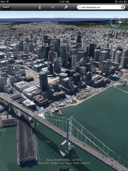
Here we go, direct comparison:
Apple Maps:
Image
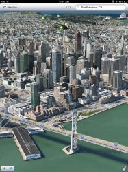
Google Earth:
Image
Looks a LOT better on Apple Maps Id say.


am i the only one who cant get the 3d to work? i have it checked off in the options
i have a 4s
Sorry if already posted:
http://9to5mac.com/2012/07/26/googl...c+-+Apple+Intelligence)&utm_content=Google+UK

Apple has more detail...
But in the 1st 2 pictures Google's colors are much better than Apples.
May I ask, what's the point of 3D maps? Isn't it just a gimmick? There's no use for it, or am I missing something?
Apple has more detail...
But in the 1st 2 pictures Google's colors are much better than Apples.
May I ask, what's the point of 3D maps? Isn't it just a gimmick? There's no use for it, or am I missing something?
Are you serious? In the first 2 pictures the Google Earth one looks like a cartoon. Not to mention the poor texture detail on nearly everything compared to the Apple Maps version.
As for the point, it gives you an incredibly detailed photo realistic 3D view of a city. If you think that is pointless then that must mean that detailed satellite imagery is pointless as well
Yeah just to look at a city in 3D isn't gimmicky?? Come on
And no I don't think detailed satellite imagery is pointless. It's two different things.
At least detailed satellite imagery is useful for maps/directions/navigation.
Not trying to bash 3D maps, it just doesn't seem like its something that is needed when they're trying to compile their own maps at the same time. If they had maps all done then sure, no problem

Maybe now the google maps fanboys will shut it..... Eh probably not.