Become a MacRumors Supporter for $50/year with no ads, ability to filter front page stories, and private forums.

MacRumors

macrumors bot
Original poster
Apr 12, 2001
63,441
30,638


Several months ago, we noted that major GPS company Garmin was considering developing iOS applications after abandoning its partnership with ASUS to produce Garmin-branded phones, and it now appears that Garmin has followed through on those plans.


104917-garmin_streetpilot.jpg


Garmin today announced a number of new standalone GPS products and iOS and Android applications, with the most prominent of those applications being Garmin StreetPilot [App Store, $39.99] for the iPhone.
The StreetPilot App includes many of the same high-end features available on Garmin's standalone automotive GPS devices like free traffic alerts that enable drivers to steer clear of traffic accidents, road closures and construction; lane assist with junction view that directs drivers to the preferred lane and displays realistic images of upcoming complex junctions; and speed limit indicators that display speed limits for most major roads.
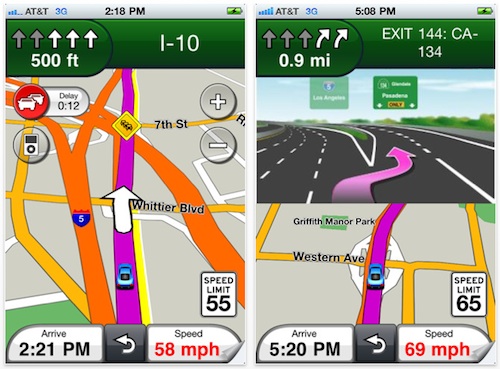
Garmin StreetPilot also supports multitasking under iOS 4 and integrates with users' music libraries and address books.

Unlike some of the other mainstream GPS applications for the iPhone, Garmin StreetPilot downloads map content as needed, as opposed to storing the entire map database within the application. While the decision allows Garmin to offer smaller downloads that require less on-device storage and quicker download and syncing times, as well as automatic access to the latest map updates, the trade-off is that users must be in areas with data service coverage in order for the application to function properly.

Article Link: 'Garmin StreetPilot' Debuts in App Store
 

pugnut

macrumors 6502a
Jul 1, 2007
809
0
Really

Whoever advised them to not put the maps onboard and download as needed, needs to be fired- poor decision.
 
Last edited:

OneMike

macrumors 603
Oct 19, 2005
5,814
1,795
bad decision. apps like motion gps I'd pay $0.99 for and use the maps over the air.

If I'm going to pay $40 for a gps app it'd be cause I relied on it. Wouldn't chance having service.
 

TheRealTVGuy

macrumors 6502a
Jul 21, 2010
704
1,156
Orlando, FL
I thought there were some free map/gps/turn-by-turn direction apps out there (ala Google Maps). Is this not the case? Can anyone tell me why you would want to purchase one of the Garmin/Tom-Tom apps?
 

Small White Car

macrumors G4
Aug 29, 2006
10,966
1,463
Washington DC
Whoever advised them to now put the maps onboard and download as needed, needs to be fired- poor decision.
bad decision. apps like motion gps I'd pay $0.99 for and use the maps over the air.

If I'm going to pay $40 for a gps app it'd be cause I relied on it. Wouldn't chance having service.


I've been using the iPhone's Google maps in that way for almost 3 years and I have not once had that be an issue.

I dunno, I guess something bad could happen, but it sure doesn't seem likely to me at this point. And even if it does happen to me soon I'm prepard for "once every 3 years" as a failure rate.

Agreed. Downloading anything on Edge is awful, but downloading mission critical graphical maps and directions when you get lost? Just dumb.

Ok, but when a road changes and you don't have the newest map then what are you doing? Manually downloading is what.

I'd rather it be an automatic process.

Both methods have drawbacks: "Not always available" vs. "Not always current."
Given that I've never had a problem with availability, I'm actually interested in an app that promises to stay current without my having to download maps manually ahead of time.
 

ihav0frnds

macrumors 6502
Jun 6, 2010
304
6
I've been using the iPhone's Google maps in that way for almost 3 years and I have not once had that be an issue.

I dunno, I guess something bad could happen, but it sure doesn't seem likely to me at this point. And even if it does happen to me soon I'm prepard for "once every 3 years" as a failure rate.

2d vs 3d...pretty different data consumption
 

alangrehan

macrumors regular
Jan 15, 2008
172
12
I used to have a Garmin Nuvi but I won't be going anywhere near this!

I'd say your 500MB data allowance on O2 would be churned up in no time.

What's the problem with downloading the maps? TomTom takes up about 2-3GB on my 32GB iPhone... big deal!
 

Small White Car

macrumors G4
Aug 29, 2006
10,966
1,463
Washington DC
2d vs 3d...pretty different data consumption

The 3D is generated on the phone. The map data itself really shouldn't be any different at all. Right?

I'd say your 500MB data allowance on O2 would be churned up in no time.

This should be exactly the same as using the Apple maps app in terms of bandwidth. Are people really killing their data plans using Google maps?
 

guzhogi

macrumors 68040
Aug 31, 2003
3,733
1,824
Wherever my feet take me…
IBoth methods have drawbacks: "Not always available" vs. "Not always current."
Given that I've never had a problem with availability, I'm actually interested in an app that promises to stay current without my having to download maps manually ahead of time.

I wonder why the 2 plans have to be mutually exclusive. Why not download the whole database when you get it, for when you might not get coverage. And then automatically update when you do have coverage. When going somewhere, give priority updating to the current route and then download everything else. Maybe allow current route to be updated with EDGE/3G while whole database updates require Wi-Fi. Just my 2¢
 

Tilpots

macrumors 601
Apr 19, 2006
4,195
71
Carolina Beach, NC
Ok, but when a road changes and you don't have the newest map then what are you doing? Manually downloading is what.

I'd rather it be an automatic process.

Both methods have drawbacks: "Not always available" vs. "Not always current."
Given that I've never had a problem with availability, I'm actually interested in an app that promises to stay current without my having to download maps manually ahead of time.

Every situation is different, granted, but a re-route due to road change is so much less likely to occur than a traffic congestion re-route or other spur of the moment situation. If you're not in a 3G area, forget it. I'll take my chances with an "outdated" map than I will with not being able to quickly access any map at all every time.
 

wacky4alanis

macrumors 6502a
Mar 18, 2009
555
79
Not interested - the Tom Tom app is great, and I don't have to worry about data coverage. When you drive around in rural areas, it can definitely be a big issue. There are plenty of much cheaper apps that download maps on the fly. Free traffic is a plus though - that may be the one selling point. I have to pay a yearly fee with Tom Tom.
 

malnar

macrumors 6502a
Aug 20, 2008
634
60
Damn. The map-download thing is the one thing keeping me from buying this immediately. I have both TomTom and Navigon's apps and switch between the two from time to time because neither does what I want - basically, I've wanted the Garmin experience on the Iphone but the freedom of the Iphone (and updates, etc. the apps have allowed.)

My guess is that the maps download to your phone and are not constantly being pulled in, so a mapped-out drive from one city to another that passes through a dead zone isn't going to result in an area with no maps. But that one small issue of getting stuck in a no-coverage area and desperately needing it is worrisome.

That said, Garmin has everything else covered here -traffic, map updates, etc. The download issue really should be a minimal problem for most people who aren't traveling in iffy areas. I *really* want to get back to using a Garmin product without buying a standalone unit.
 

Small White Car

macrumors G4
Aug 29, 2006
10,966
1,463
Washington DC
I wonder why the 2 plans have to be mutually exclusive. Why not download the whole database when you get it, for when you might not get coverage. And then automatically update when you do have coverage. When going somewhere, give priority updating to the current route and then download everything else. Maybe allow current route to be updated with EDGE/3G while whole database updates require Wi-Fi. Just my 2¢

The problem with this plan is that they're specifically bragging about stuff like construction updates, points of intrest, and traffic alerts.

In other words, you'll have a system that's constantly downloading stuff AND taking up 3 GB on your phone. I'd be happier to pick one or the other and not have to have the worst of both plans.

Your idea could work for another GPS app that's not built to highlight those kind of things, but that doesn't seem to be the app that Garmin wanted to make.

My guess is that the maps download to your phone and are not constantly being pulled in, so a mapped-out drive from one city to another that passes through a dead zone isn't going to result in an area with no maps. But that one small issue of getting stuck in a no-coverage area and desperately needing it is worrisome.

That's something I'd like them to clarify, actually.

Is it like Google maps and just downlaods "where you are" or is it downloding your whole state and the surrounding states? Or, like "North-East" or something like that?

The difference between those 2 systems could actually mean a lot for some of you folks, it seems.
 

mad-dog-one

macrumors 6502
Aug 14, 2009
345
0
Whoever advised them to now put the maps onboard and download as needed, needs to be fired- poor decision.

I agree. I need my GPS to have maps where I am, particularly when I'm in remote areas out of wifi and cell phone range.
 

wacky4alanis

macrumors 6502a
Mar 18, 2009
555
79
I wonder why the 2 plans have to be mutually exclusive. Why not download the whole database when you get it, for when you might not get coverage. And then automatically update when you do have coverage. When going somewhere, give priority updating to the current route and then download everything else. Maybe allow current route to be updated with EDGE/3G while whole database updates require Wi-Fi. Just my 2¢

Tom Tom is moving towards this... the latest version allows users to submit map update info, and then allows other users to download that info. I'm not sure what it includes because I haven't played with it, but I have noticed it downloading the updates for me every couple of weeks (over 3G, not wifi). It asks when you start up if you want to download the updates.
 

kas23

macrumors 603
Oct 28, 2007
5,629
288
Garmin, a little late to the game aren't we?

As for downloading maps on-the-fly, bad decision. True, I went many years using Google Maps for directions without major problems, but there definitely were some major headaches along the way. I can remember critical times when the I would be staring at a blue dot amongst a sea of gray. I mean, I still alive, so it couldn't have caused much trouble, right?
 

OneMike

macrumors 603
Oct 19, 2005
5,814
1,795
Garmin, a little late to the game aren't we?

Late yes, but I think it's not about who gets in first but who does it best. That said. I don't see how over the airs maps can be considered best.
 

Gemütlichkeit

macrumors 65816
Nov 17, 2010
1,276
0
I can't trust the cellphone networks to stream the data to me. Much rather have the maps on the phone.
 

wwchris

macrumors regular
Nov 13, 2009
154
164
Atlanta, GA
Yeah, Tom Tom is finally getting this right after all kinds of problems. Once a week (if you choose) you get prompted to download a 1 meg'ish patch. You can do it anywhere and it patches the existing stored maps, no live feed necessary. Takes about 5 seconds.

You do need live feed for traffic, but of course, that is the whole point of that.

BTW, their traffic is awesome now and the routing bugs are finally fixed. Also, their crowd sourced arrival times are the most accurate on any of the platforms and it consistently chooses the shortest route.

I was a Garmin lover and wanted it to desperately come to the iphone, but not with maps like this. Now that Tom Tom is finally getting it right, I won't be getting this.
 

BC2009

macrumors 68020
Jul 1, 2009
2,237
1,393
I thought there were some free map/gps/turn-by-turn direction apps out there (ala Google Maps). Is this not the case? Can anyone tell me why you would want to purchase one of the Garmin/Tom-Tom apps?

Google Maps will give you directions, but will not give you a turn-by-turn 3D view that tracks your position and shows you which lanes to get in, etc.... Google has a turn-by-turn nav app for Android though.

Also, Navigon and Tom-Tom will download all the maps you purchased with the app, so you have access to maps even when hiking or driving on a remote trail where there is no service available. Both Navigon and Tom-Tom are moving toward a model where if the map is wrong you can report that it is incorrect and they can fix it faster and provide updates.

Real-time maps means they are up-to-date, when you have network (similar to Google Maps).

I think Garmin failed on this one -- additionally the interface looks a bit cartoony.
 

coolbreeze

macrumors 68000
Jan 20, 2003
1,808
1,552
UT
Is the animation smooth or jerky like all Garmins (unlike TomTom's smooth animation).
 

macnews

macrumors 6502a
May 12, 2003
602
5
Idaho
I've been using the iPhone's Google maps in that way for almost 3 years and I have not once had that be an issue.

I dunno, I guess something bad could happen, but it sure doesn't seem likely to me at this point. And even if it does happen to me soon I'm prepard for "once every 3 years" as a failure rate.


Ok, but when a road changes and you don't have the newest map then what are you doing? Manually downloading is what.

I'd rather it be an automatic process.

Both methods have drawbacks: "Not always available" vs. "Not always current."
Given that I've never had a problem with availability, I'm actually interested in an app that promises to stay current without my having to download maps manually ahead of time.

Since you are already using Google maps this way, then why pay $40 for a service? Traffic updates? Road directions? Talking to you? All fine things but I have also been using Google maps this way and have had refresh problems in areas of otherwise good coverage. I would pay for a map service which had a small local map (say one in a 200 mile radius of your main zip code) that I could have on board. Using over the air, I'll just stick with free google maps.
 
Register on MacRumors! This sidebar will go away, and you'll see fewer ads.