Become a MacRumors Supporter for $50/year with no ads, ability to filter front page stories, and private forums.
6.0.1 has improved maps!
- Thread starter dj95
- Start date
- Sort by reaction score
You are using an out of date browser. It may not display this or other websites correctly.
You should upgrade or use an alternative browser.
You should upgrade or use an alternative browser.
Just looked around at a few places in the UK and the maps have definitely improved. Before the update I couldn't zoom in on many areas when in satellite mode around where I live as all it would show was a no image icon. At last")
The Maps app takes it data from a central server, where changes can be made at will by Apple. An update to iOS does not bring actual changes to the Maps data, as this can be done at any time on the server itself.
The new data, if any, seems to have coincided with iOS 6.0.1's release rather than have been caused by it.
I can see my house again via the satellite view, pity the POIs i've reported as wrong haven't been corrected. One thing at a time i guess.
I wish the search would work better though. I put sainsburys, northampton and it can't find it (listed as J Sainsbury). I put just northampton and it sends me off across to the states. US-centric searches like this irritate me!
Bridge Renders
I noticed last week that they had improved a number of the bridge renders in NYC that originally appeared 'flattened' so I think that improving the maps overall is an ongoing and incremental process for them.
Hopefully they revise the algorithm for the turn-by-turn directions, also. In my tests the routes Mapple chooses are far inferior to what the Tomtom app for iOS chooses.
I can also confirm that the map data for my area has improved greatly. There is a small forest area behind my home which previously was parted in two, over two tiles, one side reasonably high resolution and the other pixelated.
The full surrounding area is now complete and higher resolution.
The full surrounding area is now complete and higher resolution.

Still pathetic where I live. Satellite view is blurry and in black and white. I'm in North America.
Pathetic. Apple has the largest war chest of any tech company in the world but can't be bothered to purchase colour satellite images for a relatively populous area?
Pathetic. Apple has the largest war chest of any tech company in the world but can't be bothered to purchase colour satellite images for a relatively populous area?
Nothing here... it's still placing my (and most of my community) in the middle of the vacant woods.
It's now using google maps for my area!
It's also improved here too.
I thought it hadn't at first but once I had zoomed out and in again, the new data loaded so its not just a blur .
It's now using google maps data ! I confirmed by loading google maps and the shadows in the satellite images are exact, as is the image itself
It's also improved here too.
I thought it hadn't at first but once I had zoomed out and in again, the new data loaded so its not just a blur .
It's now using google maps data ! I confirmed by loading google maps and the shadows in the satellite images are exact, as is the image itself
Last edited:
It's also improved here too.
I thought it hadn't at first but once I had zoomed out and in again, the new data loaded so its not just a blur .
It's now using google maps data ! I confirmed by loading google maps and the shadows in the satellite images are exact, as is the image itself
While Glasgow is improved in places, nowhere is yet using images anywhere near the quality of Google's map imagery.
York's satellite imagery is greatly improved. It's now in colour. View attachment 374248
Just noticed this too. Now full colour when I zoom fully into my house, but still black and white when zoomed out a little bit
I don't think the map updates have anything to do with 6.0.1
I'm still on 6.0.0 but can see improvements to the mapping data. A few of the larger local towns are now labeled and I can see a village has been moved to it's correct place and the satellite images are much improved.
Dudley is still 7 miles out of place though and I haven't noticed any improvements to the POIs. At least they've made a start.
Most of my town is now in colour! I say "most", because the northeast is still greyscale
Edit: But Google's not perfect either!
Edit: But Google's not perfect either!
Last edited:
Great for you guys then. As far as I'm concerned, my area Singapore still looks like some iCloud city, Apple hasn't made any changes since I reported it like 1 month ago. Why do I get the feeling that they're more inclined to fix the Western and European states than Asian ones?
Also, if you're currently in the middle of driving to a destination, Maps will give you an eta now, I didn't notice it before in ios6
My street is still spelled wrong.
Are you serious?!?! Thank god. I was annoyed losing that when I ditched my GPS for my iPhone.
Also, if you're currently in the middle of driving to a destination, Maps will give you an eta now, I didn't notice it before in ios6
Are you serious?!?! Thank god. I was annoyed losing that when I ditched my GPS for my iPhone.
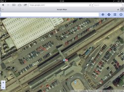
Here is confirmation that the google maps data is the same as apple maps in 6.01 for me
You posted the same picture three times. A screen shot of Safari on your iPad running Google Maps.
You should compare it to the actual Maps application...
Are you serious?!?! Thank god. I was annoyed losing that when I ditched my GPS for my iPhone.
I know! I was pleasantly surprised earlier today.
Also, if you're currently in the middle of driving to a destination, Maps will give you an eta now, I didn't notice it before in ios6
I'm sure that was there before, they've just made the font bigger I think.
----------
It no longer thinks my house is the entire Yorkshire Dales National Park when planning a route home.
I'm sure that was there before, they've just made the font bigger I think.
ETA has always been there. While in navigation mode: Press the screen to get ETA and other information about your route. Press the screen again to hide this information.
Register on MacRumors! This sidebar will go away, and you'll see fewer ads.