Become a MacRumors Supporter for $50/year with no ads, ability to filter front page stories, and private forums.

MacRumors

macrumors bot
Original poster
Apr 12, 2001
68,179
38,960


Apple today made several updates to its Maps app around the world, adding new Flyover locations, expanding Maps Traffic info, and bringing the Nearby feature in Maps to additional countries.

New Flyover locations available today include Aomori, Japan; Bruges, Belgium; Lake Powell, Utah; and Limoges, France. Some of the locations listed may have previously been available as Flyover destinations, but were just added to Apple's list of Flyover locations.

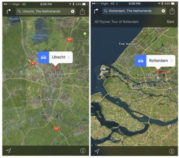
For those unfamiliar with the Flyover feature in Apple Maps, it lets users see photo-realistic 3D videos of select locations, with tools for zooming, panning, and rotating to get a closer look at notable landmarks and points of interest.

mapsbruges-800x450.jpg

Along with new Flyover locations, Apple's website has been updated to note that traffic information is now available in the Maps app in Hong Kong and Mexico, bringing the total number of countries with traffic data available to 29.

Nearby, a feature introduced with iOS 9, has also been expanded to the Netherlands and the United Kingdom. Nearby brings up local points of interest in the Maps app, allowing users to quickly locate restaurants, gas stations, coffee shops, and more.

Finally, Los Angeles is now listed as an official location with transit directions available, joining Baltimore, Maryland; Berlin, Germany; Boston, Massachusetts; Chicago, Illinois; London, England; Mexico City, Mexico; New York City, New York; Philadelphia, Pennsylvania; San Francisco, California; Sydney, Australia; Toronto, Canada; Washington, DC; and China.

Transit information first became available in Los Angeles in December of 2015.

Article Link: Apple Maps Gains New Flyover Locations, Traffic Info Now Available in Hong Kong and Mexico
 
Yay more flyovers, now if only Maps actually allowed you to actually find what you were searching for I'd try it out again. Stop making it pretty and fix the overall tech please.
 
No matter how much I want to like Apple Maps, this is an area where Google is much much better.

Flyover is completely useless against Street View, the later is so convenient when trying to know exactly where the place you are going is, and how it looks from the outside.
 
There was actually traffic information in St. Thomas, U.S. Virgin Islands. Thought that was pretty cool.
 
No matter how much I want to like Apple Maps, this is an area where Google is much much better.

Flyover is completely useless against Street View, the later is so convenient when trying to know exactly where the place you are going is, and how it looks from the outside.

I think street view well be a main feature of iOS 10 later this year.
 
We've had driving directions since 20 years ago. Flyover is more useful for birds and drones and iPhone users.

Meanwhile, Google Maps has given us bike routes, public transport and street view.
 
  • Like
Reactions: RoelJuun
Apple maps adds a large blue circle in semi transparency over my location, therefore the whole program is practically unusable. I am just amazed at the fact that nobody working o the maps application noticed the problem.
 
Yay more flyovers, now if only Maps actually allowed you to actually find what you were searching for I'd try it out again. Stop making it pretty and fix the overall tech please.

One doesn't rely on the other. They have been improving other aspects too.

Flyover is completely useless against Street View, the later is so convenient when trying to know exactly where the place you are going is, and how it looks from the outside.

We've had driving directions since 20 years ago. Flyover is more useful for birds and drones and iPhone users.

I disagree. I like and use both Street View and Flyover. But use them for different things.

When I'm in a new City, Flyover is great for getting a quick and dirty look around - more detailed than a flat map but way faster to navigate than Street View. It was great when I visited Rome 2 years ago - lots of winding alleys that look similar, Flyover helped a lot. Street View in this situation would be slow and annoying.

Street View is great when I have more time and want more detail. Pretty rare that I actually need it day to day but when I do it's really useful. When I bought my house I used it to check the surrounding streets.

I'm glad on iOS I have both.
 
Street View will come to Apple Maps, obviously. Apple has the money and the will to deploy a larger scale effort than Google's.

When available, Flyover is like magic. I spend hours on it with my daughter.

Integrate the two technoligies and you'll get the next gen maps.
 
Just wait until Apple's version of street view hits on iOS 10.

Seamless integration with Flyover, and three-dimensional free movement throughout a city, at street level and above, not restricted to teleporting between bubbles as per Google's Streetview.

There is a reason these cars have been spotted everywhere over the last year or so.

apple_maps_car_634x306x24_expand_h345b2ce5.jpg


Finally, Los Angeles is now listed as an official location with transit directions available, joining Baltimore, Maryland; Berlin, Germany; Boston, Massachusetts; Chicago, Illinois; London, England; Mexico City, Mexico; New York City, New York; Philadelphia, Pennsylvania; San Francisco, California; Sydney, Australia; Toronto, Canada; Washington, DC; and China.

Transit information first became available in Los Angeles in December of 2015.

Article Link: Apple Maps Gains New Flyover Locations, Traffic Info Now Available in Hong Kong and Mexico

China doesn't have just one city named China.
 
  • Like
Reactions: Mactendo
Just wait until Apple's version of street view hits on iOS 10.

Seamless integration with Flyover, and three-dimensional free movement throughout a city, at street level and above, not restricted to teleporting between bubbles as per Google's Streetview.

There is a reason these cars have been spotted everywhere over the last year or so.

apple_maps_car_634x306x24_expand_h345b2ce5.jpg

I'm also hoping that this means Apple will be replacing most of the third party data with their own.
 
Bruges is not working. A while ago, Utrecht was added to the same list. Does anybody know why it's still not working. Can't get Antwerp either. Nor Munster.
All these cities are listed.
 
Bruges is not working. A while ago, Utrecht was added to the same list. Does anybody know why it's still not working. Can't get Antwerp either. Nor Munster.
All these cities are listed.

All of them work fine for me. Were you in low power mode?
 
All of them work fine for me. Were you in low power mode?
Ok good to know. I have tried a couple of times over the last weeks, both on iOS and OS X latest versions. It's always the same (listed) cities that don't work and others that do. I don't know of any other way to invoke the flyover than to just type the city in the search box and it pops up at the bottom (or not in this case).
I tried 4 iPads, 2 iPhones an iMac and an MBP. See screenshots
 

Attachments

  • Untitled.jpg
    Untitled.jpg
    204.9 KB · Views: 138
Last edited:
Yay more flyovers, now if only Maps actually allowed you to actually find what you were searching for I'd try it out again. Stop making it pretty and fix the overall tech please.
exactly, I tried out waze the other day an it was miles ahead, but neither were as good as a dedicated standalone sat nav.
 
Apple has flyovers for many cities in the US and around the world. However the capital of the US and one of the more important cities remains off the list. What could this mean?
 
Ok good to know. I have tried a couple of times over the last weeks, both on iOS and OS X latest versions. It's always the same (listed) cities that don't work and others that do. I don't know of any other way to invoke the flyover than to just type the city in the search box and it pops up at the bottom (or not in this case).
I tried 4 iPads, 2 iPhones an iMac and an MBP. See screenshots
What you show on a screenshot is a Flyover tour, it's an addition to Flyover in some cities. To Flyover over any city with or without tour you just zoom in very close and map turns into 3D.
[doublepost=1453651948][/doublepost]
You gotta check out the new flyover cities. Bakersfield, CA is by far the best flyover I have seen!!!
OMG, I just checked Bakersfield, the place is amazing! Looks like Area 51 unfolded, so eerie.
 
  • Like
Reactions: Knar
Just wait until Apple's version of street view hits on iOS 10.

Seamless integration with Flyover, and three-dimensional free movement throughout a city, at street level and above, not restricted to teleporting between bubbles as per Google's Streetview.

There is a reason these cars have been spotted everywhere over the last year or so.

apple_maps_car_634x306x24_expand_h345b2ce5.jpg
Okay, this is news to me; who knew apple were doing their own street-view! Cool:cool: and by the look of the picture it looks like UK reg plates.
 
Register on MacRumors! This sidebar will go away, and you'll see fewer ads.