Become a MacRumors Supporter for $50/year with no ads, ability to filter front page stories, and private forums.

razorianfly

macrumors 65816
Original poster
Oct 16, 2007
1,357
0
Cheshire, United Kingdom
Has anyone seen/bought this yet?

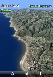
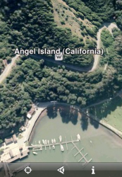
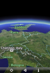
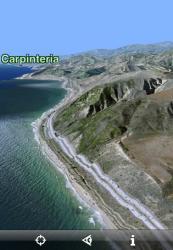
It looks awesome. This is Google Maps. This is full 3D, tilt-orientated scaping of the globe!

All I can say is, if this is the 'basic' version of the application, I can't wait to see what the advanced version is capable of ... :cool:

App Store: EarthScape

R-Fly
 

Attachments

  • Picture 10.png
    Picture 10.png
    259.9 KB · Views: 163
  • Picture 11.png
    Picture 11.png
    239.5 KB · Views: 109
  • Picture 12.png
    Picture 12.png
    293 KB · Views: 123
  • Picture 13.png
    Picture 13.png
    188.4 KB · Views: 111
It does look pretty cool but who is going to pay £5.99 when GoogleMaps comes as part of the iPhone? I wouldn't pay £5.99 just for 3D loveliness!

Am I missing something?
 
Looks pretty nice with the touch controls:

http://www.youtube.com/watch?v=Jw4Lfhu0ADw


Wish it had a flying mode with tilt controls since it looks so nice that it could be peaceful and kind of amazing.

Though, $10 is a lot. Sure, it's cool, but is it usefull. I mean, besides links to Wiki on landmarks, does it do anything else? Besides locate you, can you search like google? Can you drop pins? Set routes, and fly that route. Bookmark locations? E-mail a location?

So for $10, I expect something useful, so I'm hesitating to drop the cash on it.

The current video linked to has only 3 icons, but this video from a month ago has more. Are those there in the full app? They hardly say anything of features.
http://www.youtube.com/watch?v=yRVSW3vlaQ4&feature=related
 
A couple things to note after purchasing this app:

1. Very easy to navigate. Zoom in by tapping twice on the screen and it zooms in pretty quickly. Don't attempt to zoom on edge, it will take some time to load a map.

2. Maps are at least two years old if not older. I used the locate me feature in the app and it quickly found my house. How do I know the map is at least two years old? My yard was landscaped two summers ago and the map still shows the old yard and an old car in the driveway I no longer own. This won't be a problem for sometimes but in newly developed areas, this will be a problem.

3. Impressed with the maps and the angle views. Well worth $10.
 
Support for Flickr photos - through Geotagging?

Seems like it.

http://uk.youtube.com/watch?v=yRVSW3vlaQ4&NR=1

R-Fly

Well that video looks allot different from the finished product. For starters, there are only three icons or controls at the bottom of the screen:

1. Locate Me
2. Slanted sort of horizon view
3. Information

It may have support for Flickr but I have no way of knowing or testing this because I don't use Flickr.

Also very important to note: There is NO SEARCH function! How could they leave this out?

Yeah, you'd think a search function would be key to an app like this. Or even a top list of world landmarks to quickly show off the iPhone. It just seems more like a toy than a real tool. Even if there's info, you still are basically exploring the entire world blind until you stumble on something, except the GPS.
 
I really like the concept with this early version:

http://uk.youtube.com/watch?v=_6oqKL2j8eA&feature=related

It's in some kind of accelerometer mode, where when you lay the iphone flat, it's like a window looking straight down, raise it up, it matches what the view would be.

Wish they had more info and future plans. Their FAQ is empty. I suppose if this is possible, then I may wait for Google Earth to come to the iPhone.
 
what maps are they using? Is it google maps? And how do they get 3D? Is their app simply creating an OpenGL "guess" of the google map satellite view?
 
I would bite and purchase this basic version but I'm afraid if I do that then the advanced version will come out adding the features I want and want me to hand over another $19.99 (total ballpark guess) to purchase it after spending $9.99 on the basic version, which would then be rendered obsolete.
 
Only blurry images for me from anything within 30 miles up.

Sending an email to support now. Will post follow-up.
Pic below taken from Earthscape on my iPhone looking at Central Park (about 3 miles from my current location)
I've got FULL bars here and this is after 10 minutes (to make sure render was complete).
earthscape.jpg
 
As has been said, this looks visually appealing but what the hell is its value as a practical app?
 
Guys, thanks for the feedback, we are working on a FAQ page where we will try to answer the most common questions about Earthscape.
We do know about some issues and bugs (like imagery sometimes not loading), and we are working on fixing those. We also plan on adding a lot of the features you've requested. Please keep the ideas/suggestions/complaints coming! ;)

Andras,
Glad to see someone from earthscape troll this board.
I also appreciate the quick reply to emails to support. I'm still having same issue as before (reinstalling the app as suggested didn't help).
Could you clarify the BASIC designation?

Thanks and best of luck, looks like a great product.
 
Guys, thanks for the feedback, we are working on a FAQ page where we will try to answer the most common questions about Earthscape.
We do know about some issues and bugs (like imagery sometimes not loading), and we are working on fixing those. We also plan on adding a lot of the features you've requested. Please keep the ideas/suggestions/complaints coming! ;)

Neat app. But basic might be 4.99$?

Not sure, I like it, don;t have a need for it, but for 5 bucks I would buy just for kicks.
:)
 
Only blurry images for me from anything within 30 miles up.

Sending an email to support now. Will post follow-up.
Pic below taken from Earthscape on my iPhone looking at Central Park (about 3 miles from my current location)
I've got FULL bars here and this is after 10 minutes (to make sure render was complete).

You see, that's the same result I got when I was trying to use the app while using edge. The image was all blurry so I thought it was just slow in loading. I switched to WiFi and the images loaded very fast.
 
Easter Egg

For those who have the app:
Wow check out Burning Man imagery in the Black Rock Desert NE of Reno
 
For those who have the app:
Wow check out Burning Man imagery in the Black Rock Desert NE of Reno

It took about 10 minutes to finally locate the area. It's a delicate balance of zooming in just right so that you see burning man on the screen. Very cool.

Last year I had taken my vacation during that time and I passed by there on my way to Reno. Stopped at a rest area and the attendant was busy telling people that someone had committed suicide atop the Burning Man statue thing. Apparantly, nobody attending the festival thought anything and three hours passed before they realized the man hanging up there was kind of dead. :eek:
 
Just wanted to give you all a quick update: We have identified and fixed a number of network related issues, and will release an update to the AppStore soon. Hopefully this will solve the imagery loading problems that some of you were seeing. We are also hard at work adding some of the features people have requested, they will be available in a subsequent update.
 
Just wanted to give you all a quick update: We have identified and fixed a number of network related issues, and will release an update to the AppStore soon. Hopefully this will solve the imagery loading problems that some of you were seeing. We are also hard at work adding some of the features people have requested, they will be available in a subsequent update.

Excellent news! I am enjoying this app. I was searching along the Gilf Coast of Texas and actually was able to look at a pier that I had visited several years ago! Zooming in on it was too cool!

Thanks!
 
Register on MacRumors! This sidebar will go away, and you'll see fewer ads.