Become a MacRumors Supporter for $50/year with no ads, ability to filter front page stories, and private forums.

MacRumors

macrumors bot
Original poster
Apr 12, 2001
69,444
40,548


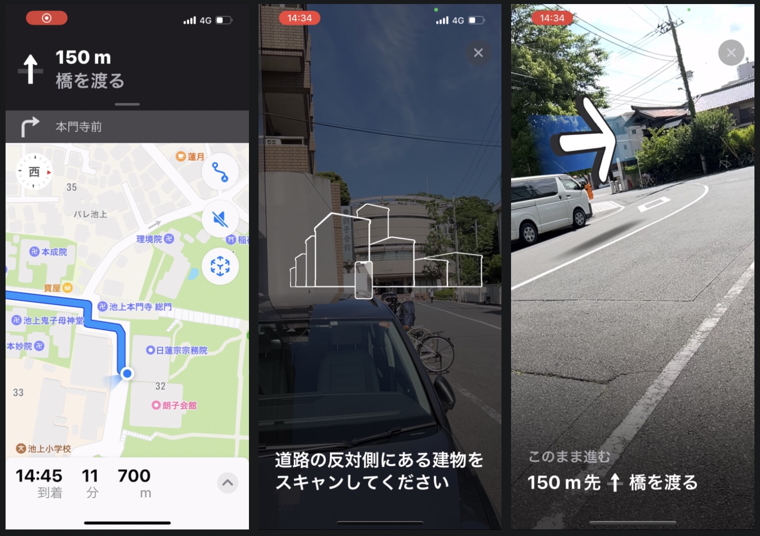
In iOS 15, Apple's Maps app includes the ability to use augmented reality walking directions in some big cities, and today we learn that Tokyo has become the latest place that you can use it.
japan-tokyo-ar-walking-directions-maps.jpg

The AR mode can map walking directions onto the real world by using your iPhone's rear camera, making it easier to see where you need to go in built-up areas and reducing the need to look down at your smartphone as you move.

The feature's availability in Tokyo was discovered by Ata Distance, who also says other Japanese city maps may have been updated beyond Tokyo, but it's hard to know without being on the ground.

To initiate a walking route, iPhone users can raise their ‌device‌ and scan the buildings around them when prompted. The step-by-step directions will appear in the AR mode automatically, which should make it easier to get where you need to go, especially in situations where the directions are tricky.

According to Apple's feature availability page, AR walking directions are available in London, Los Angeles, Montréal, New York Philadelphia, San Diego, San Francisco Bay Area, Singapore, Toronto, Vancouver, and Washington, DC. Japan has yet to be added to the list.

Article Link: Apple Maps Gains AR Walking Directions in Tokyo, Japan
 
  • Love
Reactions: TakeshimaIslands
I tried this out in NYC last year and was pretty impressed. Of course, I couldn't stop watching it as I was walking which you're not really supposed to do..Hah.

Video HERE

I accidentally came across this in New York when getting into Manhattan and looking for my hotel, AR came up. Most iOS users never see these features and it's surprising when they come up in an app you thought you were so familiar with and use every day in your home city.
 
  • Like
Reactions: TouchedByAl
Do they work equally as well in English in Tokyo? Or Japanese in Toronto?

I suspect that I would want names of places, streets, etc. to be in both English and Japanese were I wandering round Tokyo. The English to understand, and the Japanese to compare with signs.
 
  • Like
Reactions: TakeshimaIslands
Nice, but really wish they would do more frequent satellite imagery updates for my area. I know they are using 5+ year old images since I put Solar on my house 5 years ago March and it still doesn't show. Probably doesn't matter in many locations, but I'm in a rapid growth area. What is odd is they use different imagery for the Maps app on MacOS (about 2 years old) vs iOS or iPadOS. GoogleMaps is about a year old.
 
Nice, but really wish they would do more frequent satellite imagery updates for my area. I know they are using 5+ year old images since I put Solar on my house 5 years ago March and it still doesn't show. Probably doesn't matter in many locations, but I'm in a rapid growth area. What is odd is they use different imagery for the Maps app on MacOS (about 2 years old) vs iOS or iPadOS. GoogleMaps is about a year old.
This is one feature I truly don;t understand...and honestly, haven't looked into that much...but we all know there are companies taking very detailed satellite images of the entire Earth on a daily basis but I'm sure the cost is high, cloudy days, stitching like images together, 3D views which are not satellite necessarily, etc.

My guess is that like LookAround in the USA, Apple is putting together a complete update that will hopefully blow us away like 3D/flyover type satellite across the country....or not...
 
  • Like
Reactions: TouchedByAl
Nice, but really wish they would do more frequent satellite imagery updates for my area. I know they are using 5+ year old images since I put Solar on my house 5 years ago March and it still doesn't show. Probably doesn't matter in many locations, but I'm in a rapid growth area. What is odd is they use different imagery for the Maps app on MacOS (about 2 years old) vs iOS or iPadOS. GoogleMaps is about a year old.
It'd be cool to have quicker updates for all map data in general. When you look at the map imaging schedule, it's just a year carved out, at least for most of the US.
 
It'd be cool to have quicker updates for all map data in general.
From a UK point of view, it might actually make sense for local authorities to offer a service to Apple, Google, and anyone else interested than for the companies to collect update information themselves.

Almost all things like changes to roads, new buildings, etc., pass through one part or another of our local authorities. From planning and building control, highways, pavements, etc.

If they offered to supply changes information to these companies, everyone could benefit. The councils would get another modest income stream. The companies could keep their maps better updated. The map users would receive more accurate information.

They could even supply information about roadworks, etc., from known issues and planned works.

Of course, the big companies would probably still do their own major surveys from time to time. And they might decide to use the local authority data to identify where new surveys are required.
LA's can't even fill potholes from the constant diggin' up by all the utilities multiple times a year which they can't co-ordinate.
The tech is what differentiates Google from Apple et al, with a LA doing it there'd just be another standard that's hamstrung by whatever tech they'd outsource, you'd be lucky to get a pic let alone multiple for street view / look around, plus it's all the other data that Google & Apple sniff when they're doing it, never going to happen nor is it viable.
 
Do they work equally as well in English in Tokyo? Or Japanese in Toronto?

I suspect that I would want names of places, streets, etc. to be in both English and Japanese were I wandering round Tokyo. The English to understand, and the Japanese to compare with signs.

Most streets don't have names in Tokyo, so that's not really an issue. Apple maps (and Google, for that matter) already lists place names in English (romanized). I'll try out the AR walking thing later this weekend maybe.
 

Attachments

  • IMG_542A7B87BDAC-1.jpeg
    IMG_542A7B87BDAC-1.jpeg
    272.6 KB · Views: 964
I can tell you it is still behind the times with lack of public Wi-fi and places that accept Apple Pay. I’m excited to try this this weekend and hope one day it will work inside buildings too
I'm not sure where you live or the areas you frequent, but I don't have that experience at all in Tokyo.

I take trains and busses every day, and many of them have public wi-fi (though IIRC Toei stopped wi-fi service on their busses a few months ago). Many phone booths also advertise public wi-fi. NTT even has an app to help you find public wi-fi spots. But data plans are so cheap these days that I wouldn't really want to risk using it (20GB for ~¥2,000/mo with Rakuten [free for the first year!], and others are close).

I use Apple Pay regularly on apps like Wolt or Demaecan, and the NFC payment tied to my credit card (does that count as Apple Pay?) every single day at the conbini or the grocery store. The only places that don't have these days are small mom & pop stores, vending machines, and the kiosks inside train stations (they take PASMO or Suica, so basically a non-issue).
 
Register on MacRumors! This sidebar will go away, and you'll see fewer ads.