The maps app on the iPhone used to only show traffic on motorways and very main roads, but I noticed recently that it's started showing traffic info for all sorts of roads.
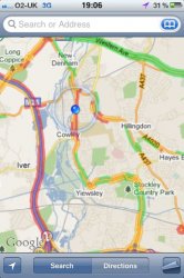
However, this information is always wrong. In the attached picture (where I was avoiding trouble on the M25) I was apparently in a load of 'red'. I was, literally, the only car on that stretch of road.
So, how does the iPhone get its information?
However, this information is always wrong. In the attached picture (where I was avoiding trouble on the M25) I was apparently in a load of 'red'. I was, literally, the only car on that stretch of road.
So, how does the iPhone get its information?