My old garmin had my house in London 300 metres below sea level. I live next to the Thames. I don’t trust watch/gadget based “altimeters”
Got a tip for us?
Let us know
Become a MacRumors Supporter for $50/year with no ads, ability to filter front page stories, and private forums.
Apple Watch May Display Incorrect Altitude Readings in Unusual Weather Conditions
- Thread starter MacRumors
- Start date
- Sort by reaction score
You are using an out of date browser. It may not display this or other websites correctly.
You should upgrade or use an alternative browser.
You should upgrade or use an alternative browser.
And read about the locals that were going up there to remove the many bodies. So many have died, and many don't make the news at all. Hundreds at least. Sad...Yes, it really depends on the individual. Look at the people that summit Mt. Everset with no canned O2
Yes, very true. It is sad.And read about the locals that were going up there to remove the many bodies. So many have died, and many don't make the news at all. Hundreds at least. Sad...
it would not work in a pressurized airplane as it would only report cabin altitude which is around 6,000 to 7,000 feet. The plane's altimeter is ported to outside air (static source) so it reports based on outside air pressure.I have to admit to ignorance here...I had not realized the was even there. That is cool, I wonder if it would work in an airplane?
FAA regulations allow continuous flight at 12,000' with no supplemental O2. Between 12,500' and 13999' you can be there for up to 30 minutes with no supplemental oxygen.Planes that have experienced a loss of cabin pressure dive to at or below 10,000 feet before the pilots can take off their oxygen masks. I was referring to that altitude in my comment. Yes, there is oxygen at even higher altitudes, but it's the percentage of oxygen, the volume (partial pressure) that they are looking for. Any hint of hypoxia can interfere with the brains functions, making snap decisions and evaluating emergency situations prone to be made in error. So while you are correct, the regulations, and physics, err on caution.
The altimeter in civilian aircraft is about the same price as an Apple watch and all it does is measure outside air pressure. It is essentially a barometer. And despite the fact that it can be easily calibrated for changes in barometric pressure associated with weather changes, our expensive altimeters can often be in error by 20 to 50 feet.
Note, although barometric pressure drops by 1" Hg every thousand feet of climb, we set our altimeters to a pressure setting that is referenced to sea level pressure. Standard pressure at sea level is 29.92" Hg or 1013 mb which is a pressure of 14.76 psi.
Note, although barometric pressure drops by 1" Hg every thousand feet of climb, we set our altimeters to a pressure setting that is referenced to sea level pressure. Standard pressure at sea level is 29.92" Hg or 1013 mb which is a pressure of 14.76 psi.
And, based on what I have seen in videos and posting by a pilot/trainer (does pilot training for airlines) "www.mentourpilot.com" supplemental O2 is only for 12 minutes, allowing the pilot to decent to safer altitudesFAA regulations allow continuous flight at 12,000' with no supplemental O2. Between 12,500' and 13999' you can be there for up to 30 minutes with no supplemental oxygen.
He has a YouTube channel and an Instagram page and posts very informative and cools stuff.
Two questions. Are professional European football fields a standard size, and aren’t they called a pitch not a field? Bonus question. Would a European ever reference American soccer as a unit of measurement?
i dunno, I’m American lol
I talked to a Hungarian about this after I posted and she said it was called a pa'lya (I can't don't know how to type the a with the comma on top) which she said also means trajectory but wasn't sure how close the definitions were related. Then she laughed at me because we still measure things in hands and hammers and also because I made a comment about how a building constructed in 1848 was old.What’s American soccer, is it different from standard association football?
Technically it is called field of play, but I think the English now refers them as pitch. In Germany they would call it feld. In other languages something different. The size is around 100-110x75-85 m. I have only heard of the use in describing areas, not lengths, which is typically measured in Eiffel towers. 😋
The around part confuses me. Is it like baseball stadiums where they can be any size they want, or do they just have to be a specific area and the length and widths don't directly matter?
„Apple says that its updated altimeter cross-references information from GPS and nearby Wi-Fi networks to detect even the smallest changes in elevation above ground level, up and down to the measurement of 1 foot.“
Nonsense. I have the altimeter readings as a complication on my watch face, because I find it interesting to look at on a hike and it's also a shortcut to the compass. According to my Apple Watch, my home moves up and down dozens of feet depending on the day. It is not nearly precise to 1 foot. It might give you a general idea around a 100 foot of precision.
I actually just moved up 1 foot sitting in my chair writing this according to my Apple Watch.
It's a nice thing to play around with but it is not nearly as precise as Apple's marketing makes it out to be. Not even close.
I'd guess that recalibration does depend in part on local weather data. It seems likely that a temporary interruption/corruption of that data could be responsible for the inaccuracy.If there is a data connection, the local time sensitive barometric pressure at ground level should be used for correction to improve accuracy. If not, it should be indicated as not corrected for local pressure and allow for a manual entry temporarily until data is available and updated. Also, I presume the measurement is in AGL and not MSL.
As to whether end-users should have a manual recalibration feature... One more setting to be mis-used by some, confuse others, and otherwise add to the complexity of products that are unbelievably complex to begin with. Those who can make knowledgable use of calibration/adjustability will be in the small minority. If I had to recalibrate before every walk/hike I take... forget about it!
While "It just works" can lead to the binary opposite at times, on the balance it's going to work more reliably, with greater satisfaction for end-users, than the do-it-yourself alternative. It's why I have total faith that, once "perfected," autonomous vehicles will be far superior to today's "loose nuts behind the wheel." And occasionally there will be an error, and as always, there will be those who then rush in to assert the superiority of human over machine.
GPS that is accurate to at best +/- 30 feet, triangulation to known cell towers and wifi networks that depends upon being in an area that has numerous towers and networks, low-cost pressure transducers, timely local weather data... Since that data must be updated/refreshed to be useful, communications failures (whether local connections between Watch and iPhone or Watch/iPhone and the internet, or a crashed weather or geographic data server) "garbage in, garbage out" can throw a wrench into the works. While one can easily know the coordinates of "Home," once you're away from a precisely-known geophysical benchmark, all bets are off. Change of elevation is more likely to be accurate than absolute elevation.
A Watch altimeter is not exactly "laboratory-grade instrumentation." Just accept it for what it is.
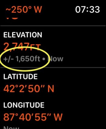
After I first took my Series 6 in a few flights with a maximum (pressurized) cabin of around 8000 feet, it started indicating around 2000 feet too high, with the error at +/-1650 feet. The only way to fix the problem temporarily was to unpair and re-pair the watch. Talked to Apple on the phone and chat, very frustrating as none of the reps seemed to understand how a barometric altimeter works.
I gave up on trying to figure it out. Fast forward a few weeks after several more flights, the altimeter is indicating a reasonable altitude with the error varying between +/-20 and +/-120 feet. Looks like it is 'learning', or calibrating itself.
Definitely room for improvement.
I gave up on trying to figure it out. Fast forward a few weeks after several more flights, the altimeter is indicating a reasonable altitude with the error varying between +/-20 and +/-120 feet. Looks like it is 'learning', or calibrating itself.
Definitely room for improvement.
Attachments
Last edited:
Every aircraft with an altimeter does a calibration on the tarmac prior to takeoff. Things like Density Altitude, weather fronts, temperature changes all affect the altimeter. With Apple products also getting time, temperature and GPS locations updated very often, I would think that a re-calibration of sorts would simply be a matter of aligning your GPS location to that of the nearest airport, and using that known elevation as a baseline.
A similar problem exists with how they calibrate flights climbed, or maybe it just doesn't work as well over time. I hike the same 500 ft. elevation climb every Sunday, but it suddenly started shortly me 200 feet in climb every week, then jumped back up and again back down. I assume the mechanism is different between the watch and the phone, but it is annoying knowing that it is not correctly counting my exercise.
Apple says that its updated altimeter cross-references information from GPS and nearby Wi-Fi networks to detect even the smallest changes in elevation above ground level, up and down to the measurement of 1 foot.
GPS isn't even accurate to a foot in the horizontal, and the vertical is worse. And this is a watch, so it's going to do worse than a "quality" GPS. I'd be surprised if the GPS in your watch would get altitude better than 10-20m in the vertical directly. WiFi would be even worse...
Part of the problem is that people think altimeters measure altitude. They really don't. They measure air pressure. To derive an altitude from pressure, you need outside information–typically the local atmospheric pressure. There are no doubt some tricks Apple could do to improve the altimetry using GPS position and altitude information, but those would have to be coded into the software. Maybe the altimeter will improve with subsequent iOS/WatchOS versions.
Yeah, barometry is basically used to measure short term changes in altitude and it's filtered by another source that's stable over the longer term (like GPS).
Do Europeans measure distance in sports venues?
For those who don't understand the joke, they're referring to the fact that when you see an American measurement written as, for example, 4' 3", it means "4 football fields and 3 basketball courts".
Wasn't it this kind of mixed units that crashed that Mars probe?Would a European ever reference American soccer as a unit of measurement?
Are Apple Watches priced at $1,355? I didn't know they were so expensive. Everything dealing with aviation is expensive. That FAA TSO certification isn't cheap.The altimeter in civilian aircraft is about the same price as an Apple watch and all it does is measure outside air pressure. It is essentially a barometer. And despite the fact that it can be easily calibrated for changes in barometric pressure associated with weather changes, our expensive altimeters can often be in error by 20 to 50 feet.
Note, although barometric pressure drops by 1" Hg every thousand feet of climb, we set our altimeters to a pressure setting that is referenced to sea level pressure. Standard pressure at sea level is 29.92" Hg or 1013 mb which is a pressure of 14.76 psi.
You can buy altimeters for about $500 that are not TSO'd. There's little difference in accuracy.Are Apple Watches priced at $1,355? I didn't know they were so expensive. Everything dealing with aviation is expensive. That FAA TSO certification isn't cheap.
You can buy altimeters for about $500 that are not TSO'd. There's little difference in accuracy.
I thought you said 'used in airplanes'. In order to be used in an airplane, installed in one, doesn't it have to meet FAA standards? I had one that was portable, but I don't think I'd depend on it in IFR conditions. *shrug*
Not sure how you got laboratory grade and calibration out of what I said. I said local and time sensitive barometric pressure should be used for correction. I said nothing about accuracy or certification. If I’m off the grid data wise and want to record my activity I should be able to enter a local baro pressure if I have a source like a NOAA weather radio... or go into my workout record after and correct the baro data that was used to generate altitude at the time.I'd guess that recalibration does depend in part on local weather data. It seems likely that a temporary interruption/corruption of that data could be responsible for the inaccuracy.
As to whether end-users should have a manual recalibration feature... One more setting to be mis-used by some, confuse others, and otherwise add to the complexity of products that are unbelievably complex to begin with. Those who can make knowledgable use of calibration/adjustability will be in the small minority. If I had to recalibrate before every walk/hike I take... forget about it!
While "It just works" can lead to the binary opposite at times, on the balance it's going to work more reliably, with greater satisfaction for end-users, than the do-it-yourself alternative. It's why I have total faith that, once "perfected," autonomous vehicles will be far superior to today's "loose nuts behind the wheel." And occasionally there will be an error, and as always, there will be those who then rush in to assert the superiority of human over machine.
GPS that is accurate to at best +/- 30 feet, triangulation to known cell towers and wifi networks that depends upon being in an area that has numerous towers and networks, low-cost pressure transducers, timely local weather data... Since that data must be updated/refreshed to be useful, communications failures (whether local connections between Watch and iPhone or Watch/iPhone and the internet, or a crashed weather or geographic data server) "garbage in, garbage out" can throw a wrench into the works. While one can easily know the coordinates of "Home," once you're away from a precisely-known geophysical benchmark, all bets are off. Change of elevation is more likely to be accurate than absolute elevation.
A Watch altimeter is not exactly "laboratory-grade instrumentation." Just accept it for what it is.
Not sure how you got laboratory grade and calibration out of what I said. I said local and time sensitive barometric pressure should be used for correction. I said nothing about accuracy or certification. If I’m off the grid data wise and want to record my activity I should be able to enter a local baro pressure if I have a source like a NOAA weather radio... or go into my workout record after and correct the baro data that was used to generate altitude at the time.
Strava has a feature where it will use the bike computer 'altitude' to show what I've ridden by default. Sometimes it's 'a little off'. They have a button allowing the 'altitude' to adjusted to the 'official' topological data for the route I rode. Sometimes the difference is minuscule, other times, it's pretty large. It's funny to see hills disappear, or appear. To see a ride go flat is funny. But many of the routes I ride are heavily forested, which blocks the GPS signal making measurements sketchy. I think my bike computer also has an altimeter. I'd still rather trust the GPS system.
My first experience with a Garmin Edge was without using their speed sensor, and due to the spotty GPS coverage, I would also have erratic speeds shown too. Occasionally spiking to near inhuman levels. Hah... So the data is only as good as the input.
Local pressure can vary from location to location, but not nearly enough to be wildly inaccurate. It can vary quite a bit throughout the day too. Getting, and setting the current barometric pressure would be one of the last things I'd want to do before going out on a telemetered routine, but having the computer miss part of a ride? It's war!!!😆😆😆
I'd guess that recalibration does depend in part on local weather data. It seems likely that a temporary interruption/corruption of that data could be responsible for the inaccuracy.
As to whether end-users should have a manual recalibration feature... One more setting to be mis-used by some, confuse others, and otherwise add to the complexity of products that are unbelievably complex to begin with. Those who can make knowledgable use of calibration/adjustability will be in the small minority. If I had to recalibrate before every walk/hike I take... forget about it!
While "It just works" can lead to the binary opposite at times, on the balance it's going to work more reliably, with greater satisfaction for end-users, than the do-it-yourself alternative. It's why I have total faith that, once "perfected," autonomous vehicles will be far superior to today's "loose nuts behind the wheel." And occasionally there will be an error, and as always, there will be those who then rush in to assert the superiority of human over machine.
GPS that is accurate to at best +/- 30 feet, triangulation to known cell towers and wifi networks that depends upon being in an area that has numerous towers and networks, low-cost pressure transducers, timely local weather data... Since that data must be updated/refreshed to be useful, communications failures (whether local connections between Watch and iPhone or Watch/iPhone and the internet, or a crashed weather or geographic data server) "garbage in, garbage out" can throw a wrench into the works. While one can easily know the coordinates of "Home," once you're away from a precisely-known geophysical benchmark, all bets are off. Change of elevation is more likely to be accurate than absolute elevation.
A Watch altimeter is not exactly "laboratory-grade instrumentation." Just accept it for what it is.
It's basically 'an educated guess'. Planes have crashed because the ports for the various external sensors have been painted over, or covers haven't been removed. The 737 MAX crashes were kind related to that. The system only had one sensor, and when that sensor wasn't working, the system was programmed to take a 'drastic' action. Most plane systems operate with redundancy, where if one system isn't working or indicating correctly, another one will take over, or be available. Many pilot/co-pilot instruments are not connected to each other to allow for backup in case one system 'screws up'. The argument between the two systems has actually caused crashes too, tragically.
I just trust that the GPS system tells me I'm where I am, and not riding the Himalayas.

Yes! This is exactly what has happened to me. In late December, I flew from Northern California to Santa Fe, New Mexico- so, from about 150ft elevation, to around 6,500 ft. Out of curiosity to see what the airplane cabin was pressurized at, I opened my watch compass app. After I landed, my watch was forever stuck at least 1,500ft above my actual elevation. Device restart, restore from backup, and factory resets did not fix the issue. Next, after multiple calls with Apple care, they had me do some steps to try to “re-calibrate” the watch this involved setting the workout app to run, walk, or hike mode, and going for one of those activities for 30+ minutes, multiple tiles throughout the week. They said this should help the watch re- calibrate. It didn’t work. Finally they sent me a new watch. This weekend, I traveled to Santa Fe again. Once again, I repeated the same process on the airplane, wanting to see if I could replicate the issue on a new device. my watch is now off 2,500ft. Saying I am at 9,050ft, when in reality, I’m at about 6,500. It says I have an accuracy of +/- 530ft.I’ve been flying a lot recently and after my last flight my Apple Watch is stuck at ~2450 ft when I’m maybe 50 ft above sea level. Previous to this the altimeter seemed very accurate.
I wonder if the altimeter has broken some how. It says it has an error of ~1500 ft. It’s been like this for a week, tried restarting the watch, ejecting water.
Not sure if this is a hardware issue or a software issue, but I’d sure love to be escalated to a senior engineer so we can get this figured out. I’m an avid hiker, and love tracking my altitude overall as well as altitude gained/ lost. This is a big issue for active outdoor use cases.
Has anyone had any luck resolving a similar issue?
I think some of the problems here is that a 'barometric altimeter' is measuring the atmospheric pressure, and making an assumption based on the general relationship between increased altitude and decreased atmospheric pressure. It's very likely a small physical device that measures the pressure.
Being a physical device, the sensor can be damaged, or even forced out of compliance. And extreme changes could render the pressure sensor unable to function, or register changes in pressure properly.
What technology could perform that function better? Well, GPS, or more generally a 'satellite location system'. But they aren't truly accurate due to an array of extenuating circumstances, but should be more accurate than a simple mechanical barometric altimeter.
So if the Apple Watch relies on the physical sensor, it really could be thrown off, or left unable to register the proper 'altitude'. I'm not surprised that flying can distort, or ruin a barometric altimeter that was meant to be on the ground with the rest of us. Being a diver, I was warned about certain depth guages, and that altitude could ruin them. Most 'modern age' depth guages are likely immune to that now.
As an aside, that is why pilots change to a set 'altitude' over a certain registered altitude. Why? You don't want two planes flying at different altitudes to be flying at the same physical altitude. Accidents and other mayhem would for sure happen. That's why 'altitudes' while flying commercial planes are called 'flight levels'. Everyone has the same set point for their barometric altimeter, so they *should* all be showing the same physical altitude. As the plane descends, they change the set point for the altimeter to the local barometric pressure. Cool, huh...
Register on MacRumors! This sidebar will go away, and you'll see fewer ads.