Become a MacRumors Supporter for $50/year with no ads, ability to filter front page stories, and private forums.

MacRumors

macrumors bot
Original poster
Apr 12, 2001
63,558
30,889


Apple appears to be gearing up to add topographic maps to the Apple Maps apps in iOS 18, macOS 15, and visionOS 2, according to code reviewed by MacRumors.

watchos-10-maps-app.jpg

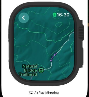
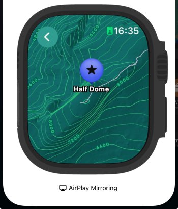
First introduced with watchOS 10, topographic maps include trails, contour lines, elevation, and points of interest, features that are of use for hiking and other outdoor activities where accurate navigation is essential.

Since debuting topographic maps, Apple has been expanding support throughout the United States, and this year, Apple may be ready to bring it to iOS, macOS, and visionOS.

Backend topographic maps code was introduced last year, but only watchOS 10 had the feature. The code was dormant on iOS and macOS at that time, but in the backend files for iOS 18, macOS 15, and visionOS 2, the code is active, suggesting an expansion.

The possibility of topographic maps follows our report yesterday on another possible Apple Maps feature, support for custom routes. With custom routes, users will presumably be able to create their own routes without being limited to Apple's pre-selected options.

‌iOS 18‌ will be introduced at the Worldwide Developers Conference on Monday, June 10, and it appears there will be quite a few new features for Apple Maps. For more details about the update, check out our iOS 18 roundup.

(Thanks, Nicolás!)

Article Link: Apple Watch Topographic Maps Could Expand to iPhone in iOS 18
 
  • Like
Reactions: SFjohn

marmiteturkey

macrumors 6502a
Aug 27, 2005
911
1,013
London
Didn’t even know this existed. I just checked my Apple Watch and yes, there is a Maps app on there 🤯
Fascinating how we all use these devices so differently!
Watch maps app is one of my must-haves, I use it constantly to navigate around London.

That said, I’ve never seen topo data on watch maps…
 

mansplains

macrumors 6502a
Jan 8, 2021
855
1,331
Since debuting topographic maps, Apple has been expanding support throughout the United States
That said, I’ve never seen topo data on watch maps…
I haven't seen any either. I was in Death Valley and Zion NPs recently and expected some data, at least in CA. It would be really nice to have, living in CO and frequenting the Rockies.

Edit: The compass app gained some elevation tracking with waypoints too. The new waypoints for cell reception and SOS are really nice, Death Valley has no service.

Edit 2: I actually do see the topo data! I guess I didn't have maps zoomed in far enough, it's odd you can't be zoomed out more.
 

Attachments

  • IMG_1994.jpeg
    IMG_1994.jpeg
    539.5 KB · Views: 123
Last edited:
  • Like
Reactions: LightProtector

lenger

macrumors newbie
Mar 25, 2024
19
23
Nice update but mostly lost on me. There is no topographical relief to speak of where I live (NL) :p. Still keeping my fingers crossed for cycling directions in Maps in the near future.
 
  • Like
Reactions: TheMountainLife

mansplains

macrumors 6502a
Jan 8, 2021
855
1,331
Does it work in Yosemite?
I wish I could say. Unfortunately, Yosemite was out of reach, given the 8hr drive to the entrance opposite of DV. We were at DV for the super bloom, which didn't happen this year.

Edit: Yes, it appears to work throughout Yosemite. I found that I wasn't zoomed in enough.
 

Attachments

  • IMG_1995.jpeg
    IMG_1995.jpeg
    743.5 KB · Views: 294
Last edited:

mansplains

macrumors 6502a
Jan 8, 2021
855
1,331
Yes! This would be huge. Didn't ever make much sense to have such a useful map mode restricted to the tiniest possible screen. Can't wait for this!
My thoughts exactly. The watchOS compass app needs to make its way to iOS as well. It is very cumbersome to edit waypoints on AW, and the current iOS compass app leaves a lot to be desired.
 
  • Like
Reactions: LightProtector

cjcampbell

macrumors member
Jan 25, 2008
33
14
This will be a big deal here in southern Utah where people seem to spend most of their lives in outdoor activities.
 
  • Love
Reactions: gusmula

TypeMRT

macrumors 6502a
Sep 7, 2007
525
130
The walking radius is useless - almost dangerously so - for hiking. The estimate is based on traversing an infinitely flat ground. Even the Apple screenshot shows a walking time estimate of about 6 minutes to hit almost 1000 feet of elevation gain. Hopefully someone at Apple decides to actually go outside and try to use the topo map view for hiking trails before porting it to iOS.
 

jclardy

macrumors 601
Oct 6, 2008
4,161
4,376
Would be cool to get 3d topo maps in visionOS. Check out hiking trails in the headset then send them to the watch.
 
Register on MacRumors! This sidebar will go away, and you'll see fewer ads.