Become a MacRumors Supporter for $50/year with no ads, ability to filter front page stories, and private forums.

MacRumors

macrumors bot
Original poster
Apr 12, 2001
65,232
33,509


Google today announced that it is expanding transit crowdedness predictions to more than 10,000 transit agencies in 100 countries so that customers can better determine which transit options are at capacity and which have more open space and seating available.

transit-crowdedness-google-maps.jpg

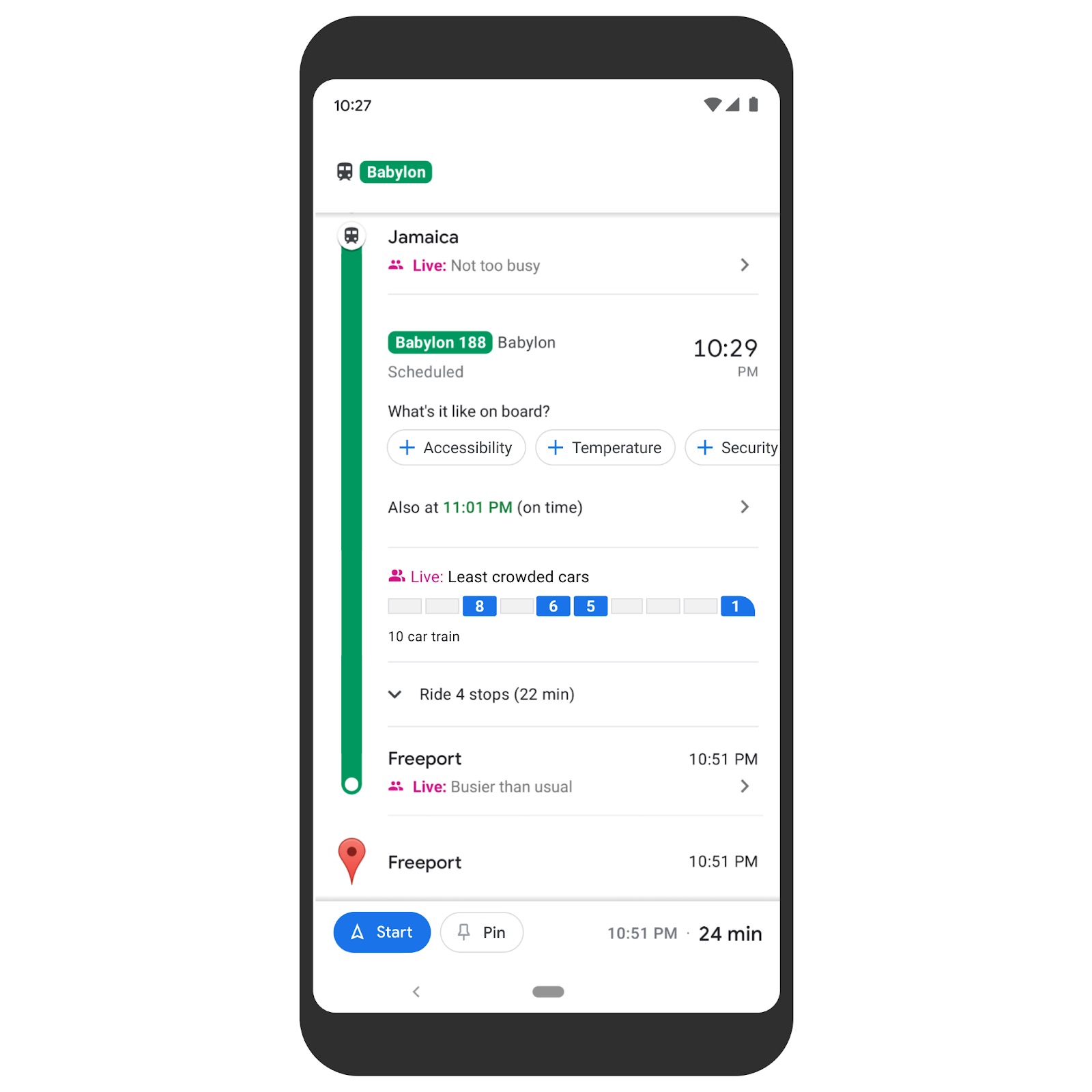
In New York and Sydney, Google is launching a pilot program that lets Maps users see live crowdedness information at the transit car level, with the feature powered by the Long Island Rail Road and Transport for New South Wales.

Google is also updating its review process to make it easier for Google Maps users to leave detailed reviews. The review interface will prompt users to add information like price ranges or whether a restaurant offers takeout or delivery.

For Android users, Google has added a new Timeline Insights tab that's designed to provide details on modes of transportation used, miles traveled, and how much time has been spent at different places like shops, airports, and restaurants.

A Trips feature, also available on Android, lets users relive past trips that they've taken by resurfacing restaurants visited, hotels stayed in, and more. There is no word on whether Timeline Insights or Trips is coming to iOS, but these features require detailed Location History.

Google Maps for iOS can be downloaded from the App Store for free. [Direct Link]

Article Link: Google Maps Gains Expanded Transit Crowdedness Predictions
 

sflagel

macrumors regular
Jun 28, 2012
209
360
I can already provide this info to anyone who cares for London: Trains are Full to the Brim. Always. TfL reduces the number of trains when its less busy so that even then, the trains are full.
Buses on the other hand (those terrible double sized red monsters that, together with Ubers, cause 50% of the intolerable traffic here) are always empty.
 

Oohara

macrumors 68040
Jun 28, 2012
3,050
2,423
And yet still I cannot get biking directions on Apple Maps.
Apple Maps is still woefully behind in so many areas. I'd love to use it more since it's so integrated into the Apple ecosystem, but Google Maps remains my go-to. Just the other day I gave Apple Maps another chance and it sent me on an unnecessary 20 minutes walk in the heat because it didn't know a walking path that Google Maps had down. Not surprising since Google has been at it for so much longer and in a much more extensive way, but I hope Apple eventually finds a way to catch up with their map feature.
 

ArtOfWarfare

macrumors G3
Nov 26, 2007
9,597
6,116
How do they get this data? Is there an AI watching some video feed to decide, or are there weight sensors, or something else? Maybe just a sensor at the door that's counting how many people get on/off, with additional guesses based on how quickly people clear the doorway?
 
  • Love
Reactions: peanuts_of_pathos

velocityg4

macrumors 604
Dec 19, 2004
7,330
4,721
Georgia
How do they get this data? Is there an AI watching some video feed to decide, or are there weight sensors, or something else? Maybe just a sensor at the door that's counting how many people get on/off, with additional guesses based on how quickly people clear the doorway?

I'd expect it goes by tracking android users or Google maps users in the vicinity over time. When they get there, when they leave, where they go, &c. To build a model of number of people to expect on any given time and day.

I'd like to think this is based off data of those who allow location tracking only. Averaged by percent of users who don't disable tracking and use a trackable Google App (like maps on iPhone) or an Android device.

At any rate. They should have pretty accurate data on percent of people in any given region they can't track. To model how many are likely to use the various metro transit services at any given time of day, day of the week, holidays and so forth.

Maybe they also have deals with the various transit authorities to track entries and departures through the turnstiles. But the phone data would augment this. By tracking from home, to parking or bus, to train/subway, to bus, &c.

They'd also know how many trains are running. Number of cars on train. Capacity of the trains. How long people are standing around waiting for a train.
 
  • Love
Reactions: peanuts_of_pathos

mashdots

macrumors 6502
Dec 10, 2015
343
973
seattle-ish
Interesting, but creepy. All your info at others’ fingers tips. Year of hard labour squeezing us like lemons. All android phones going back to papa
Jaaayyyzzzzuuuuzzz

It's possible similar techniques to estimating traffic congestion in maps is being used here. I have no data to back this up but I'm just speculating.

And yet still I cannot get biking directions on Apple Maps.
Apple Maps isn’t even smart enough to auto route. While on freeway a few cities away from destination it kept directing to take surface street.

So interesting to hear experiences from others with maps. Biking (or even driving) in Seattle works really well with maps for me. I don't even have google maps on my phone at this point.
 
  • Love
Reactions: peanuts_of_pathos

Westside guy

macrumors 603
Oct 15, 2003
6,403
4,269
The soggy side of the Pacific NW
Google Maps / Waze is the one Google offering I can't seem to get away from. I'd love to move wholesale to Apple Maps - I prefer the way it gives directions, honestly - but it does bizarre things just often enough that I can't really rely on it.

  • Apple Maps has told me that the fastest route for a ~ 30 minute drive is going to take 5-6 hours, on several occasions.
  • With 15 minutes left on a drive, I've had Apple Maps suddenly add a couple hours to the time remaining and try to offer a bizarre changed route that'll "save 40 minutes" - that's fun to deal with when driving.
I work in Seattle, so I'd expect it to do better than that.
 
Register on MacRumors! This sidebar will go away, and you'll see fewer ads.