Become a MacRumors Supporter for $50/year with no ads, ability to filter front page stories, and private forums.

MacRumors

macrumors bot
Original poster
Apr 12, 2001
67,581
37,970


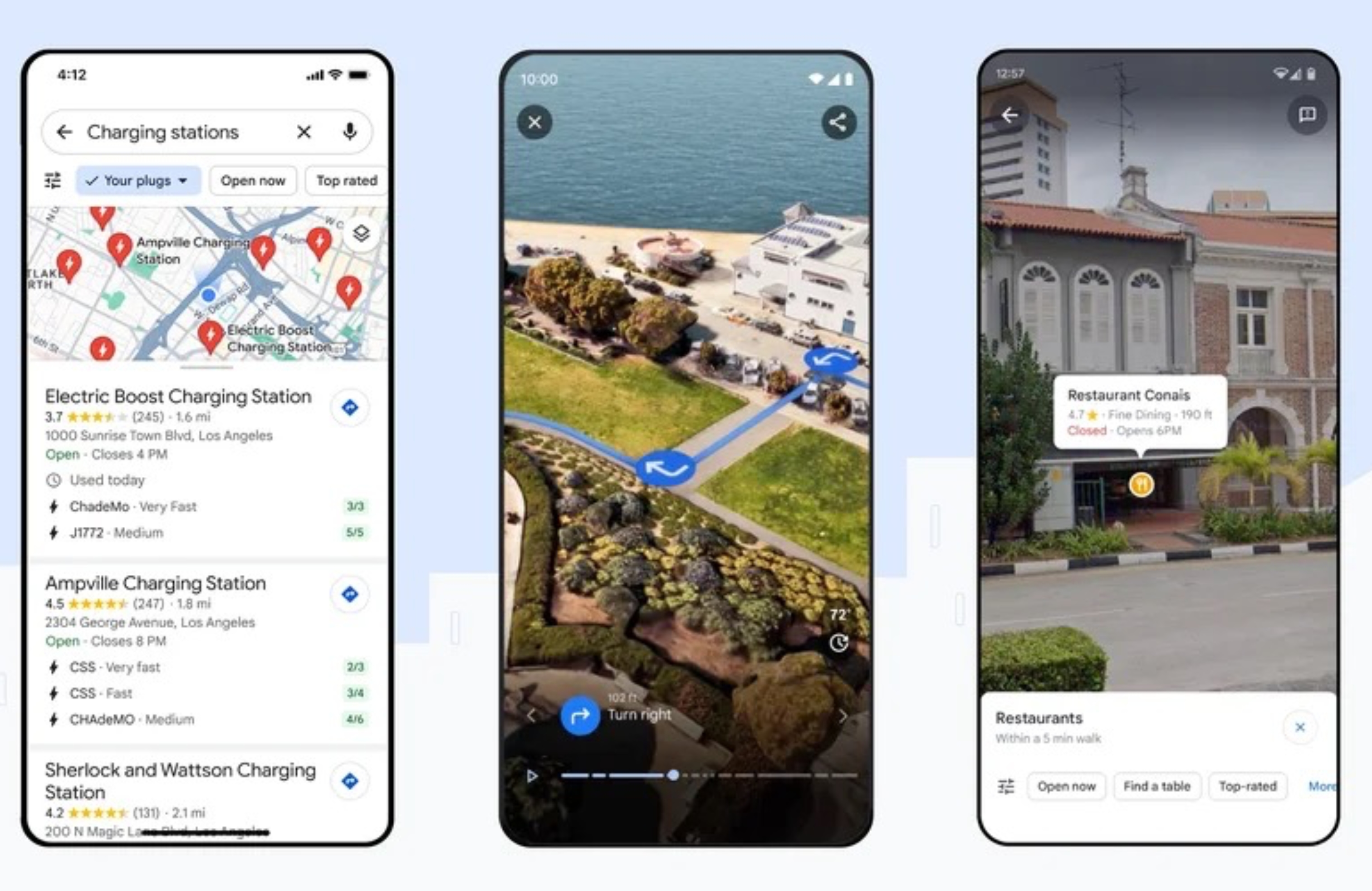
Google Maps is getting a new Immersive View for routes that uses artificial intelligence, Street View, and aerial images to preview every step of a journey ahead of time.
google-maps-immersive-view-routes.jpg

When users get directions for driving, walking, or cycling, Google Maps now offers a "multidimensional experience" that can be used to preview bike lanes, sidewalks, intersections, and parking along the route, according to Google.

A time slider can be used to see air quality information and how the route looks as the weather changes throughout the day, while AI and historical driving trends simulate how many cars might be on the road at a given time.

Immersive View for routes is rolling out in Amsterdam, Barcelona, Dublin, Florence, Las Vegas, London, Los Angeles, Miami, New York, Paris, San Francisco, San Jose, Seattle, Tokyo and Venice on Android and iOS.

In addition to Immersive View for routes, Search with Live View is being replaced with Lens in Maps, which uses AI and augmented reality to help users orient themselves in a new neighborhood.

Tapping the Lens icon in the search bar and lifting your phone now gives you AR-delivered information about nearby ATMs, transit stations, restaurants, coffee shops, and stores. Google says Lens in Maps is rolling out to more than 50 new cities including Austin, Las Vegas, Rome, São Paulo and Taipei.

Elsewhere, the navigation map is getting updated colors, more realistic buildings, and improved highway lane details. These updates start rolling out in the coming months in 12 countries, including the U.S., Canada, France and Germany.

Meanwhile, the U.S. is also set to get information about high-occupancy vehicle (HOV) lanes along a route, and in Europe, AI-powered speed limit information is expanding to 20 countries. Both features start rolling out on Android, iOS, and for cars with Google Built-in in the coming months.

Lastly, Google says EV drivers on Android and iOS will now see even more helpful charging station information, including whether a charger is compatible with their vehicle and whether the available chargers are fast, medium, or slow. This also includes the ability to see when a charger was last used so you know it's not a broken charger. These updates start rolling out globally on iOS and Android this week wherever EV charging station information is available.

Article Link: Google Maps Gains Immersive View for Routes and Other AI Features
 
“…and in Europe, AI-powered speed limit information is expanding to 20 countries.”

This is genuinely cool and useful and I hope that Apple could implement something similar, as currently speed limits in France are not very accurate and change quite frequently due to the road works. Since Apple already use anonymised speed data from a pool of iPhones in the moving cars, it should be reasonably simple for them to calculate an average speed the cars are travelling at for many roads, I guess.
 
  • Like
Reactions: MacsRgr8
“…and in Europe, AI-powered speed limit information is expanding to 20 countries.”

This is genuinely cool and useful and I hope that Apple could implement something similar, as currently speed limits in France are not very accurate and change quite frequently due to the road works. Since Apple already use anonymised speed data from a pool of iPhones in the moving cars, it should be reasonably simple for them to calculate an average speed the cars are travelling at for many roads, I guess.

Average speed and speed limits re different. Average speeds can give a reasonably accurate estimate of time to destination and arrival time; but the average speed may be above or below the speed limit for specific road sections.
 
I’m all in with Apple, but the amount of data that Google has on maps with reviews of places, etc…. Is handy. I find myself using it more and more.

It’s not my default. Wish Apple would copy that aspect and ditch Yelp.
 
Average speed and speed limits re different. Average speeds can give a reasonably accurate estimate of time to destination and arrival time; but the average speed may be above or below the speed limit for specific road sections.
The way it works is that it will detect if the average speed in section of a road suddenly becomes slower or faster than expected and Google will use that information to double check with municipalities and street view imagery to update the speed limit if needed.
 
While it may be better than Apple Maps in various ways, I dislike the UI so much that I'm very unlikely to ever switch back to Google Maps. I do appreciate Google's technological innovation here, though.
 
I’m all in with Apple, but the amount of data that Google has on maps with reviews of places, etc…. Is handy. I find myself using it more and more.

It’s not my default. Wish Apple would copy that aspect and ditch Yelp.

Yelp sucks. Some of the local businesses near me aren't even listed on Yelp. They're on Google, though.

For a while, my house was listed as a business on Yelp, because someone ran a repair shop in my barn back in the 80s to mid 90s. Took FOREVER to get Yelp to remove it.
 
Last edited by a moderator:
  • Like
Reactions: CordovaLark
I’m all in with Apple, but the amount of data that Google has on maps with reviews of places, etc…. Is handy. I find myself using it more and more.

It’s not my default. Wish Apple would copy that aspect and ditch Yelp.
What? I love reading reviews from pretentious "foodies" who give a place that has great food one star because they forgot the eel sauce on their sushi roll.
 
  • Like
Reactions: gund1234
The way it works is that it will detect if the average speed in section of a road suddenly becomes slower or faster than expected and Google will use that information to double check with municipalities and street view imagery to update the speed limit if needed.

Interesting approach, and I think it could be effective at permanent changes since data could be collected over time to finally recognize a pattern. Time of day changes, such as school zone additions, might take longer simply because there are often fewer cars on the road at that time.

Temporary changes, like construction would be harder given the transitory nature, the varying times it is in effect and how well people actually obey a new temporary limit.

I do find it interesting the tag it as AI as if pattern recognition and trend analysis is all of a sudden some new thing.
 
  • Like
Reactions: samlikesmac
Average speed and speed limits re different. Average speeds can give a reasonably accurate estimate of time to destination and arrival time; but the average speed may be above or below the speed limit for specific road sections.

I get it, but if Apple mislabels the speed limit at 90 km/h in a 110 km/h road portion (say, they set it during the road works), then getting a repeated average speed reading of 105-115 km/h from all the cars going through that road portion might allow Apple to gauge the real speed limit and automatically correct it at their end. No need to drive all the Apple cars up and down the country every week then. Magic!
 
  • Want to much more confidently get where you are trying to go? Use Google Maps
  • Want to maybe NOT get where you are trying to go but have a prettier app interface? Use Apple Maps
I keep trying & retrying Apple Maps every few months but instead of coats of ever-prettier paint, they need to get that underlying data cleaned up. I keep wondering why somebody doesn't write an algorithm to plot all points in all major mapping systems and compare where the destinations are plotted. If 4 out of 5 says X but Apple says Y, either flag Y as questionable and seek some community verification for it being right or wrong... or adapt "majority rules."

With a blend of majority rules and some user confirmation, underlying data should clean up quickly so that AM becomes at least as accurate as all others. If it is as accurate AND "prettier", then it can finally be crowned KING. In the meantime, I still want to dependably get where I'm trying to go... and that tends to be much more likely with GM.
 
I already have an amazing multidimensional experience…

Going outside and going for a walk, run or a drive etc

It’s amazing, you wouldn’t believe the resolution, physics and NPC’s… something super powerful must be running this!

I mean the damage models are amazing… even law enforcement are super realistic!
 
Somewhat odd choice of initial cities, but I've recently seen on-foot Google Maps folks combing the streets here in Chicago, so I suspect more cities are on their way.
 
  • Like
Reactions: Fuzzball84
I get it, but if Apple mislabels the speed limit at 90 km/h in a 110 km/h road portion (say, they set it during the road works), then getting a repeated average speed reading of 105-115 km/h from all the cars going through that road portion might allow Apple to gauge the real speed limit and automatically correct it at their end. No need to drive all the Apple cars up and down the country every week then. Magic!
You still can't arbitrarily decide what to display as the speed limit without confirmation though. Google's approach still requires either up-to-date street view data or checking with municipalities before it's reflected in the map data.
 
Why Google or Spotify can release nice features constantly but we have to 1 full year to have anything significant change?.
Even Apple Music does not have “favorites” until the upcoming full IOS release!, why not just push and “app update” as in happens with any app from the App Store???
 
“…and in Europe, AI-powered speed limit information is expanding to 20 countries.”

This is genuinely cool and useful and I hope that Apple could implement something similar, as currently speed limits in France are not very accurate and change quite frequently due to the road works. Since Apple already use anonymised speed data from a pool of iPhones in the moving cars, it should be reasonably simple for them to calculate an average speed the cars are travelling at for many roads, I guess.
It's safe to say I move that average up a good bit. :D
 
I already have an amazing multidimensional experience…

Going outside and going for a walk, run or a drive etc

It’s amazing, you wouldn’t believe the resolution, physics and NPC’s… something super powerful must be running this!

I mean the damage models are amazing… even law enforcement are super realistic!

I hear that version has some kind of smell-o-vision too... and can provide the sounds of the area in real-time. WOW! We should all try that one. ;)
 
  • Like
Reactions: Fuzzball84
Register on MacRumors! This sidebar will go away, and you'll see fewer ads.