Become a MacRumors Supporter for $50/year with no ads, ability to filter front page stories, and private forums.

MacRumors

macrumors bot
Original poster
Apr 12, 2001
68,660
39,536


Google is rolling out some new Maps features to its iOS and Android apps for the summer, including new location sharing options, cycling directions enhancements, and photorealistic aerial views of famous city landmarks.
Google-maps-feaure.jpg

First, location sharing. Google says it wants to make it easier to see when someone who has shared their location with you arrives or leaves a place, "so you can more easily coordinate schedules" and meetups. To that end, it's introducing location sharing notifications, which work similarly to the equivalent feature in Apple's Find My app.

Google offers the following use case:
Say you're headed to a concert with a group of friends. If they've already chosen to share their location with you, you can set a notification for the concert venue's address so you can see when they've arrived and meet up quickly. You could also set a notification to see when they've left the venue — just in case you get split up.
Google says it has built the feature with privacy in mind, which is why notifications can only be set for someone who has already chosen to share their location with you. In addition, that person will receive multiple reminders to let them know they are sharing their location, in the form of push notifications and recurring monthly emails, and users can stop sharing their location anytime.

Next up, Google is adding more granular information to cycling directions in the more than 100 cities where they are available, including things like whether a particular route involves a major or a minor road, if the route suggested includes stairs or steep hills, and when you should be prepared to encounter heavy traffic.
Aerial_Views_of_Landmarks-google.gif

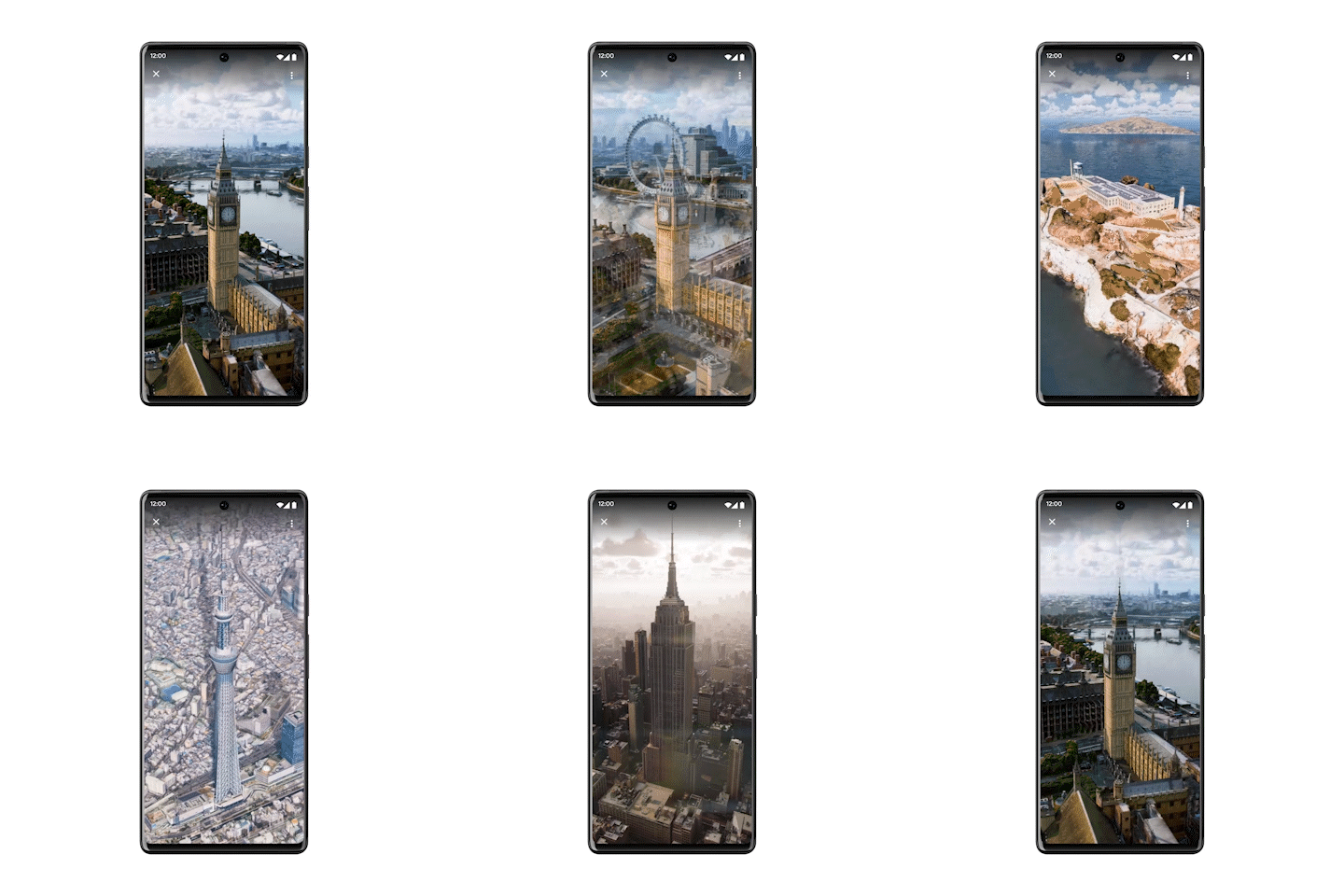
Lastly, Google is bringing photorealistic aerial views of "nearly 100 of the world's most popular landmarks" in cities including Barcelona, London, New York, San Francisco, and Tokyo. Google says the aerial views are a "first step" toward integrating its immersive view feature for cities that the company previewed in May and which is scheduled to roll out later this year.

Google says the aerial views of landmarks and location sharing notifications are rolling out now globally on Google Maps on Android and iOS, with cycling route information launching in the coming weeks in those cities where cycling directions are available.

Article Link: Google Maps Gains Landmark Aerial Views, Location Sharing Notifications for Arrival and Departure, and More
 
It’s the traffic routing for me. Apple Maps doesn’t seem to really know where the traffic is, and even when it does it doesn’t take any evasive action.
My experience is completely the opposite. I often see amber and red line routes ahead as slow or stopped traffic is detected. And, on multiple occasions, I've had Apple maps notify me that a suggested route change will save X minutes.

Perhaps you live in Androidville! Apple infers traffic information by their servers analysing the location of millions of vehicles with iPhones in them.
Google does the same with millions of iPhone users using Google maps.

I wish I could set the default map app to Google maps. It is so much better.
 
Anyone else found Google Maps hangs a lot on their iPhone? I suspect the music player is to blame much of the time.

I’ve found I needed to force quit the App a few times. It’s even fooled me by hanging with Navigation frozen yet still directing me, so I’d drive past where the turn is with the screen frozen from 3 turns ago…
 
My experience is completely the opposite. I often see amber and red line routes ahead as slow or stopped traffic is detected. And, on multiple occasions, I've had Apple maps notify me that a suggested route change will save X minutes.

Perhaps you live in Androidville! Apple infers traffic information by their servers analysing the location of millions of vehicles with iPhones in them.

honestly apple maps has been fantastic both for routes and traffic. Im in the US, that probably makes a difference.
 
honestly apple maps has been fantastic both for routes and traffic. Im in the US, that probably makes a difference.
I’m in the US and in a metropolitan area that typically quickly receives Apple’s latest Maps features. Personally, I find that I prefer Apple Maps’s LookAround feature to Google Maps’s StreetView, I strongly prefer Apple Maps’s transit features, and I prefer Apple Maps’s ground landmarks features to Google’s lack of them. I also find Apple Maps to be great at walking navigation, and I never particularly had an issue with its driving navigation or detour routing suggestions back when I lived in an area where I had to drive more often. I mostly use Google Maps for browsing StreetView in areas where Apple Maps doesn’t have LookAround coverage yet.

As for this 3D aerial view feature, I don’t really use Apple’s equivalent all that often, so I doubt I’d ever use Google’s. Seems like mostly a parlor trick. I’d rather them have spent time, effort, and money on modernizing StreetView imagery. There are still lots of side streets in places, even in the US, where you end up dropped back to 2007-2008 StreetView imagery that looks like it was taken with a potato.
 
  • Like
Reactions: P-DogNC
My experience is completely the opposite. I often see amber and red line routes ahead as slow or stopped traffic is detected. And, on multiple occasions, I've had Apple maps notify me that a suggested route change will save X minutes.

Perhaps you live in Androidville! Apple infers traffic information by their servers analysing the location of millions of vehicles with iPhones in them.
And I'll disagree with you. 🙂

No matter where I drive or cycle Google gives me far superior traffic conditions info.

UK, France, Germany, Greece…

Two weeks ago we were driving to the beach somewhere in the back of beyond in Wales. I saw a solid red line pop up and I thought, oh really? You have to be kidding.

Sure enough… round the bend, there we sat. 30 minutes while some sheep were herded out of the road into a field. There were 5 cars ahead of us. 5 Cars. And yet Google picked it up… now I'm not saying Apple Maps couldn't do that, and I am sure in California it works like a charm, but… 🤷🏻‍♂️

Google does the same with millions of iPhone users using Google maps.

I wish I could set the default map app to Google maps. It is so much better.
100% Agree.

honestly apple maps has been fantastic both for routes and traffic. Im in the US, that probably makes a difference.
I suspect that is the case.

Tracking, I see Tracking, See lots and lots of Tracking.
So if Apple isn't tracking you, I guess that explains why Apple Maps is so *****! 🤣
 
My experience is completely the opposite. I often see amber and red line routes ahead as slow or stopped traffic is detected. And, on multiple occasions, I've had Apple maps notify me that a suggested route change will save X minutes.

Perhaps you live in Androidville! Apple infers traffic information by their servers analysing the location of millions of vehicles with iPhones in them.
I am in the UK, so that may impact things. Certainly, the red bits on Apple Maps is mostly traffic, but there is also traffic where is says there is none.

As for the rerouting, it does give it a crack. But there seems to be a hierarchy of how much rerouting the big 3 are willing to do: Waze is fairly aggressive and will take you miles off track and down country roads to save 5 minutes (I approve!); Google will reroute down main roads; while Apple would rather you sit in traffic than attempt anything adventurous.

I did a week or so of testing about 6 months ago, and I settled on Waze.

Anecdotally, a few years ago I tried TomTom. That is so aggressive!! I loved it. But it had a flaw that they would not acknowledge so I ditched it. If you are interested, please ask!
 
Really puts Apple Maps in the mud.

Every few months I try using it again and it's still nowhere near the functionality or accuracy of Google Maps
I’ve used Apple Maps since the beginning and has never let me down. Google Maps is cluttered and ugly. I can’t look at it for long. Oddly, all of these new features are better on Apple Maps where the were copied from. Lol
 
  • Like
Reactions: P-DogNC
Here In Brazil Google Maps is way ahead in accuracy, but those new features are just gimmicks. The 3d thing is just a poorly made 3D version, that is not even interactive, its just unnecessary.

I really wish Apple Maps would start investing heavily in Brazil, that new detailed maps view on Apple Maps is awesome!
 
Register on MacRumors! This sidebar will go away, and you'll see fewer ads.