When iOS6 Maps came out, it was the only online mapping where the satellite imagery actually showed my house that was built 6 years ago - Google and the others still had the imagery from before it was built.
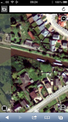
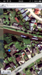
However, if I look on iOS Maps now, my house is no longer showing and the imagery now shows the old house that was there before, in fact it turns out that iOS6 is now using the same imagery as Microsoft's Bing Maps for my town (Bing on the left, iOS on the right below, sadly I've not got a grab of the earlier iOS Maps image which was far more up-to-date). So, has Apple already binned some of it's imagery and switched to another source, or is this just an interim improvement measure until it gets things properly sorted? I can't see Apple wanting to look the same as Bing for long, I guess this is just a short term measure to overcome large areas of the UK being hidden under cloud on the original iOS Maps imagery?
However, if I look on iOS Maps now, my house is no longer showing and the imagery now shows the old house that was there before, in fact it turns out that iOS6 is now using the same imagery as Microsoft's Bing Maps for my town (Bing on the left, iOS on the right below, sadly I've not got a grab of the earlier iOS Maps image which was far more up-to-date). So, has Apple already binned some of it's imagery and switched to another source, or is this just an interim improvement measure until it gets things properly sorted? I can't see Apple wanting to look the same as Bing for long, I guess this is just a short term measure to overcome large areas of the UK being hidden under cloud on the original iOS Maps imagery?
Attachments
Last edited:
