I bought a Garmin DriveSmart 50 since the models I want are out of stock. It is very slow and at the intersection, it gave me the wrong direction. For example, it was supposed to tell me to turn left but it told me to turn right. I read that a gps is good in areas that cellular signals are not available. In big city, is that a problem? Google Map/IOS Map seem to be faster and more responsive.
Got a tip for us?
Let us know
Become a MacRumors Supporter for $50/year with no ads, ability to filter front page stories, and private forums.
Should I buy a GPS or just use an iPhone 6s+?
- Thread starter hajime
- Start date
- Sort by reaction score
You are using an out of date browser. It may not display this or other websites correctly.
You should upgrade or use an alternative browser.
You should upgrade or use an alternative browser.
I bought a Garmin DriveSmart 50 since the models I want are out of stock. It is very slow and at the intersection, it gave me the wrong direction. For example, it was supposed to tell me to turn left but it told me to turn right. I read that a gps is good in areas that cellular signals are not available. In big city, is that a problem? Google Map/IOS Map seem to be faster and more responsive.
Ive been using a navigation app on iPhones for years now. I use TomTom which lets you download the map physically onto the phone, just like your standalone. It works perfectly, seems to be as accurate / more accurate than the cars built in, and is nicer to use.
If you listen to Accidental Tech Podcast there was an episode where Marco said the gps positioning ability of a phone was not as good as a car or a dedicated sat nav, but my experience is that it is just as good, and John Siracusa said his experience was good in the same episode. However, I don't know if a city made up of very tall sky scrapers is different. I have no problems in London.
Errors can be mapping errors. I find the UK maps are almost faultless, but there is another country I go to where there is the odd error, and its clear its a map error. In that case the mapping is made by the governments own mapping agency, and you could find the same errors in any option you go for. Cities are usually better mapped than rural areas in my experience. An error like yours could be a mapping fault or bad routing on the part of Garmin.
The first TomTom satnav I bought was top quality. The last was a piece of crap. Slow like you say, bad touch screen, no space and crashed regularly. I suspect the business case is much weaker now for the standalone, so they build them down to a price.
Last edited:
Same here, have been using navigation apps on mobile phones for years.
Used TomTom on Android, lately I use Sygic on iPhone which has a convenient head-up display function as well.
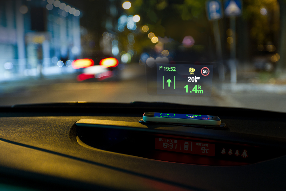
Used TomTom on Android, lately I use Sygic on iPhone which has a convenient head-up display function as well.
The head-up display looks really cool. How do you keep it from falling?
I had Maps on while on the bus. As the bus moved, it indicated that I was in the middle of an open field. How could that happen? Is it problem with the app or the phone? Do garmin car gps have this problem?
As for power, if I put the iphone to the usb port of 12v port of the car, will the phone run out of power? In other words, will power usage faster or slower than charging when the iphone 6s+ is used as a car gps?
Last edited:
You can use a non slip dashboard mat.The head-up display looks really cool. How do you keep it from falling?
I had Maps on while on the bus. As the bus moved, it indicated that I was in the middle of an open field. How could that happen? Is it problem with the app or the phone? Do garmin car gps have this problem?
As for power, if I put the iphone to the usb port of 12v port of the car, will the phone run out of power? In other words, will power usage faster or slower than charging when the iphone 6s+ is used as a car gps?

With a quality charger (carkit) you won't have a problem.

Last edited:
There are no data costs as most of the navigation software (TomTom, Sygic etc.) work off-line (i.e. the maps are downloaded to your phone). The phone will only communicate with the satellites, but it does not imply any costs.So, I only need to take the cost of data into consideration. Can I get some kind of free satellite usage without using the 4G data plan on my phone? Perhaps through some kind of satellite cable?
There are no data costs as most of the navigation software (TomTom, Sygic etc.) work off-line (i.e. the maps are downloaded to your phone). The phone will only communicate with the satellites, but it does not imply any costs.
That is temping. So, I just need to buy the app and the charger? How does the phone communicate with the satellites if it is not connected via 4G cellular data?
Your iPhone includes a GPS chip just like the one found in stand-alone GPS devices.That is temping. So, I just need to buy the app and the charger? How does the phone communicate with the satellites if it is not connected via 4G cellular data?
Yes, your costs will consist of the price of the app and a carkit (phone holder, charger and cable).
I had Maps on while on the bus. As the bus moved, it indicated that I was in the middle of an open field.
Maps was working as designed. https://www.apple.com/ca/letter-from-tim-cook-on-maps/
As for power, if I put the iphone to the usb port of 12v port of the car, will the phone run out of power? In other words, will power usage faster or slower than charging when the iphone 6s+ is used as a car gps?
If you are considering using the Plus you need give it as much power as possible. I had a good quality 2.1 amp supply in the car and my 6 Plus battery would be decreasing ever so slightly when the TomTom app was in use, which was annoying over a 6 hour journey.
But my current SE charges to 100% quickly using the same power, while using the sat nav.
So if your car can't supply enough power for a 6 Plus you will have to buy the best car charger you can find. But that shouldn't be a problem.
As above, you don't need to worry about data unless the app requires you to have to re-sign in or something like that. Most navigation apps that allow you to download the map, ie not waze or maps, are designed so that they don't use an internet connection, except perhaps for configuring or managing them.
Last edited:
That's pretty cool-- just earned them a trial run on my phone...Same here, have been using navigation apps on mobile phones for years.
Used TomTom on Android, lately I use Sygic on iPhone which has a convenient head-up display function as well.
Thanks for the tip!
You are most welcome, AK!That's pretty cool-- just earned them a trial run on my phone...
Thanks for the tip!
")
While I have never owned a standalone GPS unit, I'd tried a bunch of iOS GPS navigation apps and I've stuck with freeware Waze (I started using it before it was acquired by Google).
The main reason for this is crowd sourced real-time road conditions, and we're not just talking traffic or accidents. Stuff like road construction, objects on road (including roadkill), vehicles parked on shoulder, police, etc. While the user provided reports might be scant in less populated areas, it works really, really well in large American metropolitan areas like the SF Bay Area.
I even use Waze on my normal commute -- not because I need instructions on where to go -- but primarily for the real-time road conditions.
Plus, Waze has developed some canny real-time turn-by-turn navigation based on actual traffic conditions. Sometimes it will tell you to get off a congested freeway and take surface streets to get to your destination. For sure, when you are using Waze on your smartphone, you are transmitting data back to the Waze servers.
The turn-by-turn navigation isn't perfect, but it's pretty darned good (it is probably benefitting from Google Maps since its acquisition). I wish it had better lane assist features and a heads-up display mode, but it's still my go-to GPS navi app.
This is one of the few Google services I use. The fact that Google loves collecting users' data works extremely well in this case. I created my Waze account long before Google acquired the service, and I am fortunate that Google has chosen to keep this as a separate product and not require me to use a Google account to use it.
I was chatting with garmin tech support the other day. He mentioned that for the new DriveSmart 61 LMT-S to update traffic information in real-time, I need to use smartphone's data or a HD Digital Traffic Satellite cable. How the Sygic provides up-to-date traffic information in real-time? Also through the iPhone's internal GPS?
Anybody used this app in Ontario Canada? Does it work well? I wonder how much storage is required.
Anybody used this app in Ontario Canada? Does it work well? I wonder how much storage is required.
hajime, I'm sensing some confusion about GPS that's causing you trouble.
In terms of your phone, or any other GPS device, the GPS system itself (the satellites) doesn't "communicate" with your phone. It's entirely one-way -- down from space, not up. Your GPS device receives signals from the satellites (basically, the satellites broadcast "here's which satellite I am and here's the time on my atomic clock," and the rest is up to the GPS receiver). Your GPS unit is passive with regard to the US GPS system (or Glosnass, or the new European one).
Then there are the apps and links that, having information about where your unit and/or phone is located, can respond to that information by sending you more information about traffic, etc. This are entirely separate procedures. They have nothing to do with the GPS system beyond that fact that before they can do anything useful, they have to know what positioning data your GPS unit or phone has gotten.
I think you've gotten those two data system mixed up with each other. Specifically, when you write "Through the iPhone's internal GPS?" you're mixing up GPS location data (passive) with traffic information (ordinary cellular data traffic having nothing to do with the GPS system).
hajime, I'm sensing some confusion about GPS that's causing you trouble.
In terms of your phone, or any other GPS device, the GPS system itself (the satellites) doesn't "communicate" with your phone. It's entirely one-way -- down from space, not up. Your GPS device receives signals from the satellites (basically, the satellites broadcast "here's which satellite I am and here's the time on my atomic clock," and the rest is up to the GPS receiver). Your GPS unit is passive with regard to the US GPS system (or Glosnass, or the new European one).
Then there are the apps and links that, having information about where your unit and/or phone is located, can respond to that information by sending you more information about traffic, etc. This are entirely separate procedures. They have nothing to do with the GPS system beyond that fact that before they can do anything useful, they have to know what positioning data your GPS unit or phone has gotten.
I think you've gotten those two data system mixed up with each other. Specifically, when you write "Through the iPhone's internal GPS?" you're mixing up GPS location data (passive) with traffic information (ordinary cellular data traffic having nothing to do with the GPS system).
Thanks. how do I get up-to-date traffic and road blockage information in real-time? I think Garmin GPS can suggest the best route to reach the destination in case of heavy traffic or sudden road closure.
Garmin says that it uses the "HERE" system.
https://support.garmin.com/faqSearch/en-US/faq/content/i34WV8maJa11t7iwvYnz18
https://here.com/en
Your device (whatever it is) is finding ways to receive the HERE data, which it can then interpret for you because your device knows its position thanks to the GPS satellites. However, as I said, this traffic data reception has nothing to do with the GPS system.
The HERE site appears to have maps of areas where it's active. You could check your location.
I have no idea, but I'm sure somebody out there knows. I'm just trying to help you with the basic concepts.
Thanks
[doublepost=1495412368][/doublepost]
There are no data costs as most of the navigation software (TomTom, Sygic etc.) work off-line (i.e. the maps are downloaded to your phone). The phone will only communicate with the satellites, but it does not imply any costs.
Do the apps download my city or state/province? Do we have the option on which city/state/province to download? About how much storage will the maps take?
Any Canadian user?
I installed the free app Sygic: GPS Navigation, Maps, Traffic, Gas prices.
Upon launching, it found Canada and loaded the maps.
Then, in the app store, there is a
Sygic North America: GPS Navigation, Offline Maps at $22.99
and
Sygic Canada: GPS Navigation free
Know the differences between these? When I launched app store from my Mac, there is also a list of top in-app purchases;
- Premium North America
- Premium + Traffic North America
- Premium World, etc.
Which one(s) should I get to use the phone in Canada?
Geez. Just get Nokia Here. It's completely free and you can download maps of the whole planet onto your phone so you don't need a data connection ever. It may not be free forever because Mercedes just bought them.
Mercedes + Audi + BMW !
I tried to create a route to a big local shopping mall. I searched for the name of the mall but it replied "No items meet the search criteria". How come? The interface seems to be a bit different now compared with the demo on youtube. What symbol do I use to separate the city name and the destination (mall name or street name and number).
[doublepost=1495457820][/doublepost]Does the app accept voice command?
[doublepost=1495457820][/doublepost]Does the app accept voice command?
I'd say any stand alone sat nav device is now a waste of money. Smarthphone GPS is just as good (or better), but every smartphone has better software, faster chips and more up to date info. There's a reason why so few Sat Navs are sold / seen these days.
For a 'sat nav' app, I also recommend Waze. It's free and always has 'up to the minute' info about traffic conditions. This is because it shares traffic condition data with other Waze users. It's just much better than all the other apps I've tried.
I used to have a TomTom. It was brilliant about 10 years ago. I was so impressed, I eventually upgraded to a TomTom Go 520. This had 'IQ routes'. Which essentially meant that it gave different time estimates for routes depending on the time of day. This was pretty good, but didn't distinguish between weekdays and weekends. Driving in central London at 8am on a week day morning is quite a different experience from driving there at 8am on a Sunday morning. After a while, I switched to the TomTom app. This was also great for a while, but v expensive for the initial outlay. I think I paid £54.99 for it. It provided updates for years, but I think they are now going to charge for them.
A year or so ago I discovered Waze. It's been a revelation. It reacts to traffic conditions during the drive. It's ETAs are accurate, and update as you go. It's just been brilliant. It does use data while you drive, but the amount seems to be negligible. Most data plans provide far more than an average person needs, these days.
Register on MacRumors! This sidebar will go away, and you'll see fewer ads.