Another one has arrived. For Europe, £59.99 ($99.99) and 1.9GB download.
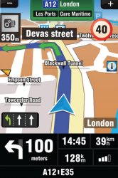
Seems to include Postcode Search and Safety Cameras. All maps included
The package includes the latest maps from Tele Atlas, the leading map provider. There are no monthly fees or hidden charges.
Seems to include Postcode Search and Safety Cameras. All maps included
The package includes the latest maps from Tele Atlas, the leading map provider. There are no monthly fees or hidden charges.
")