Become a MacRumors Supporter for $50/year with no ads, ability to filter front page stories, and private forums.

MacRumors

macrumors bot
Original poster
Apr 12, 2001
66,314
35,355


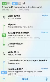
Several users are reporting seeing transit directions going live for Sydney, Australia in Apple Maps today, adding another major city for the the feature launched as part of iOS 9. Not all users are seeing transit routes for Sydney yet, but support is clearly rolling out at the moment for light rail, commuter rail, buses, and ferry service.

sydney_apple_maps_transit.jpg

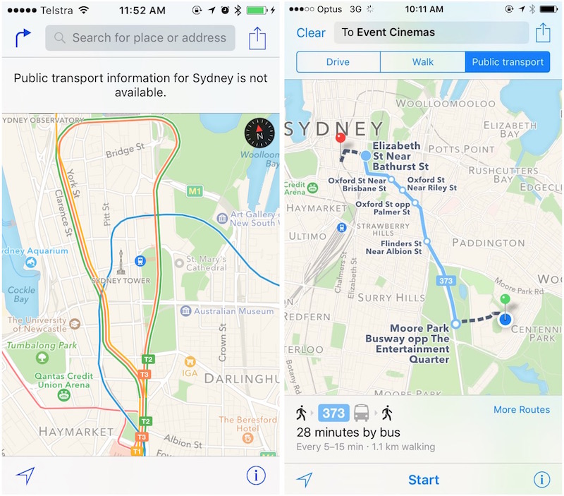
Apple added both Boston and Sydney to its list of supported cities for transit directions early this month, but quickly updated the listing to note coverage would be going live later in the month. Transit information for Boston went live last week alongside support for a number of Amtrak routes in the northeastern United States and nearby areas.

(Thanks, DrHampton!)

Article Link: Transit Directions for Sydney, Australia Going Live in Apple Maps
 
  • Like
Reactions: appledefenceforce
People are reporting very inconsistent results with the data.

Transferring to the same train:
dannolan_2015-Oct-26.png


Not so direct:
rpy_2015-Oct-26.png
 

Attachments

  • powellelogram_2015-Oct-26.jpg
    powellelogram_2015-Oct-26.jpg
    107.7 KB · Views: 7,360
  • Like
Reactions: Shirasaki
Whoa! LONG waiting!
Let me compare the result with TripView. And can I expect Siri to predict public transit result in proactive notifications?
And yeah! First city is Sydney.
 
(I am one of these people who are looking forward to delete all apps that have the same/simular functionallity than Apple apps.)

I have this notion that gMaps will be on my phone for another 3 years. aMaps is still a big mess.
 
Yay!

But holy crap, Wynyard to Gosford via ferry and bus? There are trains directly between the two.

OK what the? Train to Campbelltown then bus to the Gong? Again, there's a train right from Sydney to the Gong. Probably won't even need to change.

I reckon someone's done goofed.
 
image.png
Sort of kind of working in Newcastle by default as well. At least for buses so far anyway.
 
Gold Coast please - public transport is abysmyl for such a huge tourist hotspot, but with the addition of light rail and the upcoming Commonwealth Games it would be welcomed.
 
I'm really surprised the Newcastle and Central Coast line hasn't been included? They want me to take a bus down the M1 instead of the train. Who knows, Newcastle trains may come soon?

IMG_2753.png
 
Yay!

But holy crap, Wynyard to Gosford via ferry and bus? There are trains directly between the two.

OK what the? Train to Campbelltown then bus to the Gong? Again, there's a train right from Sydney to the Gong. Probably won't even need to change.

I reckon someone's done goofed.

You have to omit certain modes of transport to achieve desired results.
And still no avoid tolls option for driving.
 
Meanwhile Google Maps has realtime public transport information for the entire country here (the Netherlands). All modes included: train, metro (subway), tram, bus, ferries.

With Apple adding only a handful of cities per month and not even all modes it's going to take them a long, long time to catch up.
 
Are they having someone on the ground checking it out before release? Otherwise it's like operating a drone remotely - it can be messy...
 
And still no avoid tolls option for driving.

I don't think I've ever seen a toll that's worth avoiding before... avoiding a toll ends up consuming more time and gas, both of which have a monetary value, and that value has always been higher than the toll is worth.
 
Will be comparing the info between the Apple map and google map, Tripview and transport info. I doubt it will be accurate though....
 
Can somebody explain to me what Apple stands to gain from releasing the same product as everybody else, only several years later, and pushed out so slowly that people can only scoff at the incompleteness?
 
Can somebody explain to me what Apple stands to gain from releasing the same product as everybody else, only several years later, and pushed out so slowly that people can only scoff at the incompleteness?

78% of Google's users?
 
  • Like
Reactions: ErikGrim
Jeez. If they keep adding new cities in that slo-mo fashion they will have caught up with Google Maps in about 20 years!
 
I don't think I've ever seen a toll that's worth avoiding before... avoiding a toll ends up consuming more time and gas, both of which have a monetary value, and that value has always been higher than the toll is worth.
Absolute rubbish, where I live a 55 minute trip on toll roads costs $11, I can do the same trip in 60 minutes for nothing. So the return trip is $22 and all I save is 10 minutes, no thanks.

In peak hour maybe, but that's it.
 
  • Like
Reactions: Yumbo
Absolute rubbish, where I live a 55 minute trip on toll roads costs $11, I can do the same trip in 60 minutes for nothing. So the return trip is $22 and all I save is 10 minutes, no thanks.

In peak hour maybe, but that's it.
I use Apple map to plan a trip from Redfern station to Bondi junction station.

Apple map recommends me taking bus, while I can just take T4 train to that station. Interesting.
 
Jeez. If they keep adding new cities in that slo-mo fashion they will have caught up with Google Maps in about 20 years!
Buy that time you'll be able to swallow a Google maps pill and you'll get all the information fed into your brain and Apple will still be trying to get maps for Brisbane.
 
I use Apple map to plan a trip from Redfern station to Bondi junction station.

Apple map recommends me taking bus, while I can just take T4 train to that station. Interesting.
I don't use Apple maps for anything, I've got a HTC M8, it's never led me up the garden path. Hopefully in the next couple of days I'll have the Samsung Galaxy Note5, again, no Apple maps.
I could use my iPad Mini 4 but I don't trust Apple maps in Australia at all.
 
Register on MacRumors! This sidebar will go away, and you'll see fewer ads.