Got a tip for us?
Let us know
Become a MacRumors Supporter for $50/year with no ads, ability to filter front page stories, and private forums.
What is the practicality of flyover mapping?
- Thread starter b24pgg
- Start date
- Sort by reaction score
You are using an out of date browser. It may not display this or other websites correctly.
You should upgrade or use an alternative browser.
You should upgrade or use an alternative browser.
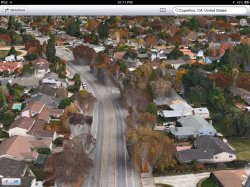
Unless you travel by helicopter, is there any practical use for flyover maps or is it just a novelty thing?
Havent really seen much practicality in it.... Bad trade off for street view.
I think it is very useful, it's great to see the actual buildings like your above the street so you can easily and quickly tell where you are/where you need to go and then you can quickly see a Birdseye veiw when needed.
Attachments
Last edited:
I think it is very useful, it's great to see the actual buildings like your above the street so you can easily and quickly tell where you are/where you need to go and then you can quickly see a Birdseye veiw when needed.
I guess this will help Spiderman.
Google's Street View was really, really useful. I'm not sure how Flyover is supposed to be a functional replacement. I need a view of the building I'm looking for from a street level perspective, not--as a previous poster quipped with pure genius--Spiderman's perspective.
Google's Street View was really, really useful. I'm not sure how Flyover is supposed to be a functional replacement. I need a view of the building I'm looking for from a street level perspective, not--as a previous poster quipped with pure genius--Spiderman's perspective.
This was beyond useful.

Another gimmick in a long line of Apple gimmicks .Unless you travel by helicopter, is there any practical use for flyover maps or is it just a novelty thing?
I guess this will help Spiderman.
Haha! Too true. I sincerely believe that 3D is probably the biggest gimmick after Siri. Things at Apple are just getting less practical and more novelty-based these days.
IDK....personally, I think I'd have more use out of Flyover than Street View.
Street View, while I love it and it's a ton of fun to play with, isn't all that practical for me in a "now driving" situation....because once I recognize where I am based on what's displayed on the screen, I'll have already passed where I want to be.
Flyover seems like it'll be better for a "this is where I need to go soon" sort of future planning approach, if that makes sense.
That being said, however, if Maps looks at all like it does in beta right now, I'll likely never use the app and pray Google releases their own app.
IDK....personally, I think I'd have more use out of Flyover than Street View.
Street View, while I love it and it's a ton of fun to play with, isn't all that practical for me in a "now driving" situation....because once I recognize where I am based on what's displayed on the screen, I'll have already passed where I want to be.
Flyover seems like it'll be better for a "this is where I need to go soon" sort of future planning approach, if that makes sense.
That being said, however, if Maps looks at all like it does in beta right now, I'll likely never use the app and pray Google releases their own app.
uhhh, if you say so... Now unless your approaching from a helicopter to your destination, than YES! it is GREAT! or like another has mentioned already dropping in from a rooftop like spiderman.
Please don't justify Apple's horrible marketing gimmick. Flyover is NOWHERE nearly as useful, nor practical, as streetview.
Streetview has saved me tons of times... In my line of work, I typically ask people for a specific address of something but they can never provide it for me. So its then that I bust out my Galaxy note, load up the closest intersection they can remember or provide me with, then use streetview to navigate to the house/business/etc...
I doubt those same people would know what the roof and treetop would look like from above

I agree. I haven't used flyover yet as I'm not a developer, but I've used street view a ton of times and I'm not sure how flyover can be a replacement. It does seem like a gimmick.
However, someone on here called Siri a gimmick, and I disagree. You may not use Siri, and have no use for Siri, but others do, so it's not a gimmick. It's one of the best pieces of voice recognition out there. I don't personally use it much myself, but I don't consider it a gimmick.
However, someone on here called Siri a gimmick, and I disagree. You may not use Siri, and have no use for Siri, but others do, so it's not a gimmick. It's one of the best pieces of voice recognition out there. I don't personally use it much myself, but I don't consider it a gimmick.
I think it is very useful, it's great to see the actual buildings like your above the street so you can easily and quickly tell where you are/where you need to go and then you can quickly see a Birdseye veiw when needed.
Looking at the picture makes me feel like Apple has indeed taken a step back. Seriously, how can it compare to street view?
Then we might say that this is just a beta and things will improve. I doubt much will change to Apple's maps other than usability function.
Mad Mac Maniac
macrumors 601
I don't think anyone would argue that flyover is as useful or practical (at least in it's current implementation) as street view (although street view on my iPhone is so slow that it's more annoying than anything else).
But I do think it can certainly be useful in certain scenarios. And I wouldn't classify it as purely gimmick. All you Google maps defenders out there, don't forget google has pretty much the exact same implementation of this in google earth, and just held a conference a week ago to beat their chest and show off their enhanced 3D effects ahead of Apples 3D effects.
I also think that flyover will be able to evolve to a "flythrough" if you will, which will be more of a direct replacement to google maps. This will basically be very detailed imagery which allows you to follow along the street on a rail. Kind of a combination of google street view, flyover, and Apple's turn-by-turn navigation. Where this will beat streat view, is because it could have the ability to jump off the rail and go fly around parking lots, looking for specific stores, etc.
I don't understand how people are comparing this to streetview at all.
It's like comparing a hammer and a screwdriver. Yes, I can see how they're similar in that they have a rubber handle, but who would ever try to use one for the use of the other? One is clearly not meant to replace the other.
Serious question: Have most of you never used this view on your GPS?

Holy crap! I'm flying above my car!
Because I thought that was pretty common. Many of you seem astounded by the concept.
It's like comparing a hammer and a screwdriver. Yes, I can see how they're similar in that they have a rubber handle, but who would ever try to use one for the use of the other? One is clearly not meant to replace the other.
Serious question: Have most of you never used this view on your GPS?
Holy crap! I'm flying above my car!
Because I thought that was pretty common. Many of you seem astounded by the concept.
Street View's data is usually so old and the coverage is so spotty that its generally useless for me. Most people I know didn't even know it was on their iPhones.
The biggest benefit of flyover is the potential to cover far more land and be updated more often since the data is acquired by flying planes over the area rather than the much slower method of driving cars around.
And Street View obviously doesn't give you nearly as wide or depth of viewing as flyover does which makes it useless when driving. It's only useful when walking or in a static location. Flyover can be used while driving and its dynamically rendered. They are for two different things.
----------
Exactly! Just saw your post.
Street View is not useful when driving. Flyover is great when driving. There is a major difference between them.
The biggest benefit of flyover is the potential to cover far more land and be updated more often since the data is acquired by flying planes over the area rather than the much slower method of driving cars around.
And Street View obviously doesn't give you nearly as wide or depth of viewing as flyover does which makes it useless when driving. It's only useful when walking or in a static location. Flyover can be used while driving and its dynamically rendered. They are for two different things.
----------
I don't understand how people are comparing this to streetview at all.
It's like comparing a hammer and a screwdriver. Yes, I can see how they're similar in that they have a rubber handle, but who would ever try to use one for the use of the other? One is clearly not meant to replace the other.
Serious question: Have most of you never used this view on your GPS?
Image
Holy crap! I'm flying above my car!
Because I thought that was pretty common. Many of you seem astounded by the concept.
Exactly! Just saw your post.
Street View is not useful when driving. Flyover is great when driving. There is a major difference between them.
And Street View obviously doesn't give you nearly as wide or depth of viewing as flyover does which makes it useless when driving. It's only useful when walking or in a static location. Flyover can be used while driving and its dynamically rendered. They are for two different things.
This is what I was thinking. Street View is nice but its never been of any use to me and navigating in Street View has always been slow.
What I have seen in Flyover makes it feel a lot more useful for getting a birds eye view of where you area lot easier than pictures from a few meters above ground especially when the view is blocked by road signs, vehicles and buildings and actually looking around an area is a lot more user friendly in Flyover.
Street View's data is usually so old and the coverage is so spotty that its generally useless for me.
Can you provide a link where Apple states they will be constantly updating their data?
Street View isn't spotty at all, and I don't live in a major US city. I live in a rural area in Canada that has street view coverage all over. Just because it's supposedly spotty for you, doesn't mean it actually is spotty.Street View's data is usually so old and the coverage is so spotty that its generally useless for me. Most people I know didn't even know it was on their iPhones.
The biggest benefit of flyover is the potential to cover far more land and be updated more often since the data is acquired by flying planes over the area rather than the much slower method of driving cars around.
And Street View obviously doesn't give you nearly as wide or depth of viewing as flyover does which makes it useless when driving. It's only useful when walking or in a static location. Flyover can be used while driving and its dynamically rendered. They are for two different things.
----------
Exactly! Just saw your post.
Street View is not useful when driving. Flyover is great when driving. There is a major difference between them.
You also know that Apple won't be flying planes around on a daily basis, right? The only thing they could do, is partner with major airlines to put cameras on the plane to get updated photos more often. Apple probably wouldn't be updating more often than Google does.
I think it is very useful, it's great to see the actual buildings like your above the street so you can easily and quickly tell where you are/where you need to go and then you can quickly see a Birdseye veiw when needed.
lol @ how trees are rendered.
Since you can zoom in, I think this is a pretty cool replacement of street view. Seems less frustrating to navigate.
The street view is good, because it's available for lots of places all around the world apart from flyover which has like 10 cities. (I know it's just beta, but still I don't think they can map the rest until october)
People keep saying that 3D maps is a fine replacement for street view.... yeah if you live in the 30 cities they probably have covered.
Its not even up for debate. Lets compare when Apple's 3D feature covers this (which is Street View's coverage):

Its not even up for debate. Lets compare when Apple's 3D feature covers this (which is Street View's coverage):
People keep saying that 3D maps is a fine replacement for street view.... yeah if you live in the 30 cities they probably have covered.
They might not have 3D mapping of everywhere yet but Google didn't have street view everywhere in an instant. It took them time to build up the coverage as it will Apple but we also do not know how much they already have from their purchase of C3 who had previously showcased other places like London, Venice and Kenya.
They might not have 3D mapping of everywhere yet but Google didn't have street view everywhere in an instant. It took them time to build up the coverage as it will Apple but we also do not know how much they already have from their purchase of C3 who had previously showcased other places like London, Venice and Kenya.
So what you're saying is, Apple expects its consumers to deal with losing a product thats matured for the past 6 years and covers the entire nation and give a new product a few years to develop? And you're ok with that?
People keep saying that 3D maps is a fine replacement for street view.... yeah if you live in the 30 cities they probably have covered.
Its not even up for debate. Lets compare when Apple's 3D feature covers this (which is Street View's coverage):
Image
No, 3D maps aren't a replacement for Street View. They are an additional feature to the Apple Maps app that not even Google is doing right now. Google held a hastily rushed press conference right before WWDC to announce their 3D maps which didn't look as good as what Apple showed off. And they gave no date on when it would ever be available either.
Street View is something entirely different and used for an entirely different purpose. Google will have to find some way to catch up to what Apple has in developer's hands right now with the 3D maps when their 3D maps are available in something other than a press conference.
----------
So what you're saying is, Apple expects its consumers to deal with losing a product thats matured for the past 6 years and covers the entire nation and give a new product a few years to develop? And you're ok with that?
Since when has Google had 3D maps? Apple has a satellite view too but satellite view isn't a 3D map. Neither is Street View. Google is the one playing catchup here when you're referring to Apple's 3D maps.
Register on MacRumors! This sidebar will go away, and you'll see fewer ads.