Become a MacRumors Supporter for $50/year with no ads, ability to filter front page stories, and private forums.

MacRumors

macrumors bot
Original poster
Apr 12, 2001
66,559
35,801


Apple today announced that its revamped Maps experience is now available in the Canadian cities of Toronto, Montréal, and Vancouver.

apple-maps-3d-canada.jpg

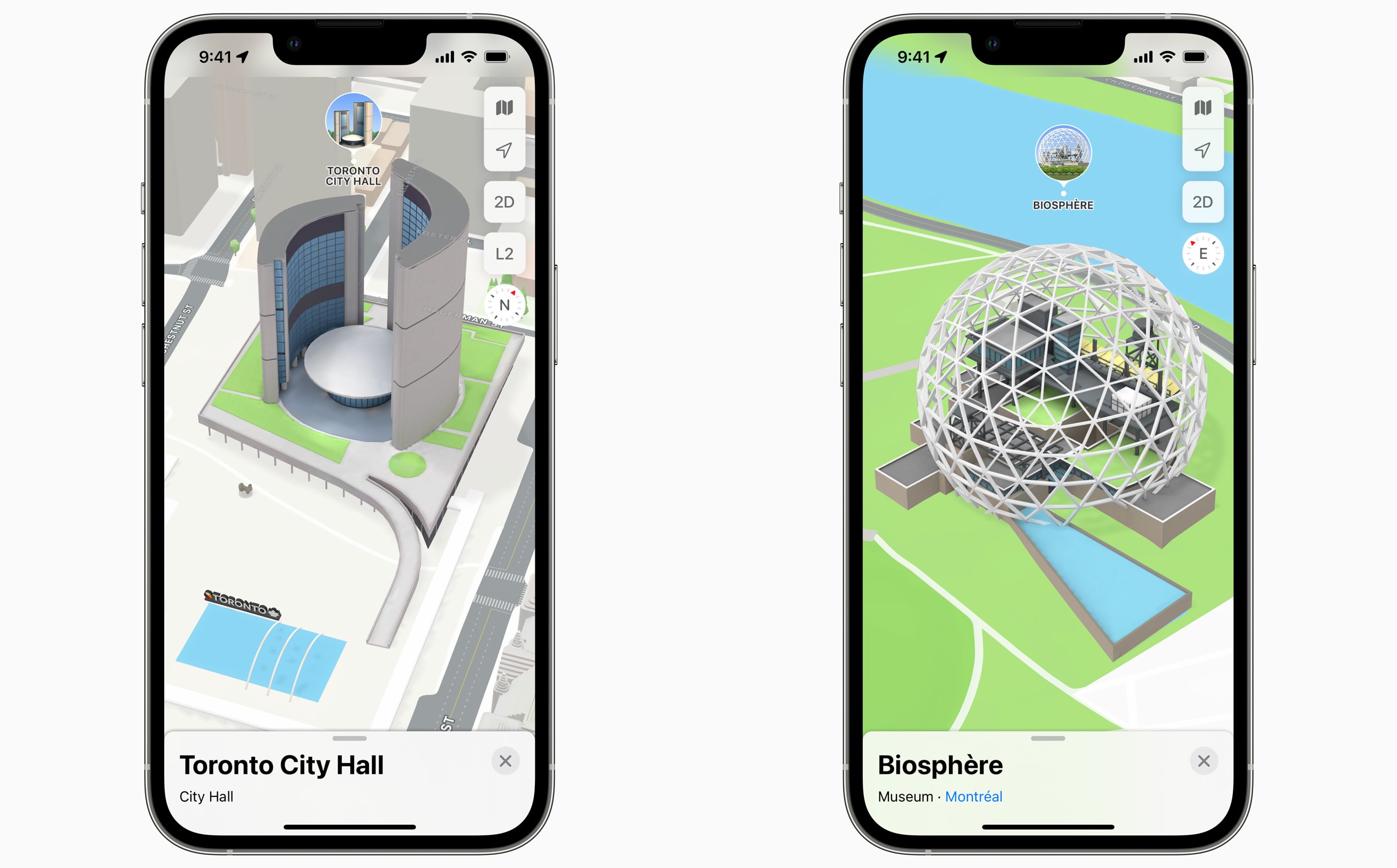
The update delivers more detailed maps, complete with custom-designed 3D landmarks, such as the Hockey Hall of Fame in Toronto, Notre-Dame Basilica in Montréal, and Robson Square in Vancouver. Navigation is also improved, with more detailed road markings and a 3D road-level view when approaching complex intersections.

The improved city experience is also available in London, Los Angeles, New York, Philadelphia, San Diego, San Francisco, and Washington, D.C.

"We're excited for Apple Maps users to explore the beauty and culture of Montreal, Toronto, and Vancouver in an incredibly detailed new way," said Apple's services chief Eddy Cue. "Built with privacy at its core, this update is the continuation of our commitment to building the best, most accurate map of the world — with a beautifully designed experience and attention to detail that only Apple can deliver."

Article Link: Apple Announces Revamped 3D Maps in Toronto, Montreal, and Vancouver
 
Last edited:
  • Like
Reactions: ipedro
The best, most accurate map of the world — with a beautifully designed experience and attention to detail that only Apple can deliver.
Google Maps -> Any City Worldwide -> Satellite -> 3D

Boom, you get the same basic thing but more detailed since the buildings are actually textured.

And Google has been doing this for over a decade. Maybe 15 years by now? I remember Sketch Up played a major role in acquiring all the building models.

I remember Microsoft Bing Maps were also touting 3D maps before Google Maps started doing it.

So... no, this isn't unique to Apple, at all. It's an arguably inferior copy of what others have been doing for a long, long time.

It could be argued that Apple's cartoony graphics are preferable to more realistic textures... IDK... I figure just running the real textures through some cartoon filters to achieve the same thing wouldn't be that hard.
 
Interesting (weird?) choice of landmarks for Montreal…

The Bell Centre?
Orange Julep?

What about bridges, historical buildings?

?‍♂️
There's a few more though. St-Joseph's Oratory, the Great Wheel, Olympic Stadium and the Biosphere, which was the US Pavillion of Expo '67.

Habitat '67 isn't part of the landmarks, weirdly, but it's actually well detailed. Couldn't say as much for the Jacques-Cartier Bridge.

Great surprise though, because I never thought we'd get this feature this year though. I was expecting it in or after Q4 2023 (not kidding).
 
  • Like
Reactions: DeepIn2U
Google Maps -> Any City Worldwide -> Satellite -> 3D

Boom, you get the same basic thing but more detailed since the buildings are actually textured.

And Google has been doing this for over a decade. Maybe 15 years by now? I remember Sketch Up played a major role in acquiring all the building models.

I remember Microsoft Bing Maps were also touting 3D maps before Google Maps started doing it.

So... no, this isn't unique to Apple, at all. It's an arguably inferior copy of what others have been doing for a long, long time.

It could be argued that Apple's cartoony graphics are preferable to more realistic textures... IDK... I figure just running the real textures through some cartoon filters to achieve the same thing wouldn't be that hard.
Apple Maps buildings are actually textured if you select the satellite version.
 

Attachments

  • 1.jpeg
    1.jpeg
    258.1 KB · Views: 911
I still try Apple Maps every once in a while but I find it SO confusing how the public transport options are presented (maybe I am too used to the Google Maps UI), doesn“t search for an actual STOP probably (instead it suggests me a „street“ with the same name itself. It also does not show me which exit to take (at least in my city). Also no bike routes, real time occupancy or offline maps!
 
Last edited:
  • Like
Reactions: Miha_v
Meanwhile, main street in my city looks like there's nothing there. Still crap after all these years (but the navigation UI is the best).
 
  • Like
Reactions: Miha_v
These images sure look great. However, if you're not living in one of the biggest cities in the world, experience with this app can be much different. Not just lacking in useful information, almost everytime (I accidentally) ran Apple maps instead of Google maps, it showed me the wrong target location(!), beyond frustrating. Google is still years ahead on this one...
 
  • Like
Reactions: DreadedFun and psxp
Me too, but it has nothing to do with Maps.

Still don't understand why they ousted Forstall either.
That’s right. Just mentioned it because Cue gave the interview. The Forstall ousting was surprising and a political one. If we can believe sources it was part because of Jonny Ive. This gave us better maps and iOS 7 - but let’s be honest: since then nothing really changed visibly, which should be a priority on Apple‘s list.
 
  • Like
Reactions: PsykX
It's a shame Maps had such a bad introduction as people still think it's that bad from ages ago. Whilst there is room for improvement, it does everything that I don't need to use another maps app. I also prefer the look of Maps as I feel it's cleaner and more aesthetically pleasing than Google Maps or others.
 
Google Maps -> Any City Worldwide -> Satellite -> 3D

Boom, you get the same basic thing but more detailed since the buildings are actually textured.

And Google has been doing this for over a decade. Maybe 15 years by now? I remember Sketch Up played a major role in acquiring all the building models.

I remember Microsoft Bing Maps were also touting 3D maps before Google Maps started doing it.

So... no, this isn't unique to Apple, at all. It's an arguably inferior copy of what others have been doing for a long, long time.

It could be argued that Apple's cartoony graphics are preferable to more realistic textures... IDK... I figure just running the real textures through some cartoon filters to achieve the same thing wouldn't be that hard.
And they do it all to steal your data.
 
  • Like
Reactions: ikir
It's a shame Maps had such a bad introduction as people still think it's that bad from ages ago. Whilst there is room for improvement, it does everything that I don't need to use another maps app. I also prefer the look of Maps as I feel it's cleaner and more aesthetically pleasing than Google Maps or others.
Every few months I try Apple Maps but every time I conclude that Google Maps has better directions (Toronto).

I guess with this update I’ll have to try it yet again.
 
  • Disagree
  • Like
Reactions: psxp and DeepIn2U
Register on MacRumors! This sidebar will go away, and you'll see fewer ads.