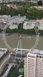
People use maps for many reasons. While a London Eye rotating at a far too rapid rate is meaningless for point-to-point route planning, for those like me, who also love maps as a form of armchair tourism, research resources, and the like... something of this sort can be a delight, similar to a software Easter egg. This kind of thing influences my choice of mapping resources - "capturing the hearts and minds" is a useful business strategy. Other, more practical features are critical, too, of course - I'd like to have both Street View and Flyover. At times, Google Earth's measurement function is an essential capability...
In my driving, (Eastern USA) it's been quite a long time since I've encountered a routing error, and now that I have an iPhone capable of it, I'm really enjoying Apple's implementation of turn-by-turn navigation. YMMV, of course.
As to POI data? Both Google and Apple leave a bit to be desired. I happen to have an interest in rivers and streams - I've found Apple to be better at this than Google. And (on a less serious note), displaying current road traffic conditions is all well and good, but when are we going to see real-time barge traffic on the Thames, aircraft take-off and landing at Heathrow, positions of trains in the Underground, etc.? Currently, I have to pay a subscription to accurately locate the container ships delivering my goods (free maps show week-old positions at the moment), when is Apple going to spare me that expense, huh?
It is kind of cool that Big Ben is displaying the correct time. However, iif one wanted to be truly accurate... It's currently February 26, 2:45 PM (14:45) on the U.S. East Coast, which means London should be in the dark. One wouldn't know that unless one zoomed out a substantial distance (day/night terminator is currently a bit west of Iceland). Between the green foliage in St. James Park and ambient lighting more accurate for summertime than winter... Damn, can't Apple get
anything right?
")