Become a MacRumors Supporter for $50/year with no ads, ability to filter front page stories, and private forums.
Yes they could, but that was not the point. "Apple’s privacy focus" is just a publicity stunt, that was the point.

They know everything about your Mac and they decide what you are allowed to install or not, but their "privacy focus" is great :)
You’re certainly free to believe whatever you like.
 
Yes, I'm free to believe I shouldn't have to use dosdude patcher to get the full Mojave installer, this is another good example of "Apple’s privacy focus".
 
What if people don’t have other Apple devices?
It seams people trust as much Google and Microsoft anyway.
GL with the investment.

Unless I really see a big jump in the Mac space don’t see much the relevance of Maps over other options.


Apple Maps Product Lead David Dorn and Design Lead Meg Frost recently did an interview with CNN to explain the Apple Maps features that were introduced with the iOS 15 update and to explain why iPhone users should choose Apple Maps over other mapping apps like Google and Waze.

philadelphia-3d-maps.jpg

According to Dorn, there are three major reasons why Apple Maps is the best choice.
  1. Apple is making serious investments into Maps to improve it.
  2. Privacy is central and Apple isn't tracking your location for data purposes when you use Apple Maps.
  3. Maps is part of the Apple ecosystem and integrates well with other Apple devices and services.
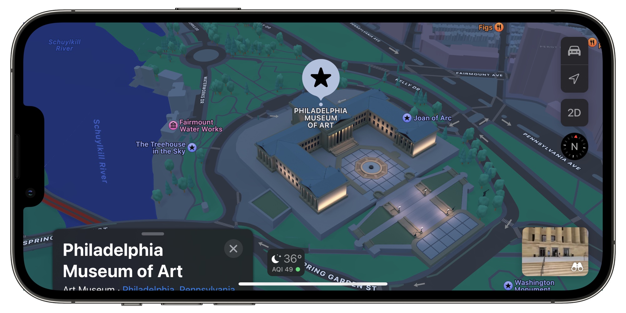
Apple's effort into improving the Maps app can be seen in iOS 15, an update that added new 3D city details in select areas like London, New York, Los Angeles, and the San Francisco Bay Area. There are also navigation updates that add more detail at complex interchanges. Frost said that Apple wanted to make maps "both safer and visually satisfying to navigate."

As for the 3D landmarks added in the update, each landmark is created by hand. "We pick the amount of detail we find appropriate and create a 3D mesh of the building landmark itself. And we apply it to the base map," Frost told CNN.

The full Apple Maps interview can be read over on CNN's website, and it provides more detail on features like Share ETA, CarPlay, real-time AR walking directions, and more.

Article Link: Apple Exec Explains Why You Should Use Apple Maps
The issue with Maps is its lack of useful trip planning features.
Adding “stops” (waypoints) between start and end locations is too basic and limited. Users should be able to add multiple, specific stops for any address, contact or business, both in an order specified by the user or recommended by Maps optimized for efficiency.

A “record a route” feature would be great for saving and sharing a very specific route to use that may never be offered by the Maps algorithm because it might not be time, traffic or distance efficient.

User should be able flag a specific section/road to avoid along a recommended route, even if the re-routed path adds time or distance.
 
I was feeling spontaneous yesterday and decided to try Apple Maps since I like the voice better than Google Maps.

It told me to go onto a certain street that leads towards a big port in my city and is illegal to drive into without proper credentials. Had a really awkward conversation at the security gate and had to get turned around.

Deleted the app after that. Never again. It's been over 9 years now and that street has apparently always been closed to the public, and yet it still got suggested to me.
 
  • Like
Reactions: psac
CNN?? I guess they’re not very confident in their own product if they’re doing the interview at a failing corporate media org that’s down something like 80% in viewership this year.

It’s understandable. Apple should be embarrassed that after 10+ years, it’s still behind google maps except for UX. When Apple announced it, I was confident Apple would overtake it in 5 years because SJ was behind the move. And while I use it, I still don’t fully trust it. Taking me to the wrong block in NYC for an address that hasn’t changed in decades is inexcusable in 2021. And outside the US, it’s still useless in many countries.
 
Marketing. If Apple put a dedicated advertising campaign behind Maps, they could grow some market share. But I doubt they'd do that because Maps doesn't make them any money.

Not sure. Apple do not run dedicated advertising campaigns for their other free bundled apps and almost everybody on iOS/iPadOS uses them, since they came preinstalled. If Apple really care about Maps, they should improve it globally, getting the priorities right. For example, a solid POI database, IMO, is way more useful = important compared to hand-designed landmarks. Sure, this is nice too, but it is like custom painting one window of the house with unfinished walls and roof.
 
Because it's not an inferior product. Not everyone wants to use an ad-infested ****box that reports all their movements directly back to Google. Maybe you're willing to pay for it in personal data, but not everyone wants to make that same choice, yeah?

FWIW, I use AM 95% of the time, as I like its UI better. However, their POI database is inadequate where I live. When Apple had a chance they should have bought Waze, which could have made AM way better, as Waze was very well used by then, so it would feed way more traffic data/info into the app.
 
  • Like
Reactions: Karma*Police
Having read the CNN article, hopefully it can create some sort of attention amongst its readers to give AM a first or another try. However, while praising AM, the CNN conveniently forget to mention that most of the amazing features they talk about are only available in the US and a handful of other countries, while Waze and Google cover pretty much the whole world.

The last article’s paragraph sounds somewhat uncertain:

“And if Apple Maps is doing its job right, Dorn says it can remove a “cognitive load” off of the user and let you focus on the road. Precise details and accurate environments [where available!] can certainly help get you on the right path for that.”

If I were responsible for AM, I would roll out noticeable updates to it much more frequently, instead of waiting for everything to be picture perfect and crafting each “climate-appropriate tree” by hand. It is a very nice touch to be able to see the London Wheel spin, but probably should be done when all the core services (POI come to mind again) are solid, worldwide.
 
Probably the ability to just have a driving mode where you don't need to set a destination. It gives you all the info like speed of the road, traffic, accident reports, etc. as you drive along without having to bother to tell it where you are headed. I like doing that for traveling places I go all the time. I don't need the navigation telling me when to turn if it's just my daily commute. I just need to see if there's an accident up ahead, or some crazy traffic and I might want to take the back way. It's something I would love Apple Maps to add as its a feature I use all the time on other navigation apps.

An idea list:
  • Some sort of dynamic voice directions: kind of like a "focus" mode:
    • No voice directions when near home/work or other user defined zone. The places you know well.
    • Voice directions only when the route is significantly different from normal due to accidents or other causes (home-work commute).
    • Voice directions only when traffic is heavy and when near destination.
  • Parking reservation service near destination.
  • Extended traffic data (full TomTom traffic support, including flow control).
    Maybe an extra choice when to automatically reroute: avoid heavy traffic instead of only avoiding traffic congestion/jams.
  • Alert with sound (overriding radio or music app) when ambulances or other emergency vehicles in pursuit are approaching. Exists in some countries in a separate app. I've heard some very expensive car models have this too as a part of a road assistance package.
  • Options for avoiding zones or even entire city areas. Usually you can only avoid specific roads. At the moment I try to do this using waypoints, but this limits (basically disables) the automatic alternatives in case of traffic jams / accidents around that point.

    Examples:
    • When driving through France and you need to pass the Paris area, sometimes its better to go around it big time, just to have a relaxed drive even when it takes a bit more time.
    • In some other "old" cities the motorway passes groundlevel through the city centre including loads of crossings with traffic lights. Something I usually like to avoid.
  • Live fuel / charging suggestions based on data from the car systems and price data from the internet.
    At the moment I have to calculate this in advance using sites like fuelflash.eu and furkot.com
Feel free to add more...
 
Look at how much progress we made!

Good for you, but you did start at a lower level.
 
The wide range of opinions seen here can be explained by the location of the reviewer.

In Toronto, Apple Maps has been incredible and possibly even superior to Google Maps from early on. Flyover and LookAround took it beyond Google Maps. They’re so much better than Google’s satellite view and clumsy stitching and janky travel in StreetView.

But a Map is nothing without accuracy and if you’re in a city with poor map data, then of course it’s a non starter. For those lucky enough to live in cities with regular map data updates, then Apple Maps can seriously be seen as better than Google Maps.

Are you sure? Because Apple Maps has been taking me to nowhere land when I visited few provincial parks around Toronto Area. Apple Maps can’t figure out where the gate is…. I have to resort to Google Maps.
 
Are you sure? Because Apple Maps has been taking me to nowhere land when I visited few provincial parks around Toronto Area. Apple Maps can’t figure out where the gate is…. I have to resort to Google Maps.
To be fair, I've had the same issue with Google Maps at provincial parks in Alberta, and at the ferry terminal outside of Vancouver.

As a result, I now have a deal with my wife when we drive that I'm ignoring computer map directions inside of 5 km to a destination and will rely on local signage instead (deal made as a result of aforementioned ferry terminal entrance fiasco outside of Vancouver, where Google got us all turned around despite the road signs being entirely correct.)

The point is that neither map is perfect, and ultimately it comes down to your personal preferences. I used Google Maps forever due to Apple Maps trying to murder me once by insisting I turn right into a road that no longer exited that was now an LRT track (that had a train crossing that would have killed me). Now that Apple has mapped my city, and provided traffic reporting features in CarPlay, it suits *my* preferences for my local driving purposes. If your mileage varies, fair enough.

That’s fair. Apple Maps is also one step behind than Google Maps in my opinion. It take Apple Maps few months after Google when new road was constructed behind my local Costco.

But most time I am using Waze anyway, because I got speed ticket last year. LOL. Waze saved me countless time this year.
 
Driving from Tennessee to Michigan yesterday (Dec. 23), I used Apple Maps to find a "UPS Store" in the south side of Louisville. We dutifully followed the directions to "The UPS Store" to... the door of an administrative building of an area hospital, which had been there for quite some time.

As fate would have it, a brown UPS truck rolled up to the building at the same time. I asked the driver if there was a UPS Store here or nearby. "No, not at all... there's a UPS Store about 10 minutes south of here but not in this building."

15 minutes of drive-time lost.

I reported the issue to Apple Maps. After seeing this article this morning, I checked to see if it was still showing up on Apple Maps. It's not. So, I'll give Apple props for nixing that bad info so quickly.

(I did find a UPS Store later south of Cincinnati. They wanted $68 to ship a package to arrive *next Monday* in central Illinois. I ended up at a FedEx store instead: It'll arrive Sunday for $14.)

When Apple Maps allows me to anonymously share my telemetry data with other Apple Maps users (to inform their devices of conditions and alternate routes), I'll drop Waze.
 
An idea list:
  • Some sort of dynamic voice directions: kind of like a "focus" mode:
    • No voice directions when near home/work or other user defined zone. The places you know well.
    • Voice directions only when the route is significantly different from normal due to accidents or other causes (home-work commute).
    • Voice directions only when traffic is heavy and when near destination.
  • Parking reservation service near destination.
  • Extended traffic data (full TomTom traffic support, including flow control).
    Maybe an extra choice when to automatically reroute: avoid heavy traffic instead of only avoiding traffic congestion/jams.
  • Alert with sound (overriding radio or music app) when ambulances or other emergency vehicles in pursuit are approaching. Exists in some countries in a separate app. I've heard some very expensive car models have this too as a part of a road assistance package.
  • Options for avoiding zones or even entire city areas. Usually you can only avoid specific roads. At the moment I try to do this using waypoints, but this limits (basically disables) the automatic alternatives in case of traffic jams / accidents around that point.

    Examples:
    • When driving through France and you need to pass the Paris area, sometimes its better to go around it big time, just to have a relaxed drive even when it takes a bit more time.
    • In some other "old" cities the motorway passes groundlevel through the city centre including loads of crossings with traffic lights. Something I usually like to avoid.
  • Live fuel / charging suggestions based on data from the car systems and price data from the internet.
    At the moment I have to calculate this in advance using sites like fuelflash.eu and furkot.com
Feel free to add more...

#7: "Mute My Neighborhood" Setting.

I'd like for Apple Maps to tell me to get to the nearest major road instead of turn by turn.

Example: "Head out to I-840 east."

...instead of this, when I back out of my driveway...

"Head West on Billings*, then right on Armory." I turn right...
"Turn left on Shelby, then right onto Pendleman. At the stop sign, turn Left onto Blockmon Rd." I make all those turns.
"In a quarter mile, turn Right onto Veterans Highway." I turn right.
"Stay right to turn onto 840 east."

In other words, I know how to get out of my neighborhood to major roads, and it's annoying to hear all the TBT directions every. single. time.

Since Maps knows my home address, I should be able to say "Mute My Neighborhood" with possible options of
* Distance to begin turn-by-turn.
* Approximate time to begin turn-by-turn.
* Select intersection to begin turn-by-turn. // If I "go out the back way," then TBT could fall over to the distance or time setting, above.


#8: "Attention Please" tone.

When I'm a mile or so out from a major turn (especially on the highway), I'd like Maps to play a unique 'tone' or chime to advise me that a lane change, intesection, exit, etc. is coming up. Just a quick 'boop' or 'pwerp' or whatever single-ping noise to get my attention.


I've been using Waze, so I'll give Apple Maps a fresh try on next week's road trip.
 
  • Like
Reactions: Azzin
I live in the SF Bay Area, so it works great around here and is my only maps app.

Not sure how I’d feel if I lived elsewhere…
 
I use Apple Maps a lot but sometimes need to go to Google Maps for a better street view or satellite map. Apple's version of Street View is way better than Google, but it's going to take a while for it to be everywhere.
 
They are working on features that people don't care as much about. What most people use the maps app for are traffic data, accident reports, police speed traps, and such... all without having to select a location for navigation. This is what they should focus on. Instead they are giving us 3D. Yawn. Until they get in touch with what people want, Maps will always be second best (or third or fourth as in this case).
 
Apple Maps is awful and I vowed never to use it again after one particular incident about a year ago.

A road I was driving on was closed for night works. It’s a major road that you simply have to use to get from one town to another. When it got closed you had to do a detour through country roads.

Apple Maps had me going in (figuratively but almost literally) an infinite loop. I had to stop and download Google Maps on 3G. Once it downloaded I was home 30 mins later.

If Apple announced tomorrow that they’re shutting down Apple Maps I wouldn’t care. It’s utterly useless and as others have stated too, broken and not updated enough to make it safe or reliable.
 
They still don't come close to Waze with all their crowdsourcing, I wish Apple would just go ahead and copy them so I can switch. Waze also has much better rerouting, and a better ability to compare trips before I leave.
 
I use Maps all the time. I just wish we could add the one feature everyone uses Waze for and have it available without navigation.
The shortfall of Apple Maps waze etc are that they depend on a good GPRS signal which is often not possible in built up areas since the phone need a clear line of site of the aerials promulgating radio signals to give a reliable fix these maps are often unreliable when most needed unless connected to wifi so most of the time they are not good for directions etc
 
As long as Siri can't pronounce 99 % of the street names in Swedish, I'm staying with Google Maps.
 
I wonder how many people remember how bad Google Maps was when it first came out. Apple Maps will improve over time.

I still think the best navigation app for iOS ever was MotionX's GPS Drive. That wagon wheel navigator made things sooooo easy to do with one hand. Apple Maps and Google Maps both stumble in this department.
 
Register on MacRumors! This sidebar will go away, and you'll see fewer ads.