Have yet to see any hazards or police traps marked on Apple Maps. I use waze and always double check apple maps to check.You can do that with Apple Maps.
Got a tip for us?
Let us know
Become a MacRumors Supporter for $50/year with no ads, ability to filter front page stories, and private forums.
Apple Exec Explains Why You Should Use Apple Maps
- Thread starter MacRumors
- Start date
- Sort by reaction score
You are using an out of date browser. It may not display this or other websites correctly.
You should upgrade or use an alternative browser.
You should upgrade or use an alternative browser.
Really reaching there.I think it’s a privacy thing. Wait until the police figure out these apps are tracking gps speed and that you are connected the Bluetooth in the vehicle registered to you and the car has identified you as the driver.
Living in the US, well outside of a smaller city (Richmond, VA), I mainly use AM, as it's generally performed well for me. It's pretty straightforward. I do like the change to using stoplights and stop signs as reference points for turns, as being able to find and read street names around here isn't always easy. I really like how it integrates with my Apple Watch. Haptics combined with voice directions are really helpful in heavy traffic or in unfamiliar locations.
I've tried Waze a few times, and don't like the UI. It seems a bit too 'busy.' The police notifications are hit and miss, and have not been all that useful to me.
Google Maps is a fine app, but I haven't used it much. However, I just noticed that it has an AW app, so I'll give it a try to see if it provides the same haptic feedback as AM on the Watch.
Apple already lost the privacy battle with csam. Trust is hard to build but easy to loose.According to Dorn:
This I actually agree with. Even though it’s not really a crucial aspect to most consumers who are using the likes of a ‘destination app’ for the sake of traveling, I do think it’s important to take this into consideration. Does it change the user experience of what they prefer? Probably not. Props to Apple where they protect the consumers privacy, even in something as trivial as using Apple Maps.
- “Privacy is central and Apple isn't tracking your location for data purposes when you use Apple Maps.”
macar00n
macrumors 6502
Sure let me just drop Waze, which tells me when there are idiotic speed traps up ahead, and lets me report information about police and road hazards to other users and enjoy the information that they report, and does a great job routing me around traffic that is building right now, for Apple Maps which after a decade (?) of existence fails to do these basic things. I'll get right on that.
BuT tHey'Re InVesTinG In iT
Cool, please report back when you're done investing in it and the market will evaluate. I wish they'd invest in their desktop OS stability.
BuT tHey'Re InVesTinG In iT
Cool, please report back when you're done investing in it and the market will evaluate. I wish they'd invest in their desktop OS stability.
Apple maps are good but the coverage/detail is much less compared to Google maps in many regions. Apple should increase the detail in their maps globally.

hrMACnstuff
macrumors regular
save the 3D pretty and concentrate on supplying and perfecting the basics. navigation with traffic conditions ahead with adjustments as needed to keep a driver moving.
arobert3434
macrumors 6502
I appreciate what people are saying when they say the like the fact Apple Maps is just a map, unlike Google. If you're just trying to navigate from point A to point B I get it. But I use maps for all kinds of informational purposes. In this context Apple's product is comically impoverished compared to Google's, and the gap is widening not shrinking. In Google I can actually see the lakes, streams, and trailheads in my area, not so important for Apple I guess. And if I enter an address in town I get a picture of the building so I might recognize it when I get there. I'll even get opening hours, interior pictures, reviews and more. Maybe Apple has all of this if you open it in San Francisco or New York. I don't live in those places. I kept it on my home screen for many years as an alternative. Not bothering any longer.
BeefCake 15
macrumors 68020
Exactly, along with the speed trap feature....Apple Maps gets those features mature enough and I'll ban Waze from all my devices.I usually use Waze. It gives more reliable ETA estimates and has more information about possible interesting activity along the route.
As soon as Apple Maps is equally good at these, I’ll switch due to the reasons given in the article. (Even though the argument about serious investment is silly. I don’t care how much money has been spent, I care about the result.)
Canyda
macrumors 65816
Considering Apple and Google Maps have essentially reached feature parity, one of them needs to break away from the other with better road trip planning features. To wit:
1) Let me divide up a long trip by time or kilometres over multiple days. For instance, if I'm driving half-way across the country, and I want to drive 500 km each day, let me input my start and end points and then have Maps suggest cities/towns that meet the criteria of being 500 km apart. Ditto for time - I want to drive 12 hours each day. What city/town is 12 hours from where I'm starting driving today? Right now, I have to do all that math manually. Maps should be able to tell me what's 12 hours from where I'm at based on my end-point destination on the other end of the country.
2) Suggest places to get gas based on me inputting my make/model of car, having Maps pull average fuel mileage from a database, and then tracking how far I'm driving. Yes, my car has a gauge that says I need to fill up in XXX-many KMs and counts me down from there, but when it says I'm down to 100 km on my tank, Maps should tell me how many more towns are in my catchment zone of that 100 km based on my inputted route to tell me how many chances I have to get gas before I run dry.
nylonsteel
macrumors 68000
michaeljk
macrumors regular
This article (and the one at CNN--no need to read), reminds me of all the Windows ads and advocates back in the day (maybe still) that said, "this version of Windows is just as good as Mac" (never true back then, don't care now). Apple Maps has given me a bum steer on several occasions, either actually directing me to the wrong place (recently, sending me to a CVS that was already closed for the day, and inside a Target without telling me this) or doesn't do anything to steer me around snarled traffic. I have never once had this happen to me using Google Maps. Not ever. Yet, Apple forces me to use Apple Maps all the time, unless I tell my iPhone I want to use Google Maps (which is always). I HATE Apple Maps, and aside from Siri being completely worthless, Apple's continuing decision to force me to use Apple Maps as my default maps app (giving me no other choice) is my biggest pet peeve with Apple. If Apple Maps were actually as good as Google, they wouldn't need to force their customers to use it.
AndyDiamond
macrumors 6502
Been using Apple Maps exclusively for a couple of years now. It's great.
Going back to Google Maps feels clunky.
Apple Maps 1.0 sucked but Scott Forstall was let go a LONG TIME AGO so don't judge a map on its Forstall!
Going back to Google Maps feels clunky.
Apple Maps 1.0 sucked but Scott Forstall was let go a LONG TIME AGO so don't judge a map on its Forstall!
IIGS User
macrumors 65832
I use Apple maps all the time with Car Play. I've had no issues with it. The accuracy of the terrain details on the latest version is good.
"Privacy is central and Apple isn't tracking your location for data purposes when you use Apple Maps."
After the CSAM business, how can we ever believe anything Apple ever says about privacy ever again? They pushed and pushed and pushed this intrusive crap until they were forced to back down.
I assume Apple like all other companies, is sopping up my metadata like toast soaks up runny egg yolks at Sunday breakfast.
I also assume the only privacy that now exists is the inside of your head, and even that is kinda suspect with the way they put together the data they get now.
The idea that privacy is central is a joke and an insult, all in one nice Christmas package.....
DominikHoffmann
macrumors 6502a
Apart from the ability to report police speed traps the feature I like most about Waze is the ability to report errors to a community of user map editors. My suggestions for fixes usually get addressed within hours. I have done this dozens of times. Sometimes it’s subtle stuff like the presence a median disallowing a left turn suggested by Waze, or a new road.A roundabout was built down the road from me back in March of this year. Google Maps and Waze had their maps updated within 2 weeks. I submitted the change to Apple numerous times and as of today they still haven't updated the intersection. I want to like Apple Maps but they make it really hard.
Apple would have to recruit an army of user map editors, in order to get on a par with Waze on up-to-dateness of its maps.
For now, I take disclosing my whereabouts to the Mossad over having potentially inaccurate maps.
Apple Maps Product Lead David Dorn and Design Lead Meg Frost recently did an interview with CNN to explain the Apple Maps features that were introduced with the iOS 15 update and to explain why iPhone users should choose Apple Maps over other mapping apps like Google and Waze.
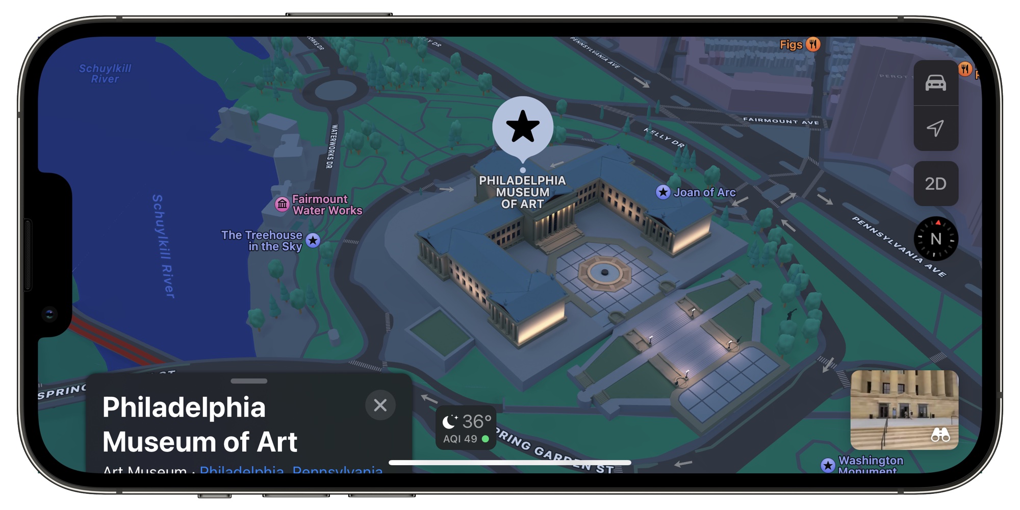
According to Dorn, there are three major reasons why Apple Maps is the best choice.
Apple's effort into improving the Maps app can be seen in iOS 15, an update that added new 3D city details in select areas like London, New York, Los Angeles, and the San Francisco Bay Area. There are also navigation updates that add more detail at complex interchanges. Frost said that Apple wanted to make maps "both safer and visually satisfying to navigate."
- Apple is making serious investments into Maps to improve it.
- Privacy is central and Apple isn't tracking your location for data purposes when you use Apple Maps.
- Maps is part of the Apple ecosystem and integrates well with other Apple devices and services.
As for the 3D landmarks added in the update, each landmark is created by hand. "We pick the amount of detail we find appropriate and create a 3D mesh of the building landmark itself. And we apply it to the base map," Frost told CNN.
The full Apple Maps interview can be read over on CNN's website, and it provides more detail on features like Share ETA, CarPlay, real-time AR walking directions, and more.
Article Link: Apple Exec Explains Why You Should Use Apple Maps

As has been previously raised: lack of cycle option and mutilple destination.
Apple Maps Product Lead David Dorn and Design Lead Meg Frost recently did an interview with CNN to explain the Apple Maps features that were introduced with the iOS 15 update and to explain why iPhone users should choose Apple Maps over other mapping apps like Google and Waze.
According to Dorn, there are three major reasons why Apple Maps is the best choice.
Apple's effort into improving the Maps app can be seen in iOS 15, an update that added new 3D city details in select areas like London, New York, Los Angeles, and the San Francisco Bay Area. There are also navigation updates that add more detail at complex interchanges. Frost said that Apple wanted to make maps "both safer and visually satisfying to navigate."
- Apple is making serious investments into Maps to improve it.
- Privacy is central and Apple isn't tracking your location for data purposes when you use Apple Maps.
- Maps is part of the Apple ecosystem and integrates well with other Apple devices and services.
As for the 3D landmarks added in the update, each landmark is created by hand. "We pick the amount of detail we find appropriate and create a 3D mesh of the building landmark itself. And we apply it to the base map," Frost told CNN.
The full Apple Maps interview can be read over on CNN's website, and it provides more detail on features like Share ETA, CarPlay, real-time AR walking directions, and more.
Article Link: Apple Exec Explains Why You Should Use Apple Maps
I’d use Apple Maps a lot more if it would remember to open to satellite view by default, and if the search box (and associated empty space/history) didn’t take up almost half the screen by default every time you open it on phone or iPad. Why does it have to be SO obtrusive vs a simple collapsed box I can summon when it’s needed?
Apple Maps has worked great for me. Yes, it doesn't seem to know as much POIs as Google Maps and there are some areas that are not quite fully mapped. For instance, we were in Kauai recently and we were in the Costco area heading to one of the farmers' markets - Apple Maps had me going in an infinite loop between Costco and the Nuhou roundabout. 🙃 I had to switch over to Google Maps to finally get to the Grove farmers' market 😆
contacos
macrumors 604
Exactly. Apple Maps (like Google) the mapping data from TomTom/TeleAtlas, still there's this significant delay in updates. In my experience the biggest changes, especially highways, usually appear within 3 months in my TomTom. Google follows and 6-12 months later Apple.
A few years ago I had a nice conversation with a TomTom/TeleAtlas technican and he told me that updates greatly relies on the local authorities. Where very big road constructions usually are announced way in advance, smaller ones are not. Some cities send out the changes very quick, some slow and/or incomplete. Some of the biggest cities can be very sloppy, so he said. It varies throughout Europe, and amazingly sometimes some of the poorest regions of Europe can be very accurate in reporting roadworks and some of the richest cities with enough manpower still very sloppy.
One thing I'm still waiting to see more progress on is: parking data. TomTom is developing a (street) parking data service for more than 8 years now, but so far it doesn't seem to be available for the general public.
Whenever you set a destination now in any navigation app or device, you usually get one or more suggestions for a parking nearby. But you'll have no guarantee that there is actually a free spot when you arrive. Wouldn't it be nice if you click on a parking suggestion that a spot will be reserved as soon as you get near? Maybe even automatically pay through Apple-pay afterwards?
Yes indeed. Parking is very behind on either App. I usually search for the term parking but then u get so many options and the entry is actually barely ever where the pin is located
Canyda
macrumors 65816
I'm pretty much on Apple Maps full time now, especially when I'm just driving around the city (Edmonton). Given Apple mapped all of Canada a couple of years ago, I find it's as good as or better than Google in terms of road accuracy. The reporting traffic incidents in CarPlay is a feature Google (surprisingly) does not have. And I just prefer the way it looks on my CarPlay screen compared to Google.
psac
macrumors 6502a
The one simple item I dislike about Apple Maps is that it treats all roads as equal. The navigation system in the Audi MMI colors major roads differently from small side streets, so I know the difference. That makes major intersections much easier to recognize and find and give me a feel for where I am much better than everything looking exactly the same! When I use Carplay in my wife's car, Google Maps comes much much closer to this than Apple Maps.
I live in a suburb area that's growing really fast. For the last two years, multiple buildings came up near my house. Google Map's satellite is quick to update and show those buildings. Apple Map's satellite has yet to show a single building on that area. It looks like the Apple Map satellite data is at least two years old on my area. If the biggest company on Earth indeed made a serious investment into Maps, I would think their photos were updated sooner.