Become a MacRumors Supporter for $50/year with no ads, ability to filter front page stories, and private forums.
Awesome! Seeing Boston in my Maps. The final piece of the puzzle for me. It's pretty nice what Maps has turned into in a few years. Sure, it was pretty awful when it came out, but it's matured pretty well in the timeframe.
 
I'd be happy if Apple Maps would fix this stupidity - not offering a route to drive to Wisconsin through Chicago????

And soon the ferries won't be sailing anyhow.


GrandRapidsToOshkosh.png


As part of its efforts to add transit directions in iOS 9, Apple has recently updated Apple Maps to include multiple Amtrak routes in the Northeastern United States. Available mainly in the cities where transit directions have been implemented, the longest Amtrak route available runs from Chicago to New York.

Supported routes include the Northeast Regional, Acela Express, Keystone, Lake Shore Limited, Pennsylvanian, and Maple Leaf, many of which operate between cities in the Northeastern United States.

applemapsamtrak.jpg

The Acela Express, for example, runs between Boston, New Haven, New York, Philadelphia, Baltimore, and Washington DC. Lake Shore Limited runs from New York/Boston to Albany to Chicago, while Maple Leaf runs from New York to Niagara Falls to Toronto.

Amtrak routes in the South, West, Midwest, and Northwest are not currently available in Apple Maps, but the information will likely be implemented as Apple expands transit information to additional areas across the United States. Transit directions are 
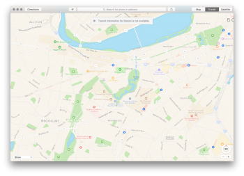
currently available in Baltimore, Boston, Chicago, New York, Philadelphia, Washington, DC, and San Francisco.

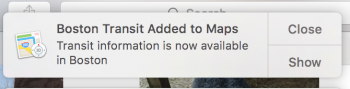
Along with Amtrak support for several cities where transit directions are supported, Apple has also added transit information for the Boston area. Boston was initially added to Apple's list of supported cities earlier this month, but the page was later updated to note the feature wouldn't officially be working until a later date in October.

As of this morning, transit directions are available in Boston, allowing Boston residents to access directions by Amtrak, commuter rail, buses, and more. The next city to gain transit directions will be Sydney, which was also added to Apple's list of supported cities earlier in the month. While Boston transit information is live, it does not yet appear to be available in Sydney.

(Thanks, Alec!)

Article Link: Apple Maps Adds Amtrak Routes in Northeastern U.S. and Transit Directions for Boston
 
Unreal. If only Amtrak had like a website or a mobile app or something where I could figure out which train to take without using AppleMaps.

I have a folder of non-removable Apple apps on my phone, called "Apple Cr@p." My teenager saw it and thought it was funny and did that too and now all her friends have "Apple Cr@p" folders. Apple should leave apps to developers. Most of the native apps on iOS are cruddy at best, bloatware at worst. Apple Maps shouldn't have seen the light of day until it was at least modestly competitive with Google Maps (and Waze, the best app ever). It still isn't even close. I guess what do you expect from people who want to work in a circular building . . . no need for a map.

It really is a hobbled, crippled, ugly, often wrong map application, even after all these years.

Has anyone even used "Apple News" yet? Another hilarious joke.
 
Transit directions are spot on in Boston. This is the first Transit routing app that gets my commute correct.

My commute is funky because I live near an outbound only bus stop... so in the morning I actually catch an OUTBOUND bus... and ride it around until it becomes an inbound bus and makes its way to the nearest subway station.

Every other transit app has me start my commute by walking a mile or so to catch the same bus at an inbound stop. It would technically work... but it's not ideal. Apple Maps nails it exactly right.

Another cool side effect of Transit directions coming to Apple Maps is that any apps that depend on that capability now just came alive in Boston. One of those is ETA. I bought it because it looked cool... only to find out that it relies on Apple Ttansit directions... but just yesterday it started working in Boston!
 
um, I quoted from the US census bureau - that's not personal opinion, unless a US Federal Agency can have a personal opinion. :rolleyes:
i was referring to the person you were referring to. regardless, in any/all cases, geographic regional labeling is subjective. if we need an end-all-be-all arbiter of geographic groupings, i'll go with the ATF's wine region map used for legal descriptions of winery locations on bottles. yes, we regulate that...
 
i was referring to the person you were referring to. regardless, in any/all cases, geographic regional labeling is subjective. if we need an end-all-be-all arbiter of geographic groupings, i'll go with the ATF's wine region map used for legal descriptions of winery locations on bottles. yes, we regulate that...
I had no idea the ATF regulated that.

Still, anything with wine sound mighty fine! :D
 
Funny how this isn't showing up on ANY of my Apple Devices, either under iOS9 or El Capitan. "Transit information for Boston is not available."

Same. I'm still getting "transit for Boston is unavailable." On all my devices, after a few unrelated restarts.

Anyone still seeing the same thing?
 

Attachments

  • Screen Shot 2015-10-20 at 3.53.03 PM.png
    Screen Shot 2015-10-20 at 3.53.03 PM.png
    2.3 MB · Views: 93
Stick to Google Maps. Beta testing is nice but getting to where I need to go is much more important!

Agreed. I like how Google maps now can be in your notification screen. Just swipe down and you get all the bus routes close by.
 
Guess I left the maps app open overnight because I just logged in, and found this Yay, finally!
 

Attachments

  • Screen Shot 2015-10-21 at 9.41.24 AM.png
    Screen Shot 2015-10-21 at 9.41.24 AM.png
    3.1 MB · Views: 124
Transit directions in Boston seem to have one huge shortcoming. In spite of the fact that MBTA makes live data available for developers to use real time tracking, Apple Maps seems to only use scheduled times. With buses seldom running actually on schedule, this eliminates any value transit maps might have.
 
Well - there are a thousand dedicated bus timing apps out there (my favorite is OKCommutor - maybe just because I'm a big Radiohead fan :)

I don't use Google Maps or Apple Maps for detailed bus / train arrival time... I use it for general route planning (take bus 77 to Harvard, Red Line to Park Street, then walk, etc).

Dedicated Apps are better once you know where you're going...
 
BTW: For anyone in the Boston area that takes the T... You MUST get the app called ProximiT !!! It uses geofences to know when you're walking towards a T stop... and automatically gives you a notification about how long it's going to be for the next train.

Basically: it tells you if you should hurry down into the T stop or if you can take your time.

With the Apple Watch it is freaking amazing. Taps you on the wrist as you walk towards the station... you raise your wrist and instantly see how long until the next train. Feels super futuristic!
 
Apple sending out notifications about it:
 

Attachments

  • Screen Shot 2015-10-22 at 8.48.26 AM.png
    Screen Shot 2015-10-22 at 8.48.26 AM.png
    86.6 KB · Views: 134
Register on MacRumors! This sidebar will go away, and you'll see fewer ads.