Become a MacRumors Supporter for $50/year with no ads, ability to filter front page stories, and private forums.

MacRumors

macrumors bot
Original poster
Apr 12, 2001
67,489
37,771


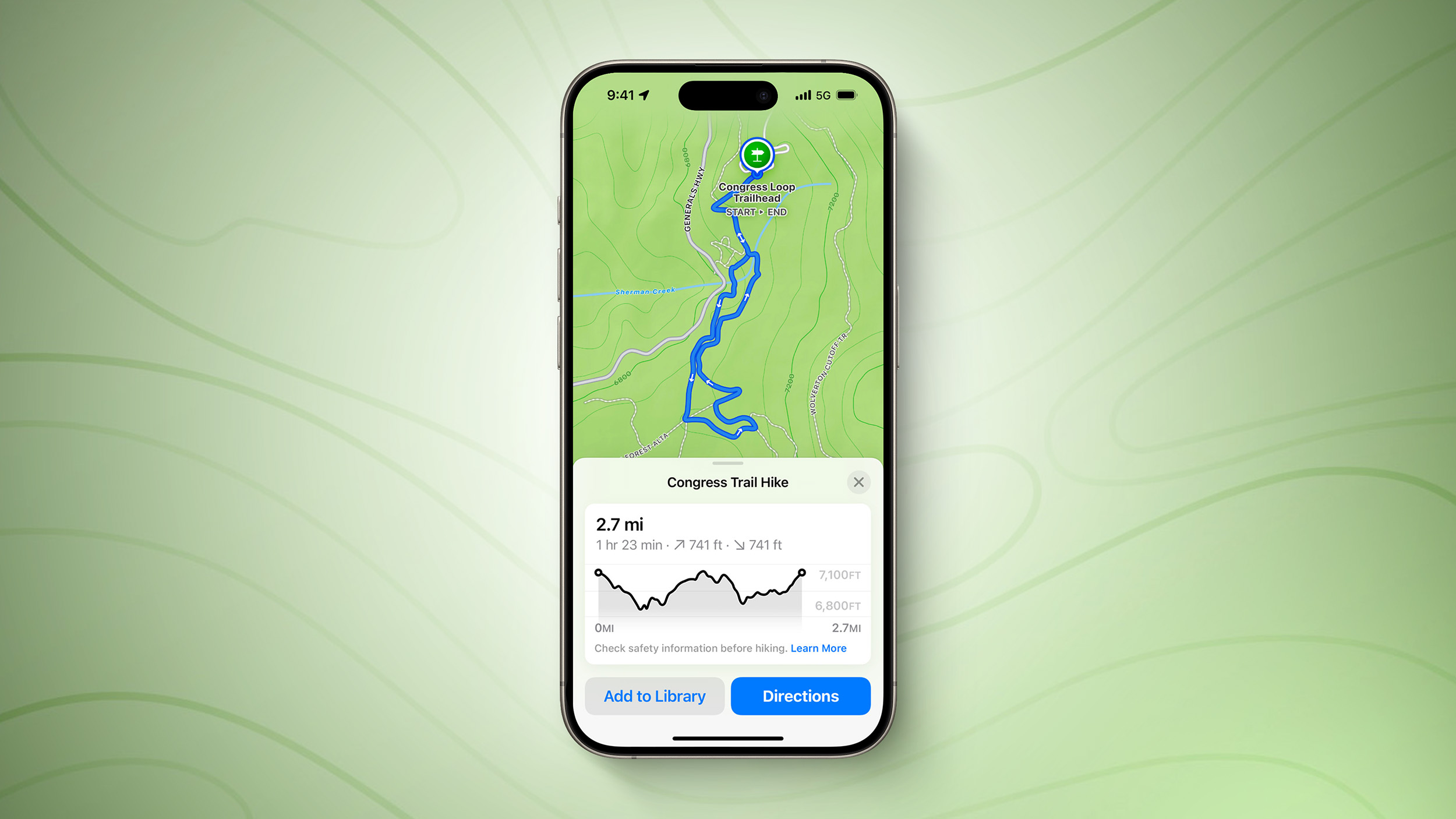
Just months after naming AllTrails the iPhone App of the Year in 2023, Apple has added new hiking features of its own to the Maps app on iOS 18.
iOS-18-Hiking-Trails-Feature.jpg

Apple Maps users in the U.S. can browse thousands of hikes across all 63 national parks in the country, filtered by length, elevation, and route type. Users can also create and save their own custom walking and hiking routes, with one-way, out-and-back, and loop routing options to choose from where available.

Apple Maps added topographic maps on the Apple Watch with watchOS 10 last year, and these maps are now available on the iPhone too with iOS 18. Topographic maps and hikes can be saved for offline access with turn-by-turn voice guidance.

These features are mostly limited to the U.S., but topographic maps are also available in Japan, according to fine print on Apple's website.

Here is how Apple describes all of the features:
Apple Maps introduces even more ways to explore the world, including hikes and custom walking routes. Users can browse thousands of hikes across national parks in the United States — filtered by length, elevation, and route type — and save them to use while offline. Users can also create their own custom walking routes with just a few taps to plan everything from a local exercise route to a full-day walking tour in a new city. Additionally, they can save their favorite national park hikes, custom walking routes, and places to an all-new Places Library, and add personal notes about them.
MacRumors contributor Aaron Perris exclusively revealed that these features were coming to Apple Maps on the iPhone earlier this year.

iOS 18 is currently in beta and should be released in September.

Article Link: Apple Maps Rivals AllTrails on iOS 18 With New Hiking Features in U.S.
 
Cool. We pay for AllTrails, and "free" would be nice.

Note to Apple (or AllTrails): make a pay version available that includes satellite access... often when we're on trails we're off network. (AllTrails has downloaded maps, which we use, but are they accurate?)
 
Apple (or AllTrails): make a pay version available that includes satellite access... often when we're on trails we're off network. (AllTrails has downloaded maps, which we use, but are they accurate?)
All trails is plenty accurate. I tested it alongside a Garmin Edge 1040 cycling computer and my Fenix 6 watch. All of them work fine with just GPS. Apple Maps (downloaded) HOWEVER was always WOEFULLY inaccurate. When trying to get driving directions to a well-known trailhead I compared Waze, Google Maps and Apple Maps. The first two nailed it with Waze offering a crazy shortcut as it often does. Apple Maps wanted me to go 40 minutes in the wrong direction into town. These are common trials, well-traveled roads and all of it in or near a national park and daily populous city. Outside cities Apple Maps continues to be an also-ran option (and even still there are issues). We aren’t talking about remote locales either. It’s sad.
 
Perhaps Apple should also focus on the rest of the world. It’s so damn annoying that’s lots of features don’t make it to everyone right from the get go
I mean, the world is a big place. Especially when the task is mapping. It’s hard enough to roll any product out globally, let alone one that literally details the surface of the planet.
 
I mean, the world is a big place. Especially when the task is mapping. It’s hard enough to roll any product out globally, let alone one that literally details the surface of the planet.
Apple is the most valuable international company on the planet .
 
Perhaps Apple should also focus on the rest of the world. It’s so damn annoying that’s lots of features don’t make it to everyone right from the get go
I imagine they focus on the areas with the largest iOS user base first.
 
I spent a few hours trying this out, and it's not a serious threat to AllTrails until it provides hiking routes outside of the 63 national parks. Or worldwide.

I will say that if you zoom in far enough to see trails or roads, the feature that allows you to plan your own route works fairly well for a first beta.
 
Can anyone from central or Eastern Europe confirm is Apple Maps has gotten any better? I swear to god, I have no other choice but to use Google Maps. Apple Maps leads me through ghettos and through the roads that are no longer accessible
 
AllTrails has conditions reports, reviews and ratings. Garmin is crazy accurate. This will be a superficial stab at low hanging fruit competitors have on offering but in true Apple fashion it’s wide as a barge and shallow as a thimble. Just look at their drip feed of new fitness conditioning like what Garmin has had for years and does much better. I did notice the health app copied Garmin connect this year. Same reason none of the cycling or tri folks I know ever seriously considered something other than Garmin Suunto or Coros.
 
Last edited by a moderator:
AllTrails biggest selling point is user-generated content, being able to find unofficial routes and read reviews to determine conditions. Apple, for whatever reason, doesn’t engage in user-generated content, so this will never be a serious competitor to AllTrails.
 
Last edited by a moderator:
Can anyone from central or Eastern Europe confirm is Apple Maps has gotten any better? I swear to god, I have no other choice but to use Google Maps. Apple Maps leads me through ghettos and through the roads that are no longer accessible

In Germany it is working fine but it’s completely useless to get an idea of Points of Interests based on ratings / reviews because it relies on Yelp, which basically no one uses here
 
I mean, the world is a big place. Especially when the task is mapping. It’s hard enough to roll any product out globally, let alone one that literally details the surface of the planet.
That’s code word for they either can’t or won’t. All that’s left to argue over is the reason why.
 
  • Like
Reactions: arkitect
AllTrails biggest selling point is user-generated content, being able to find unofficial routes and read reviews to determine conditions. Apple, for whatever reason, doesn’t engage in user-generated content, so this will never be a serious competitor to AllTrails.
Could definitely see Apple Maps being a "good enough" product for casual users, but totally agree -- people who do this a lot and really want to engage will probably find it worth AllTrails.
 
So far the trailheads that I have saved on AM to remember the locations don't seem to work or are integrated with this feature. It's not super intuitive imo, or useful out of the gate. I could be using it wrong of course, but the whole thing with Apple is the intuitive nature of the software/product. We'll see....
 
Full disclosure, I don't use AllTrails for the actual navigation for this reason:

AllTrails offers an Apple Watch app that can be used in conjunction with our iPhone app. The watch app allows you to control and view activity stats directly on the watch screen while using Navigator to follow your route. The Apple Watch app is not a standalone app, therefore it requires your phone to be present for the watch app to function.

I export the GPX files from AllTrails and import them into something like Footpath or WorkOutdoors so that I can follow the route and get directions without needing my phone.
 
Last edited:
In Germany it is working fine but it’s completely useless to get an idea of Points of Interests based on ratings / reviews because it relies on Yelp, which basically no one uses here

No one I know here in San Francisco, the home of Yelp HQ, uses Yelp anymore. That company was known to be corrupt 15 years ago (sleazy sales tactics offering to remove negative reviews if a business purchased ads on Yelp, for one example), and over the last decade review traffic has dropped to a small fraction of what it once was. Google seems to have eclipsed Yelp for customer reviews.

I’ve been surprised that Apple Maps has retained its connection to Yelp for so long, it’s long past time for Apple Maps to drop it and move on.
 
Perhaps Apple should also focus on the rest of the world. It’s so damn annoying that’s lots of features don’t make it to everyone right from the get go
Perhaps you could start your own company and do this? You see a need. Jump in there and fill the gap. You could make a fortune.
 
Register on MacRumors! This sidebar will go away, and you'll see fewer ads.