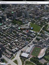
These 3D models are generated by flying specially equipped aircraft (not sure if they're using helicopters or fixed wing aircraft?) in specific patterns over the cities being models.
With London, at least, the airspace over the central city is strictly controlled. It's generally off-limits to private flights. Commercial carriers require permits and must fly in special pre-defined routes/lanes. No doubt, similar restrictions apply to other major cities like New York and Tokyo.
While I'm sure Apple can get special permission to fly their mapping patterns, its probably quite arduous to do so. I can imagine starting with "easier" and less restrictive cities while they're still working the kinks out, and will move on to places like London once they're sure they've got the technology mastered.

![IMG_1528[1].PNG](/data/attachments/295/295627-842f74bad9d040850cec503530823b5a.jpg?hash=hC90utnQQI)


![IMG_1529[1].PNG](/data/attachments/295/295649-032ee339b7ea52f20e76992cfb63a4f8.jpg?hash=Ay7jObfqUv)
![IMG_1530[1].PNG](/data/attachments/295/295650-b80e304c16d621cd1c4ffca8ed104481.jpg?hash=uA4wTBbWIc)