The other "maps" threads seem to be a little too general and I thought I would start a thread just for turn-by-turn info, thoughts, criticisms, praise, etc.
I've only been using it in my local area for a week now...everywhere I drive....just to try it out. Thoughts so far:
* For me, I love the graphic interface (USA). Signs match local graphics, easy to read, like the name of the road I'm on listed below the arrow, shows important cross streets as I drive as legible points and not on the map itself...
* Would love the brightness/graphics to adjust based on day or night. As the days get shorter, I usually leave for work when it is dark and the "bright" screen graphics are a littl much in my dark cabin.
* Not sure if this is related to 4G or he software, but redirections have been nearly instantaneous. I have purposefully taken different routes than suggested to test it out and it usually has the next suggestion before I finish the "wrong" turn.
* Location was off slightly last couple of times I used it...my position on the map seemed to be a couple of hundred feet behind where I actually was. Wondering if it wasn't off enough to reset since it.
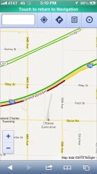
* I've been a Garmin user my whole life and the iPhone (TomTom) seems to be picking routes that are actually better than what my GPS would. I always hated that it would take me to the street I wanted to go to, but on a route that has traffic lights or actual speeds that are typically slower than what is posted. The phone has already utilized two different routes that I always thought might be faster...and they were!
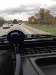
* I use a windshield mount and charge in my car. The first day I didn't and the battery life seemed to shrink dramatically. Nice to have my phone charged when I get to work/home.
Any other thoughts, suggestions, etc.? And save your "maps sucks" comments to the other threads...just looking for turn by turn tips, suggestions, etc.
I've only been using it in my local area for a week now...everywhere I drive....just to try it out. Thoughts so far:
* For me, I love the graphic interface (USA). Signs match local graphics, easy to read, like the name of the road I'm on listed below the arrow, shows important cross streets as I drive as legible points and not on the map itself...
* Would love the brightness/graphics to adjust based on day or night. As the days get shorter, I usually leave for work when it is dark and the "bright" screen graphics are a littl much in my dark cabin.
* Not sure if this is related to 4G or he software, but redirections have been nearly instantaneous. I have purposefully taken different routes than suggested to test it out and it usually has the next suggestion before I finish the "wrong" turn.
* Location was off slightly last couple of times I used it...my position on the map seemed to be a couple of hundred feet behind where I actually was. Wondering if it wasn't off enough to reset since it.
* I've been a Garmin user my whole life and the iPhone (TomTom) seems to be picking routes that are actually better than what my GPS would. I always hated that it would take me to the street I wanted to go to, but on a route that has traffic lights or actual speeds that are typically slower than what is posted. The phone has already utilized two different routes that I always thought might be faster...and they were!
* I use a windshield mount and charge in my car. The first day I didn't and the battery life seemed to shrink dramatically. Nice to have my phone charged when I get to work/home.
Any other thoughts, suggestions, etc.? And save your "maps sucks" comments to the other threads...just looking for turn by turn tips, suggestions, etc.