Become a MacRumors Supporter for $50/year with no ads, ability to filter front page stories, and private forums.

MacRumors

macrumors bot
Original poster
Apr 12, 2001
65,992
34,801


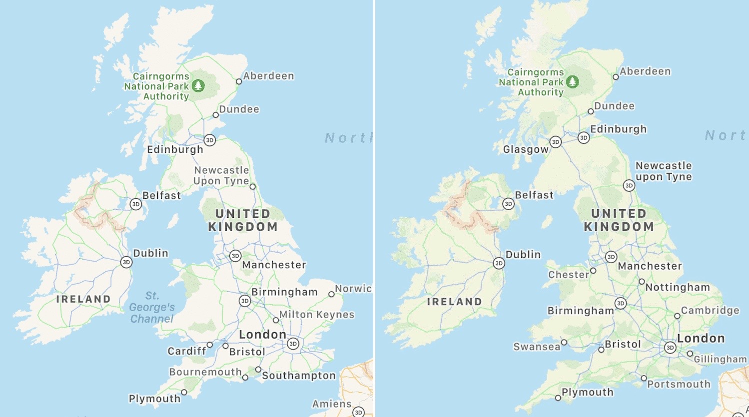
Apple has reportedly begun testing an expansion of its more detailed Apple Maps app in the United Kingdom and Ireland, according to Justin O'Beirne, who often shares details on updates made in ‌Apple Maps‌.

UK-Ireland-Apple-Maps-Revamp.jpg
Image via Justin O'Beirne

Since the Maps revamp in these countries is in testing stages, it is worth pointing out that the changes are not available to all users at the current time.

Apple announced at its virtual WWDC 2020 event that the new Maps app would be coming to the United Kingdom, Ireland, and Canada "later this year," but no clear date was given as to when the rollout would be completed.

The revamped Maps app features richer landscape details such as roads, parking lots, parks, buildings, airports, and more. Apple uses its own vehicles equipped with LiDAR sensors and cameras to obtain mapping data.

Apple worked for over a year to complete the rollout of the new Maps app in the United States, and the process concluded in January with the expansion to the Southeast and Central United States.

Article Link: Apple Begins Testing Revamped Maps App in UK and Ireland
 
  • Like
Reactions: 19callum93
With maps becoming ever-more detailed, it makes me wonder how LIDAR can discriminate between a statue and a bloke stood at a bus stop staring into the abyss?

It can’t. But all Apple Maps images are passed through an AI filter that blurs out things like human faces and car number plates, in a similar manner to that employed by Google Street View.

If you check out Look Around in Times Square, New York, you will find that the statue of George M Cohan “staring into the abyss” has a pixelated head :)
 
Apple really needs to put some on the ground resources into this. The leadership has obviously decided not to though. The roll out of any announced feature takes years. On such an essential app it is pretty ordinary TBH.

It’s like all they have is some old guy and his dog slowly wandering the world getting the data for an update. And his attitude and approach to work is retired in place.
 
It can’t. But all Apple Maps images are passed through an AI filter that blurs out things like human faces and car number plates, in a similar manner to that employed by Google Street View.

If you check out Look Around in Times Square, New York, you will find that the statue of George M Cohan “staring into the abyss” has a pixelated head :)

I'm thinking less of "look around" (where people would be present) and more of the actual mapping/cartography, where moving objects are not shown at all but increasingly, human-sized objects are.
 
Apple really needs to put some on the ground resources into this. The leadership has obviously decided not to though. The roll out of any announced feature takes years. On such an essential app it is pretty ordinary TBH.

It’s like all they have is some old guy and his dog slowly wandering the world getting the data for an update. And his attitude and approach to work is retired in place.

This. ^

Compared to that >

 
Google maps seems more detailed.
But if you compare them closely, you will notice that Apple sometimes has partly overtaken Google...
After all, Apple is investing a lot of money, because these maps will be the new basis for some of their future projects.

Someone who has no idea how much effort it takes to create maps will always complain about the slowness of the creation process. Out of naivety and attitude to life. You're different there, dear Theyayarealivin.
 
Last edited:
Used Apple Maps in CarrPlay yesterday (in girlfriends car with her phone). I noticed that the map looked a lot better and clearer.

I wonder if that is because she has the new maps, or just me not remembering what maps were like as I’ve not used it in ages.
 
  • Like
Reactions: scgf
Apple is a small company with very rare resources so I can’t imagine them doing a lot of work quickly /s

I still don’t understand why they can’t do this enmass, like hire a fleet of cars (especially during COVID) to do this world wide

"Hi, is that Hertz? This is Apple here. Just wanted to check how many LIDAR- and camera-equipped cars you have available to hire. Oh, I see. Thanks anyway. Bye!"
 
Apple is a small company with very rare resources so I can’t imagine them doing a lot of work quickly /s

I still don’t understand why they can’t do this enmass, like hire a fleet of cars (especially during COVID) to do this world wide

A fleet of cars is a tiny part of a much larger organization. It took Google almost a decade and thousands of employees/contractors around the world to complete the migration from 3rd party maps to its own product. They were still working on Western Europe (which was their second continent after North America) around 2012-13. 10 years is not a long time to map a large portion of the world and Apple only started it about two years ago.
 
I‘m eager to use cycle lane routes. I’m having to use pedestrians routes for riding atm, so I’m constantly having to battle with stairs and the most annoying thing by far is the auto switch to driving bug (feature?) that I hate with a passion.
 
  • Like
Reactions: klm9210
I‘m eager to use cycle lane routes. I’m having to use pedestrians routes for riding atm, so I’m constantly having to battle with stairs and the most annoying thing by far is the auto switch to driving bug (feature?) that I hate with a passion.

I believe there is a setting that allows you to choose your preferred method of directions in Maps.

If you’ve tried that and it is still reverting to driving then I think you’ve found a bug!
 
  • Like
Reactions: dreyp82
Looks like Glasgow and Newcastle now get 3D. Apart from that, there is more green shading on the map.
 
Register on MacRumors! This sidebar will go away, and you'll see fewer ads.