Become a MacRumors Supporter for $50/year with no ads, ability to filter front page stories, and private forums.

MacRumors

macrumors bot
Original poster
Apr 12, 2001
68,703
39,622


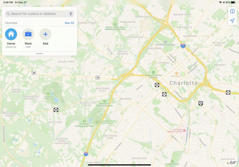
Apple in December began testing an expansion of its more detailed Apple Maps app in the Central and Southeastern parts of the United States, along with Alaska, and that updated Maps content is now rolling out to all customers.

The revamped Maps app features more extensive geographical details, with updated buildings, roads, parks, sports fields, parking lots, foliage, pools, pedestrian pathways, and bodies of water.
newmapsappsoutheast-800x559.jpg

To get its mapping data, Apple uses its own vehicles equipped with LIDAR sensors and cameras. Apple has been using this method to collect mapping information for years now.

Apple began rolling out its updated mapping app to customers starting in iOS 12, and at the 2019 Worldwide Developer Conference, Apple said all customers in the United States would receive the improved Maps app by the end of the year.

Apple has made good on that promise with the rollout of the new mapping terrain to large swathes of the United States, and the updated Maps are now becoming available across most of the country. It could still take some time for all users in the Central and Southeastern areas of the U.S. to see the new content. Apple plans to bring the new Maps app to additional countries in 2020.

(Thanks, @tricil and @NateThompson!)

Update: Though Apple has begun releasing the new mapping updates across the United States, updated Maps features are not yet showing up for all users in the Southeast at this time.

Update 2 -- Jan 30, 2020: The rollout of revamped Apple Maps in the Southeast and Central United States now appears to be complete. This includes the addition of traffic lights and stop signs in Apple Maps on CarPlay.

Article Link: Revamped Apple Maps Expands to the Southeast and Central United States [Updated]
 
Last edited:
  • Like
Reactions: jpn and jjm3
Just a little :) Or at least a bit of a clarification.
I always check this page for the best maps information. According to this site, they're just in testing, so some will see the changes, sone won't. So, the data capture may be considered complete, but the rollout is not complete until everyone has it.


Yeah, I know. There's a thread about Apple Maps here on this very forum which I follow (along with the page you linked).

They started testing this new expansion on December 18, and then it was pulled from people who had it, only to apparently be doing public testing of it again.

MacRumors (I think) usually waits until it goes public before posting a story on it.
 
  • Like
Reactions: Sasparilla
The single thing that's kept me from switching away from Google's maps is that Google's display of traffic congestion information is easier to grok at a glance. Google adopted the standard green-yellow-red-black paradigm most of the older traffic display systems used, and it's just easier to quickly comprehend.

I notice that, with the revamp, Apple's at least gotten rid of that annoying system of dashes they used to use. But still, it seems like they're trying to be different just for the sake of being different, and sacrificing quick visual interpretation because of it.
 
I love the look and detail of Apple Maps but the fact that I can hit a button in Waze and get 3 updated route options at any time keep me going back to Waze (I live in a very congested area in northern NJ and rush hour commutes can be brutal). Until Apple Maps can do that I'll be sticking with Waze
 
The single thing that's kept me from switching away from Google's maps is that Google's display of traffic congestion information is easier to grok at a glance. Google adopted the standard green-yellow-red-black paradigm most of the older traffic display systems used, and it's just easier to quickly comprehend.

I notice that, with the revamp, Apple's at least gotten rid of that annoying system of dashes they used to use. But still, it seems like they're trying to be different just for the sake of being different, and sacrificing quick visual interpretation because of it.

Or maybe Apple prefers to show traffic and not LACK of traffic (green) like Google.
 
“Completing rollout”.
time for Apple’s monthly reminder that there are 195 countries on the planet. Hi from Australia.

"Completing rollout" is a headline from MacRumors alluding to Apple's rollout of the U.S. by the end of 2019.

More countries are being added next year, with Europe and Canada most likely being the most likely places added next since they have been actively spotted gathering data for an upcoming rollout.
 
Or maybe Apple prefers to show traffic and not LACK of traffic (green) like Google.

Here’s one problem, though. How do you determine the difference between “traffic is good everywhere in my immediate vicinity” from “the map isn‘t displaying traffic data yet”? I suppose the former never happens in Cupertino, but it’s not unknown within the mile or two around my house.

Right now, where I live, the Google traffic map in my immediate vicinity is all green - at a glance I know there are no issues. With the Apple map, I have to expand it a few times until I see some areas displaying congestion - only then do I know for sure there’s not a data issue.
 
Register on MacRumors! This sidebar will go away, and you'll see fewer ads.