Yeah, no net and work stops play…And finding out I might have a masseeve "no tethering in your T&C" mobile phone bill

Am definitely a convert to tethering now. But then With BT Openzone, and BT Fon for me kicking in mid July, It just makes it more juicy. Whether O2 have the kindheartedness to pitch a decent priced alternative to having no tethering for iPhones remains to be seen.
For just this post, a quick re-look at the possibilities that the 3G iPhone might bring. Courtesy of OlsonBW’s post (the 8th post) from
here.
Basically, OlsonBW fleshed out the concept of a golfing app. My addition to it, would be when Panoramio goes beyond the Street View shackles, and we start seeing decent collaging of non-road areas, and the ability to basically move around a city via photos like you had a blinking problem.*
Basically make a community driven Photosynth. A flickr meets Google Earth. So Panoramio could provide a "better than"/complementary to street view style panoramic views (Till Google starts buying up small scale robots to do the non-road sections of a city (e.g. Trafalgar Square, London).
So you take lots and lots of shots of the golf course. Then shove them up into the cloud. Then, Photosynth/Panoramio/other deals with them, then you can view the golf course
1) With various bird’s eye views – e.g. satellite view, or a layered nice map view overlaid on the normal google map view. So you add a layer with all the bunkers and green info.
2) A Ground level photosynth view.
Why? Because golf players like to improve their game. A lot. Any way. By actually using geolocation features and also potentially a transit based system, you could plot where each shot went. Look at the map, see where to angle your shot over the horizon in the panoramio view, then take the shot, and then geolocate the ball when you get to it. You could then use the data after playing a few rounds to see if you're taking the best line, or hooking your shots etc (you could have a shot by shot pull down comment system (hooked, sliced, in line with where you wanted it to go etc). Then look at the data - a kind of motionbased.com for golfing. you could also use it for scorecards, and push them to the clubhouse, get feedback on what you've played recently, or analyse your previous 20 rounds of golf, and see how you normally do on a hole etc.
you could add data on club choice too. And presumably, you could actually get a simple predictive you want this iron analysis 9 - it knows where you are, so it can give you an accurate distance to hole judgment - you could also use it to measure longest drive with a driver. Loads of potential.
*There is software out there that can interpolate, and create images from other ones –The Matrix is a good example, when they were using bullet time, and through the ground-breaking camera rigs, were then able to create video from the stills. It’d be interesting to see what power level was needed, and whether you could shunt te work to a GPU. Certainly creating 3D models from multiple photos exists, and an offshoot of Photosynth/Panoramio could be in creating 3D models of places (a pie Google already has a finger in), with then morph on the photos to (a little akin to skins in computer games).
Thoughts
What standard is Apple going to use to get devices to communicate? Are cameras moving towards Bluetooth? The thinking being, if cameras could pair with an iPhone, the camera could then become location-aware, and geotag via the iPhone for example. GPS hardware or interaction capability exists on the more expensive cameras, but they could trickle that down if they were able to use a Bluetooth or similar wireless communication system to link devices.
iPhones as UI devices
Just mocking up something simple, so apologies for the roughness. Having recently seen the 3Dconnexion SpaceNavigator, which looks useful in the CAD/design/ Google Earth arena, I thought I’d revisit the concept of iPhone as multi-touch UI for Apple laptops and desktops. This is partly with a head nod to the work on getting other multi-touch systems working, like Flux, and how the iPhone could be used in physical proximity to the keyboard and mouse, and be an accompanying device. Feel free to smarten up my rough description with better more visual mockups
basically, take the concept of a iTablet docking into a iMac, and convert that to a horizontal version, where it's an iPhone docking into a foam edged dock. Will try and make a better image of it later.
Wacom might be on the cusp of it – Whilst the “Bamboo” is a bit naff for my liking, Wacom have the prerequisites to get something out.
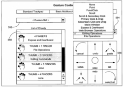
Hope springs eternal. Especially afaik there hasn’t been any more information about new gestures on the iPhone come the 2.0 update come July 11. Sometimes Apple staggers things, sometimes it’s a Kansas City Shuffle/ musical chairs moment, and things get trickled down simultaneously. Surely after a year, we’re ready or more than pinch?
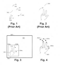
(e.g. Shake and erase, tilt and undo, pitch and delete, tilt and change color palette, a 3 finger gesture for movies – 2nd and 4th finger, with the middle fingersliding down between the 2 to indicate an edit.)
Other uses
The iPhone, has the potential to be a ubiquitous war walking/driving machine, with inbuilt GPS… Theoretically, it could crack WEP itself, as the sums ain’t too hard, or actually store the data dump to crack lharder encryption. Having looked recently at what's available, it seems primarily hindered by Macs and PCs not being able to use the wireless cards they have, and needing special cards, drivers and programs to do most of the groundwork. If that was lifted, it'd sure shift people more to WPA2 and away from open / WEP wireless.
Google Maps, 3G iPhone GPS capabilities, and Digitla map maker Tele Atlas
Tele Atlas, a digital map maker, has announced today a 5 year deal with Google to provide maps.
Tele Atlas was acquired by TomTom. So Google, and iPhone users could potentially be used as a huge map wiki project, being able to point out errors in its maps. A modo cool usage of the group collaborative concept. (Can you guess i'm reading Clay Shirky currently?
)
So users of Google Earth or Google Maps could be able to correct map errors or omissions, (missing street names, wrong road positions etc, and probably VERY usefully, show country roads that brain-dead GPS drivers shouldn't use and get stuck in (van drivers getting wedged/shaving their roofs off...)).
The other digital map maker? Navteq Corp, which Nokia is buying. I think from the collaborative angle, this will rock over Nokia - I feel that people who use Google a lot and iPhone a lot have a lot more brand loyalty and potential energy to help make better the maps TomTom/Google Maps have.
Off shoots of this could be amazing - since it's being linked to Google Earth, you could create your own dmz's - effectively use your iPhone as a surveying tool. Link this in with a Panoramio style system - (which hopefully could have locally stored data) and you have an amazing mapping tool, that could be useful in many guises:
e.g. Archaeology or Geology - you want to look at mapping the area. Rather than paper maps - go digital. By going digital you don't lose out on papaer, as you can always print it out to a plotter, but you're not handicapped by large pieces of paper that are harder to update, and very hard to share easily (A1 printer out in the desert anyone?).
You just blitz the area with a digital camera, photosynth it up, or panoramio it up - stitching the pictures into a virtual wolrd represnetation - then mark ome definitive points very accurately, so you can get scale sorted (maybe having to have a 1 meter rule or somesuch in the picture to get the measurements right) - then boom - you can tag the data, show areas of interest, do quadrants, etc. You could also easily get people back at base in the UK or the US to look at the data, and point out areas of interest (which would be time efficient, as there will be time zone differences).
Yes there is identification of strata, on the ground rock sampling etc - but the actual usefulness comes in having a manageable virtual world when you get back.
For this reason, i'd imagine there could, if it got professional enough (the iPhone could Bluetooth to a more accurate GPS, or laser based system for example) be used in lots of other sorts of mapping, from using to survey houses, to oil drilling sites, all sorts.
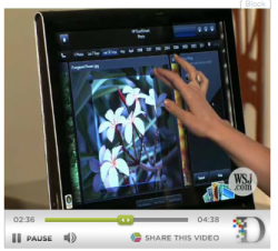
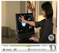
We've seen the graphical power of the iPhone, when the medical demos were shown showing tomography turned into a 3D model, with a range of visualisation (shading by false color, heat, type etc).
Maybe I wasn't able to convince a recent geologist I talked to, but I'd love to see if anyone else knows of one that's more technophilic?
Owners of TomTom devices already submit about 10,000 corrections to maps every day. Many drivers also allow the company to gather anonymous data from their devices on how fast it is possible to drive on a given road at different times of day -- information that can be used to improve routing.
TomTom has amassed 1 trillion data points, equivalent to driving every road in Europe and the United States a thousand times.
Henry would not comment on financial terms but said Google would become a "much more important customer" and that the deal would create more opportunities for Tele Atlas online.
"One of the key growth areas for Tele Atlas ... is the Internet," Henry said.
The map company generated just 8 percent of revenue from its fast-growing wireless and Internet business in 2007.
Tele Atlas said it would not have access to Google's database of mobile phone network cell IDs, which Google uses in its maps application for mobile phones to estimate a user's current location.
De Taeye said he expected real-time, turn-by-turn navigation applications to be available for Apple Inc's iPhone despite reports that Apple's rules for developing iPhone software appeared not to allow it.
"We are making sure that navigation is an application that is allowed," De Taeye said. "If there is any restriction on the platform, that indeed has to do with the restrictions that we have in our contracts. Navigation is allowed, provided that the right fees are paid."
Royalties for real-time navigation are higher than for maps that are just used to display a static location. ($1=.6353 Euro) (Editing by Braden Reddall)