joecomo
macrumors 65816
Thanks to our data-protection zealots, we‘ll never see the update in Germany
I agree. Looking at grid lines does me no good. The map developers need to get out of the Bay Area and visit parts of the world with poor or no cell service.Wow, still no Offline maps download? Pathetic.
Phone turns into a brick when you're out hiking or no reception, damn. 🧱
They are often not accurately calibrated.Does your speedometer not work?
My experience is that Apple fixes reported issues on businesses quite fast. They usually go live on Saturday night and you get a push notification if you requests one. The main issue is that the list of wrong or mislabelled businesses is endless.I run into issues with miss labeled business and roads on Apple Maps. Takes them forever to correct once it’s reported as incorrect.
What do you mean? It’s been there for ages. You can share your real-time location from Messages and Find My.Is anyone using iOS 16 beta along with someone else to see if it has the real-time Location Sharing that was announced a couple of WWDCs ago?
Living in Denmark I expect not to see any of these features. Apple is very limited in their features when it comes to spread it out to more countries. It’s like they develop a feature, include it in the product for the US, set the tick mark that’s it is done and then stop spreading it out to the rest of the world.
For the love of postal workers, please add home numbers to the map, I hate having to go to google maps just to find a set of numbers of homes for a delivery route! And a feature that postal workers can use to quickly and efficiently make a delivery route for 10 packages if been searching the App Store for an app like this. Guess I’ll have to learn to code and make one myself?
The iOS 16 Maps app didn't get as many changes as some of the other apps in the update, but there is at least one major change that's worth noting -- multi-stop routing. Multi-stop routing is a long-awaited Maps feature, plus there are a few other new options.
This guide highlights all of the features that are new to the Maps app in iOS 16.
Multi-Stop Routing
With iOS 16, you can plan a route that has multiple stops for the first time. Prior to now, you could only route yourself to a single location, and the Apple Maps app was far behind competitors like Waze and Google Maps when planning for more than one stop on a trip.
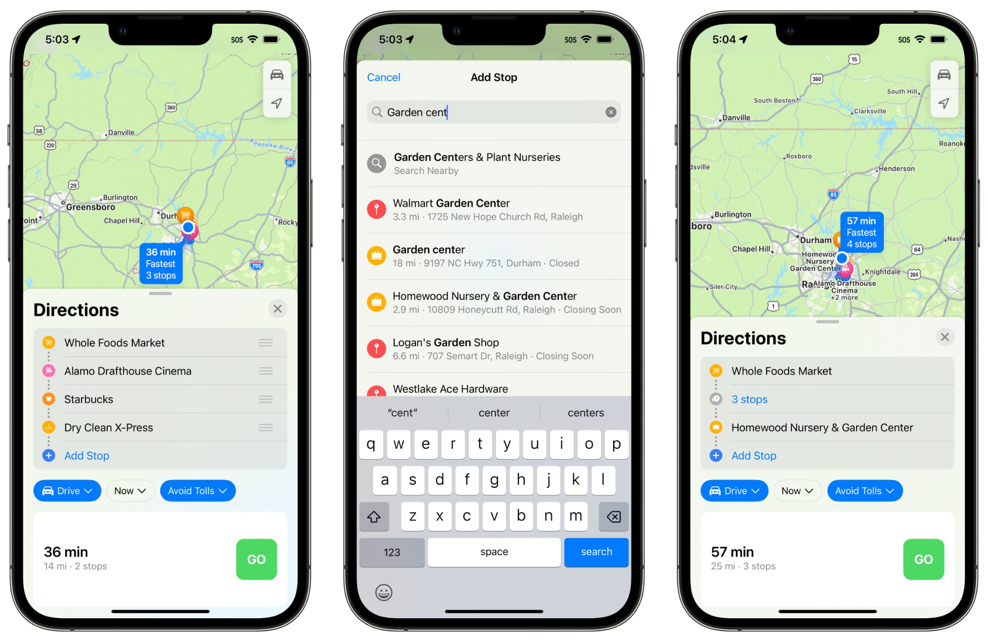
When you type in a destination in the Maps app in iOS 16, you can tap on the new "Add Stop" button to choose multiple locations. Up to 15 locations can be added on one route, and the Maps app will go to each stop in turn. Note that the Maps app does not optimize the route, so you'll need to do that manually when you type in stops.
Add Stops With Siri
If you're already on the road and want to insert a stop into your route, you can use Siri voice commands to do so.
Plan Routes on Mac
For planning a trip with multiple stops, you can get everything ready on the Maps app on Mac, then port it over to the iPhone when you're ready to go.

Maps Interface Updates
To accommodate the new multi-stop routing option, getting directions has been streamlined. It's simpler to change between driving, walking, transit, cycling, and ride share.
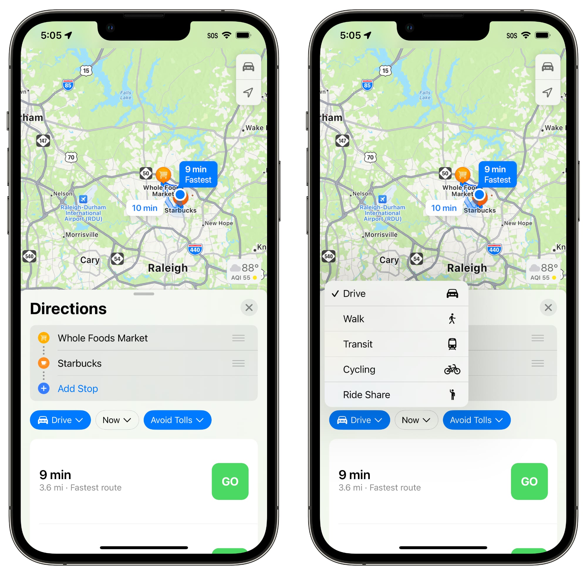
There are also drop down menus for changing travel mode, time you want to leave, and options to avoid tolls or highways, which makes it quicker to drill down into your preferences when getting directions.
The recent routes that you've used will show up in the Recent section for quicker access.
Transit Cards in Maps
Transit cards added to the Wallet app are integrated into the Maps app, so you can see if your balance is low and add more funds without having to swap over to the Wallet app.

Transit Fares
When planning a transit route, you can see how much it will cost in transit fares in select cities.

Photo Use Permissions
The Maps app in iOS 16 has a toggle for allowing companies to use photos that you upload using the built-in Maps rating feature. This is applicable to companies that provide photos to Maps, and it includes location information, but not identity.

Revamped Apple Map Design
Apple in iOS 15 introduced a new, more detailed Apple Maps design that provides more detail for roads, pathways, greenery, and more. The updated Maps app is coming to the following countries in iOS 16:
Guide Feedback
- Belgium
- France
- Israel
- Liechtenstein
- Luxembourg
- Monaco
- Netherlands
- New Zealand
- Palestinian Territories
- Saudi Arabia
Have questions about Maps in iOS 16, know of a feature we left out, or want to offer feedback on this guide? Send us an email here.
Article Link: What's New With the Maps App in iOS 16: Multi-Stop Routing, Transit Card Support and More
It hasn’t been real time. Most of the time I have to go into Find My and it will tell me where the other person is as of one or two or three or more minutes ago and then I wait , sometimes forever, for it to update. And then it takes a minute or two or three to update again.What do you mean? It’s been there for ages. You can share your real-time location from Messages and Find My.
It would be nice to compare to see how accurate your speedometer is and Apple maps is for determining travel time.Does your speedometer not work?
Where did they get such information? Or is this just Bier and StammtishThanks to our data-protection zealots, we‘ll never see the update in Germany
I haven't tested it yet, but it looks like once you run a route using watchOS 9, on subsequent runs you can select it as your running workout and run against yourself. No way to set up a new route ahead of time though.Could this be used for planning circular cycle/running routes and have it sent to your Apple Watch? At present apple maps doesn't let you plan routes, just start and end points.
Wow, still no Offline maps download? Pathetic.
Phone turns into a brick when you're out hiking or no reception, damn. 🧱
Can I finally download maps for offline use?
Offline maps still not present is highly disappointing. It is a critical feature and why I always have to keep google maps. That and no music controls are basics which are present in other apps. SadI agree. Looking at grid lines does me no good. The map developers need to get out of the Bay Area and visit parts of the world with poor or no cell service.
Correct me if I’m wrong, but the only reason google maps can do all those things is because they track every single android user without their permission.I actually prefer Apple’s navigation directions more than any other app. The maps are the easiest on the eyes and the directions are the easiest to understand. Siri’s voice is a lot more natural compared to Waze too.
I wish Apple Maps had look around everywhere like Google Street View. Apple had cars all over the U.S. for years now, so I don’t know why look around is so slow to roll out and so limited.
I also desperately wish Apple Maps had first party reviews right in the app and showed how busy a location was (and it’s usual business depending on the hour and day of the week) like Google Maps does.
I find myself stuck in between maps apps because of this. Apple is great for navigation. Google Maps is better for discovering places, seeing business levels, and for reviews/questions about places. Waze is best for rough traffic, road trips, or the most up to date road status.
I wish Apple Maps could combine the best features of all three apps.
Yup, I have Google Maps 😉Except you can do that with Google Maps on iPhone. I would still like it if Apple Maps could do it, but your phone doesn’t have to be a brick.
Apple Maps directions changes according to sunrise and sunset, not according to how your light and dark mode is set. The app background changes to dark mode but not the actual route. At least that is the way for me. I would like to have light mode map display all the time, as I can do with Google Maps but there is not setting for that in Apple Maps.I wait until general availability before I install new releases so I haven't seen iOS 16 Maps yet but from what I read I fear that Apple hasn't added the one thing that I want most and that is what in my view is "proper" theme control.
I run my iPhone in dark mode because I like the dark look on most of my apps plus, quite importantly for me, it improves battery life on a device with an OLED screen. The glaring exception to this however is mapping apps where on any device I sort of feel as if I'm in perpetual night time whenever I try to navigate using a map in dark mode and I also find labels such as street names seem to be a lot less easy to read but unfortunately as far as I have been able to tell the Maps app always follows the overall light/dark theme of the iPhone with no ability to override that.
In my opinion every well constructed app should offer an explicit three-way choice for its theme namely "light", "dark" or "follow device default". That should give everyone the options they need and I could leave my overall iPhone default theme as "Dark" and explicitly set Maps to always run in "light" and my problem would be solved. I would be perfectly willing to try Maps as my main mapping app but since it always goes into dark mode due to my iPhones default settings I would not consider moving away from Google Maps until that changes. (Changing my iPhone to light mode to get Apple Maps running as I want it to isn't a solution because I then run into the issue of other apps that have the same lack of full theme control always running in light mode when I want them to run in dark mode.)
Yup, Apple forces my hand to open google maps when I want to find a place to eat or often even just locate a business. Apple Maps is third class as a business directory. Also not great at knowing general places of interest. Yet it’s first class for driving navigation, so much better than google in that arena. Really wish Apple would just let me use their app for everything.I actually prefer Apple’s navigation directions more than any other app. The maps are the easiest on the eyes and the directions are the easiest to understand. Siri’s voice is a lot more natural compared to Waze too.
I wish Apple Maps had look around everywhere like Google Street View. Apple had cars all over the U.S. for years now, so I don’t know why look around is so slow to roll out and so limited.
I also desperately wish Apple Maps had first party reviews right in the app and showed how busy a location was (and it’s usual business depending on the hour and day of the week) like Google Maps does.
I find myself stuck in between maps apps because of this. Apple is great for navigation. Google Maps is better for discovering places, seeing business levels, and for reviews/questions about places. Waze is best for rough traffic, road trips, or the most up to date road status.
I wish Apple Maps could combine the best features of all three apps.
Living in Denmark I expect not to see any of these features. Apple is very limited in their features when it comes to spread it out to more countries. It’s like they develop a feature, include it in the product for the US, set the tick mark that’s it is done and then stop spreading it out to the rest of the world.
Sorry, I need to rant every time I see some new Maps features and know that the rest of the world only gets small part of these features and Apple don’t seem to care.
Still don’t have swipe keyboard in my native language. No word predictions. Stuff that 3rd party keyboards have had since 3rd part keyboards became a thing.
Waze interface on CarPlay is bad, very low resolutionMulti stop is great. But I still prefer the Waze interface when driving